Quantcast
Channel: Gian and Sheila – Adrenaline Romance
Viewing all 334 articles
Browse latest View live

Puerto Princesa Subterranean River National Park: A Magical Journey (Part 1)

$
0
0

Puerto Princesa Underground River

The Philippines is laden with wondrous natural treasures whose beauty defies imagination. Unfortunately and unfairly, these magnificent sites are unheard of due to the lack of a clever, strategic tourism campaign. Most tourism campaigns focus on enchanting but the same old things about the country—white-sand beaches, rich diving sites, Spanish churches and remnants, exotic culture, delicious food, and hospitable locals—for years. The Philippines needed something new.

Puerto Princesa, Palawan, has its own natural treasure, which took years before it was recognized the world over. The Puerto Princesa Subterranean River National Park, commonly known as the Puerto Princesa Underground River (PPUR), was a faint bleep in the country’s tourism radar. Then in the early 1970s, geologists, scientists, and adventurers began to take notice of this marvel of Mother Nature. Word-of-mouth from explorations, research results, and other documentation about the subterranean river began to flow.

Then, in November 2011, the province of Palawan—and consequently, the nation—had a big break. Puerto Princesa Underground River was selected as one of the New 7 Wonders of Nature. With the confirmation of the inclusion on January 28, 2012, the Puerto Princesa Subterranean River National Park became one of the country’s best known attractions, which helped place us back on the global tourism spotlight.

A trip to Puerto Princesa is not complete without visiting this amazing limestone river. So definitely, we included visiting the river in our tour.

We started the day with a hearty breakfast. It was going to be a long day, so we needed to fill ourselves up with a big breakfast.

Puerto Princesa Underground River

The van picked us up at around 7:30 AM. Wasting no time, we went straight to the other side of Puerto Princesa where the PPUR is located. Along the way, we saw the majestic, virgin mountains of Palawan. Basing on a Puerto Princesa Tourist Information Map we got from the airport (for free, we might add), this must be the Mt. Peel mountain range.

Sweetie and I couldn’t help but ask about any mountaineering clubs or organizations in Palawan that can help us in our future Palawan climbs.

Puerto Princesa Underground River

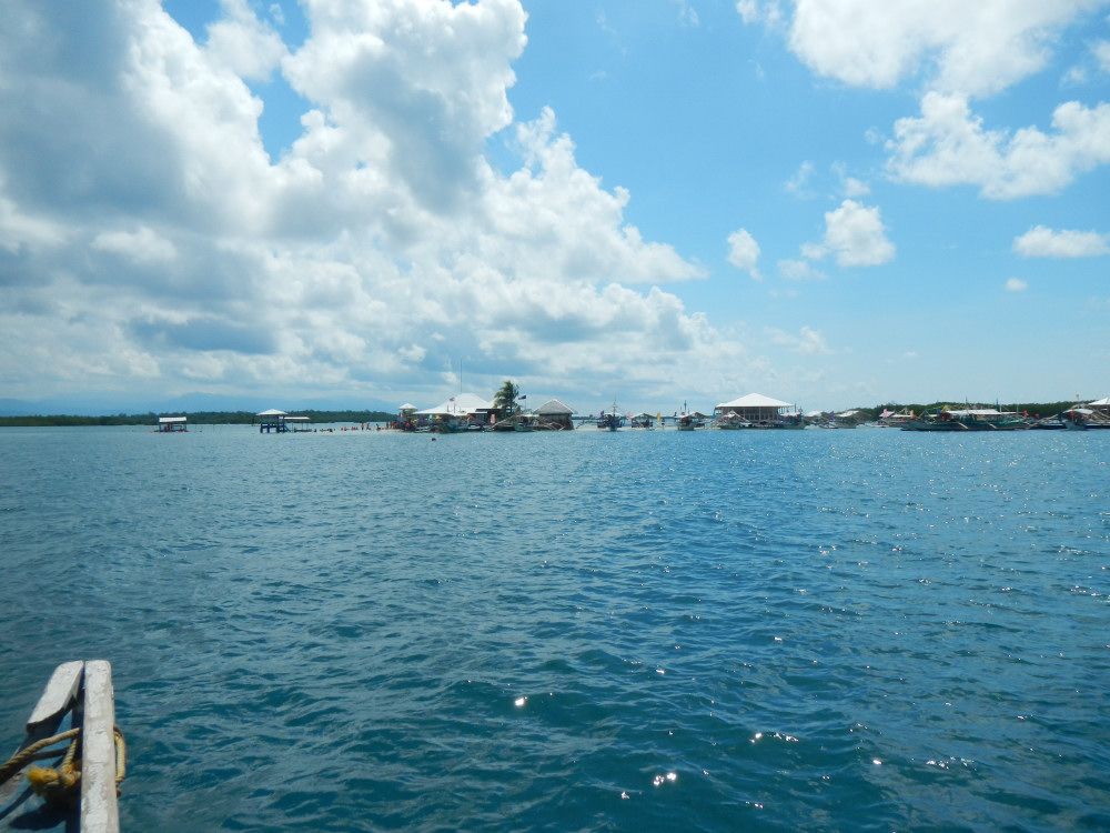
The drive to PPUR from the city is quite long, around 2 hours. So, after an hour, tour groups heading to the underground river usually stop by at Jazz Souvenir and Coffee Shop to have a bathroom break, grab something to eat, take a few souvenirs, or simply stretch their legs out. This pit stop also offers a marvelous view of the picturesque Ulugan Bay.

Puerto Princesa Underground River

Ulugan Bay serves as a direct gateway to the West Philippine Sea. At this vantage point, you can see the snakelike Isla Rita and the faraway triple-crown island of Tres Marias.

Puerto Princesa Underground River

After 15 minutes, we were again on the road to the Puerto Princesa Subterranean River National Park. We found beautiful limestone karst formations such as these along the road. Many of these karst formations are far bigger and taller than the cliffs of Cantabaco and elsewhere in Cebu. If only they were not far from the city center, these karst formations can be excellent candidates for bolting to introduce the sport of rock climbing in Palawan.

We thought we saw the best karst formations that are ideal for rock climbing. These were just teasers because several minutes later, we arrived at what Palaweños called Elephant Mountain, which is a gigantic mountain that is karst limestone in its entirety! More on that later.

Puerto Princesa Underground River

After more than two hours on the road, we finally reach Sabang Wharf, which is the actual starting point of the PPUR tour. See that beach? That’s a public beach with a wharf beside it. Now, check out the sand and the water. Aside from washed up sea grass, driftwood, and other natural debris, you can’t find any man-made garbage. That is how disciplined Palaweños are.

Puerto Princesa Underground River

Just look at that water! It’s so clear it’s almost glasslike. And with the mountains in the background, you can’t help but feel calm and peaceful in the midst of excitement.

Puerto Princesa Underground River

Aside from littering, smoking is not allowed in public places except in designated areas. The fines are pretty hefty, and if you commit a fourth offense, you get free board and lodging—in the city jail.

Puerto Princesa Underground River

This is the registration center in Sabang Wharf. Since we already paid for the tour, our guide took care of everything, including our registration. We only paid for the environmental fee of P40.

Puerto Princesa Underground River

Now, here’s something very important that you need to know—and do—when planning for a trip to PPUR. This becomes even more important if you intend not to hire a tour agency or guide. On June last year, Puerto Princesa enacted Resolution No.06-2012, which is a resolution approving the revised management conditions for tourist entry to the Puerto Princesa Subterranean National Park. According to the park policy in verbatim:

“To protect and preserve outstanding universal values of the Underground River, Management has to set a carrying capacity for the Underground River and is strongly enforcing a No Permit, No Entry policy to support it. All visitors are required to secure an entry permit at the Underground River Booking Office at the PPSRNP Office, City Coliseum, Barangay San Pedro, Puerto Princesa City or call Tel. No. (048) 434-2509.”

In other words, apply for a permit while you are still in the city proper. The registration center won’t issue permits; they just issue passes, certifications, and other requirements for the tour. Upon registration, don’t forget to bring a government-issued ID, such as driver’s license, SSS, or Voter’s ID.

Puerto Princesa Underground River

While our guide, Jeron, processed our papers, we took time to explore Sabang Wharf. We found several inns such as this to house tourists. Yes, some tourists spend a night here so they can join the early-morning tours to avoid the influx of visitors in the later hours of the day.

Puerto Princesa Underground River

The distance from the city proper to Sabang Wharf makes it very difficult for the capital to provide electricity to Sabang. In fact, there are no electrical lines in this area. Thus, residents use solar power to provide their electrical needs. See those square things on the lamp posts? Those are solar panels that provide power to those posts. We even saw humble kubos with solar panel arrays on their roofs! Now that is eco-friendly, sustainable power generation!

Puerto Princesa Underground River

It was still 9 AM, and the waiting area was chock-full of tourists! According to a PPSRNP official that we talked to, about 1,000 tourists in a day visit the Puerto Princesa Underground River. They limit the daily visitors to 1,000 to protect the natural treasure.

Puerto Princesa Underground River

Gasoline-powered bancas (outrigger boats) ferry passengers to Sabang Bay, which is a 20-minute ride away. These bancas can accommodate four to twelve passengers, depending on their size. Take note that these boats are NOT the ones that go inside the cave.

Puerto Princesa Underground River

After waiting for around half an hour, we finally boarded our assigned boat. At this point, we were just so excited that we could hardly keep still.

Puerto Princesa Underground River

All set and definitely, definitely ready to go. Utmost excitement and pure joy are written all over our faces! Who wouldn’t be excited and happy? We’re visiting one of the New 7 Wonders of the World, man!

Puerto Princesa Underground River

As we cruised the length of Sabang Bay to get to the wharf, we saw this imposing mountain. If our hunch is right, this is the gigantic Mt. Cleopatra, or Cleopatra’s Needle, according to the Tourist Information Map. See that white strip at the mountain’s middle? That is a gigantic limestone karst wall—yes, an entire mountainside—which is perfectly suited for rock climbing. We’ll show you a better photo of that cliff in a later article.

Puerto Princesa Underground River

As we neared Sabang Beach, we witnessed a rare spectacle of nature. We saw large fish jump out of the water. We thought it was just an ordinary occurrence; often, fish do jump up and skim the water’s surface if they sense a boat coming towards them. It was then when we looked up and saw this, a huge white-bellied eagle that is actually hunting! As city dwellers, we rarely see this in our lifetime!

He kept soaring around the area, looking for prey. It was such an awesome sight; the magnificence of the eagle filled each soul in the boat with wonder. Even our boatmen, who have lived all their lives in the sea, stopped the boat to admire the sight. They said that they haven’t seen an eagle’s actual hunt before.

Because they slowed down, we were able to get some amazing shots of this death-from-above avian.

Puerto Princesa Underground River

We don’t have an uber-zoom or telephoto lens, so we couldn’t take a clear photo of him. He probably looks like this. Photo credits to Wikipedia.

Puerto Princesa Underground River

As we went farther from Sabang Wharf, we saw rock-protected, sandy coves that are totally devoid of human habitation. Perhaps this is why that white-bellied sea eagle we saw earlier decided to hunt here. White-bellied sea eagles are often found in places where there is little or no human interference; human interference easily drives them out.

Puerto Princesa Underground River

Our boatmen announced that we were nearing Sabang beach as we approached this rock outrcropping. This wall of sharp rocks acts as a curtain to the marvelous sight behind it, which completely took our breath away—literally.

Puerto Princesa Underground River

That’s the other side of the wall, which shields Sabang Beach from view.

Puerto Princesa Underground River

See those boats ahead? That’s Sabang Beach, the entry point to the Puerto Princesa Subterranean River National Park. That’s where we were going.

Puerto Princesa Underground River

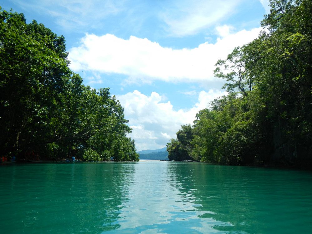
We told you that the sight took our breath away, right? Well, let’s go for starters. Check out this beautiful, unspoiled limestone cliff. Underneath that cliff is cool, aquamarine water that is so clear and clean that it is difficult to believe that it is actually seawater!

Puerto Princesa Underground River

Just look at those towering limestone cliffs with that clear, clean aquamarine water! Any visitor would feel a sense of calm, peace, and happiness here.

Puerto Princesa Underground River

A better view of the limestone cliffs can be seen in Sabang Beach. There’s something spiritual about this place. There’s something magical here that reinvigorates the soul yet humbles our self-made pride. Just check out the natural beauty; this photo couldn’t even come close to the actual place. The silent grandeur is bigger than we could ever imagine.

Puerto Princesa Underground River

Yes, we had to get wet. The cool water and fine-sand beach looked so inviting that we could have just simply strip off to our swimwear and plunge in. But . . .

Puerto Princesa Underground River

Swimming is strictly prohibited here. That’s because the whole bay is a marine sanctuary.

Puerto Princesa Underground River

At last, we were at the footsteps of the Puerto Princesa Subterranean River National Park, our very own successful entry to the New 7 Wonders of the World.

Puerto Princesa Underground River

Before we trekked to the staging ground of the PPUR, we had to register for the final time. We think this is done to keep close tabs to the number of visitors. Remember, the local government has to limit the number of visitors to minimize or prevent damage to a very delicate subterranean ecosystem.

Puerto Princesa Underground River

The entire park largely consists of the St. Paul Limestone Formation, which is considered a National Geographical Monument. Put in another way, the Puerto Princesa Underwater Cave is inside the St. Paul Limestone Formation.

Puerto Princesa Underground River

The declaration sign also features a cross-section view of the Puerto Princesa Underwater Cave.

Puerto Princesa Underground River

Here’s a crude map of the Puerto Princesa Underwater Cave. As you can see, this is a huge, very complex cave system that spans more than 8 kilometers inside a limestone mountain!

Puerto Princesa Underground River

The Park has a ranger station to keep visitors and staff safe and secure. Rangers also intercept occasional intruders who intend to poach or illegally extract natural resources.

Puerto Princesa Underground River

Non-English speaking or Tagalog-speaking foreigners can avail of Audio Tours. Basically, they listen to a pre-recorded tour in a language they choose while they take an excursion in the underground river. It’s a pretty cool concept, actually.

Puerto Princesa Underground River

Airy sheds such as these provide guests with a place to rest, relax, or eat. No, they’re not cottages like those in a public beach.

Puerto Princesa Underground River

After everyone in our tour group has registered, we made our way into the forest. Our guide explained that before the PPUR became a tourist spot, adventurers had to trek a couple of kilometers to get to the mouth of the cave. Today, they just need to follow the wooden path to get to the Puerto Princesa Underground River staging area.

Puerto Princesa Underground River

A board that explains why forests are vital to the global ecosystem. Would you believe that this forest is still first-generation? There are over 295 species of trees here—most of which are of diterocarp variety—including ipil, dita, apitong, and dao. And that’s just a fraction of the more than 800 plant species that researchers found in the park.

Puerto Princesa Underground River

Along the way, we were greeted by the sight of the park’s natural denizens like these scary-looking monitor lizards. Yes, they are quite large. The lizard in the first photo is perhaps around four to five feet long, from snout to tail. Don’t get too close; they might attack you.

Puerto Princesa Underground River

We also saw cute monkeys that actually step, sit, and walk with humans on the trail. Now, you might wonder why these wild monkeys seem so comfortable with humans? In most of our treks, wild animals quickly scamper when they sense human beings nearby.

Puerto Princesa Underground River

Well, the bitter and sad answer can be eloquently expressed by the photo below. Irresponsible tourists throw snack wrappers or feed the monkeys with food. This act changed their natural feeding habits. They now think that humans carry food; that’s why they wait patiently on the trail for scraps. In addition, realizing that garbage can equate to food, the monkeys do not hesitate to pick up discarded candy wrappers, bubble gum, snack pouches, etc. in the hopes of getting a morsel.

Puerto Princesa Underground River

After 10 minutes, we arrived at the staging area and donned on our life jackets and helmets.

Puerto Princesa Underground River

The staging area is actually a small, shady beach beside a narrow estuary lined with rock walls and virgin mangrove forests. An estuary is a partially enclosed coastal body of water in which one or several rivers or streams flow into it and freely connects to the sea. Thus, the water here is brackish.

Puerto Princesa Underground River

Then we saw the monstrous mouth of the Puerto Princesa Underground River and the awesome rock formation that surrounds it. Seeing the cave filled us up with feelings of amazement, excitement, fear, and dread. Mother Nature is beautiful, uplifting, and dangerous at an impossibly grand level. Looking at this natural treasure, we felt the pangs of humility in the sense that nature is so much bigger than we, humans, can possibly imagine. For us, Nature is God; and undertaking this excursion made us feel spiritually closer to Him.

Puerto Princesa Underground River

Sweetie and I positioned ourselves at the back of the boat so we won’t have to be the people who will hold the lamp at the front. Bwahahahaha! Well, we want to sit directly in front of the boatman who will guide us inside.

Puerto Princesa Underground River

Life vests? Check! Helmets? Check! Headlamps? Batteries full and A-okay. Electronic gadgets, documents, and wallets? Thoroughly waterproofed. Cameras? Already in the right settings. Sweetie and I are ready to go!

Puerto Princesa Underground River

That’s our really cool, funny, and knowledgeable guide and rower.

Puerto Princesa Underground River

And off to the gateway to the center of the earth we go. See you on Part 2.

Puerto Princesa Underground River

Tips

1. It would cost you a considerable amount, but if you wish to visit the Puerto Princesa Subterranean River National Park, it is best to let a tour operator or travel agency do it for you. Your tour operator or travel agency will take care of all the permits, land transportation, boat transportation, and other aspects of the tour for you. All you have to do is to give the amount to the service provider then sit back and relax.

2. Booking the Puerto Princesa Underground River tour yourself can definitely save you a whole lot of money. However, considering that you will be dealing with the local government, be prepared for lines, headaches, and a lot of hassle.

3. The PPUR Office is located at the City Coliseum. You can get there by riding a tricycle; fare is between P8 to P12 per person depending where you are.

4. The PPUR Office is open from Mondays to Fridays, from 8AM to 4PM with no lunch break. They are also open on weekends, Saturdays and Sundays, at 8AM to 12PM. The staff goes for a one-hour lunch break and resumes at 1 PM. The office closes at 5PM.

5. To apply for a permit, check the following steps:

Step 1: Get a transaction number and wait for your turn
Step 2: Fill out the form and submit personal details for processing.
Step 3: If you’re a walk-in visitor, proceed to Counters 1 and 2. Tour operators and travel agencies line up on Counters 3 and 4.
Step 4: Let the staff compute the payment.
Step 5: Obtain the signature of a PAMB representative to finalize your permit.

6. Permit Fees
* General Entrance Fees to the Puerto Princesa Subterranean River National Park

  • Adult (Filipino) – P100
  • Minor (Filipino) – P75
  • Adult (foreigner) – P150
  • Minor (foreigner) – P100
  • Senior Citizen – P100
  • Differently Abled – P100

* Cave Entrance Fees

  • Adult (Filipinos) – P175
  • Minor (Filipino) – P100
  • Adult (foreigner) – P250
  • Minor (foreigner) – P150
  • Toddlers and children 3 to 12 years old – P75. Children below 2 years old are not permitted for safety reasons.

Remember that prices may change without an advance notice. Thus, it is best to contact the PPUR office for the latest prices, updates, and policies. Use these contact details:

  • Telephone No.: (048) 723-0904
  • Telefax: (048) 434-2509
  • E-mail: info@puerto-undergroundriver.com, undergroundriver_ppsrnp@yahoo.com

7. The PPUR office usually has a long line of applicants. And considering that the local government limits the visitors to PPUR, there is a chance that you may not get a slot. To increase your chances of success in booking a PPUR excursion, visit the PPUR office early on Mondays and Thursdays. Try to avoid Fridays and weekends.

8. After getting the permit, you still need to find a way to get to Sabang Wharf from Puerto Princesa proper. There are vans for hire, jeepneys, and buses that travel there. Since we bought a tour package, we were simply fetched at the hotel by a tour van.

If you wish to save money and take the bus or jeepney, at Puerto Princesa city proper, take a tricycle to the New Market Jeepney Terminal. Take a minibus or jeep going to Sabang. There are four trips that run daily from the terminal to Sabang between 7AM and 2PM. Fare costs roughly around P150, and the trip takes around 3 hours.

9. Once you get to Sabang Wharf, have your permit processed at the registration center. Please remember that the registration center in Sabang Wharf does not issue permits! Never forget to apply for a permit at the PPUR office in the city first before coming to Sabang Wharf.  And don’t forget that you need to pay P40 for the environment fee.

10. Once you arrive at Sabang Wharf, hire a boat to take you to Sabang Beach. Ask the locals where you can hire a boat. Then negotiate for a reasonable fee, usually around P300 to P800.

11. Do not feed the monkeys or lizards in the National Park. Feeding them can alter their normal feeding patterns. Needless to say, do not throw trash anywhere in the Park. Dispose of your trash in designated garbage bins.


Puerto Princesa Subterranean River National Park: A Journey to a Mountain’s Heart (Part 2)

$
0
0

Puerto Princesa Underground River

In Part 1, we told you about the beautiful scenes and adventures as we journeyed to the Puerto Princesa Subterranean River National Park. Now, let’s go into the subterranean cave itself.

The Puerto Princesa Underground River is basically a complex river-cave system that has been carved inside the stunning karst mountain called St. Paul’s Karst Formation by the forces of Mother Nature. For millions of years, the constant flow of water from the Cabayugan River coupled with rain that seeps into the ground slowly but surely carves passages and cathedrals inside the mountain. The mountain itself is 1,026 meters high, and the entire park is a UNESCO World Heritage Site.

Puerto Princesa Underground River

Nearing the cave’s giant mouth, we can’t help but experience an ominous but grand feeling. Not just because we were actually going to experience a Natural Wonder of the World but also because we were going to witness just how awesome the power of Mother Nature is.

Puerto Princesa Underground River

Like a massive mouth from some Lovecraftian monster, the entrance of the cave is filled with these massive teeth-like, moss-covered stalactites. Stalactites are a type of drip-stone speleothems, or formations of secondary mineral deposits. The deposits remain in contact with the ceiling of the cave and builds over time as water deposits more minerals on the formation. Most stalactites have hollow centers. Watch your head as you enter the cave; some of the stalactites hang low on the water.

Puerto Princesa Underground River

The cave is lined with various types of rock. Some are as smooth as granite while others are rough like this speloegen. Just check out the photo. It looks like we’re going inside the throat of a monstrous creature.

Puerto Princesa Underground River

The entire cave network is actually 24 kilometers long. However, the Puerto Princesa Underground River itself is 8.2 kilometers long and empties into the West Philippine Sea. Only 4 kilometers of the underground river is navigable by boat. Tourists are permitted to explore 1.2 kilometers of the underground river; the rest of the river is off limits except for geologists and researchers. Furthermore, to explore the deeper parts of the underground river, you need to secure a special permit.

Puerto Princesa Underground River

See those dark streaks on the wall? That’s guano, or excrement from bats. Guano is a valuable fertilizer due to its high nitrogen and phosphorus content. In the past, it was a primary source of nitrates that are used to formulate gunpowder.

Puerto Princesa Underground River

A few minutes into the cave, we are greeted by this monstrosity. Our guide called this the T-Rex as it resembles the head of a Tyrannosaurus Rex. The T-Rex is just one of the unique rock formations that line up this amazing natural wonder.

Puerto Princesa Underground River

Behind the T-Rex is a weird stalactite the guide called The Crocodile. The T-Rex, The Crocodile, and other rock formations are formed with a process called precipitation of carbon carbonate. Drops of water carry minute amounts of minerals. When the water evaporates, it leaves behind the minerals. Over millions of years, the minerals accumulate, birthing stalagmites, stalactites, and other forms of speleothems.

Puerto Princesa Underground River

Natural cavities like these, shaped by Mother Nature’s persistent hand, line up some parts of the cave’s interior.

Puerto Princesa Underground River

As we moved deeper into the cave, we were treated to a spectacular sight—this huge stalagmite with its own island within a massive chamber the guide called The Italian’s Chamber! We estimate this stalagmite to be as large as a two- or three-story house.

Puerto Princesa Underground River

Check out the photo above. Can you see how high the Italian Chamber is? Our light can’t even reach the ceiling—that dark void above us!

That bird is a swiftlet, one of the many creatures that have adapted to the conditions in the cave. Because the inside of the cave is enveloped in total darkness, a swiftlet navigates its way and hunts for prey through the use of echolocation. Echolocation is Mother Nature’s sonar and radar. The bird produces a chirp whose sound wave is too high for humans to hear. When the sound wave hits the object, some of the waves bounce back to the swiftlet. The bird hears/receives the sound and uses the data to pinpoint prey or to find their way around.

Swiftlets use their saliva to build their nests, which are glued on the cave walls. Brave souls climb the steep and razor-sharp walls of the caverns to pry out these nests. The nests are then processed as the main ingredient of bird’s nest soup.

Puerto Princesa Underground River

The Pegasus stalagmite, named after the mythical winged creature in Greek mythology, is one of the stalagmites on the island.

Puerto Princesa Underground River

The eerie Holy Family is another set of stalagmites in The Italian Chamber island. Stalagmites such as these are formed when water drops from the ceiling to the floor of the cave. As the drops impact the floor, they release their “load” of mineral deposits. As time goes by (and we’re talking millions of years here), the minerals accumulate and crystallize, forming pointed formations commonly known as stalagmites.

Puerto Princesa Underground River

Doesn’t this stalagmite remind you of something? Anyway, after quite some time, the mineral deposits of stalactites and stalagmites sometimes meet together. This leads to a formation called a column.

Puerto Princesa Underground River

This stalagmite is so massive that our boat’s floodlight couldn’t illuminate the whole thing. The guide called this rock formation The Candle. It is one of the largest and tallest stalagmites in the Puerto Princesa Underground River.

Puerto Princesa Underground River

We encountered other tourists who visited the cave earlier. Just wave and don’t point your light at them.

Puerto Princesa Underground River

Deeper into the cave, we encountered these strange rock formations that resemble giant mushrooms and vegetables. These are called draperies or curtains.

Puerto Princesa Underground River

Here’s a closer look of a beautiful drapery. This flowstone formation is made by water that flows on the walls. However, instead of dropping to the ground, the water “sticks” to the wall. As the water evaporates, it leaves behind a string of mineral deposits, which, over time, form into this kind of rock formation.

Puerto Princesa Underground River

That’s a really long drapery that originates all the way up from the ceiling. It’s magnificent, isn’t it? Water is extremely soft, gentle, pliable, and formless. Yet, this gentle liquid can carve the hardest stones, form the longest valleys, and topple down the highest mountains. Artfully, we might add. Nature is indescribably amazing!

Puerto Princesa Underground River

More strange draperies. We had fun listening to the guide as he rattled off the names of the draperies, which he based on vegetables. “That’s the Upo” or “Can you see the Puso ng Saging?” Of course, the draperies do look like the vegetables he enumerated.

Puerto Princesa Underground River

As you probably can tell, Sweetie and I had a fun with the educational trip in the darkness.

Puerto Princesa Underground River

The guide warned us to close our mouths if we wish to look up. Why? Well, check out those black spots on the roof. Those are bats, clinging precariously on the ceiling walls. Now, what has that got to do with keeping our mouths shut? Well, put it this way: the ceiling continuously drips with water. Unfortunately, not everything that drips is water. And if it gets into your mouth, you might taste something that is a little bit more than water.

Puerto Princesa Underground River

After 40 minutes, we reached the end of the publicly allowable and navigable length of the underground river and made a U-turn. Going beyond this point requires a special permit from the government. Even then, you need to be a certified geologist, biologist, researcher, etc. to go further down the river.

Puerto Princesa Underground River

After around half an hour, we finally saw a glimmer of day!

Puerto Princesa Underground River

Then we’re out of the cave. Look at that cool, clean, brackish water! By the way, the guide told us that that average depth of the water in the PPUR is 11 meters.

Puerto Princesa Underground River

Now, that is a pretty, welcome sight! After an hour in the cave, we were ready to embrace daylight.

Puerto Princesa Underground River

That’s the sparkling clean Cabayugan Estuary immediately in front of the subterranean river. The water in this estuary flows through the cave toward the West Philippine Sea.

Puerto Princesa Underground River

Adventurous, cool couples meeting together! That’s Team Sweetie together with Kiethleen and Kenneth. We just met during this adventure and were thrilled to know that they are from Cebu. We later found out that this tour was part of their honeymoon! Congratulations!

Puerto Princesa Underground River

On our way back to our boat, we couldn’t help but admire the pristine sand of Sabang Beach. Beach lovers would definitely need to be strong-willed to be able to resist the temptation of diving in. Of course, they’re not permitted to swim here as this is a protected area.

Puerto Princesa Underground River

That’s our cool guide Jeron. He’s really lively, knowledgeable, and entertaining. The tour won’t feel dull or boring when you’re with him.

Puerto Princesa Underground River

Jeron and Sweetie! Jeron can also arrange or help you with your Puerto Princesa tour.

Puerto Princesa Underground River

The majestic Mt. Bloomfield loomed across the distance as we headed back to Sabang Wharf.

Puerto Princesa Underground River

No, that’s not a colurom van or V-hire. That’s our tour van. In Puerto Princesa, tourists head out to tourist spots in these very well-maintained vans, which can be hired for a reasonable price. Also, a person who wishes to operate a tour van must apply for certain tourist certifications and licenses. He may undertake seminars and workshops sponsored by the local government’s tourism office. Once the applicant accomplishes the requirements, he is given a Gabay sa Turismo sticker, which must be placed at the side of the vehicle. Vehicle with such stickers are recognized as legitimate tour vans.

Puerto Princesa Underground River

Finally, we were treated to a wholesome eat-all-you-can lunch at the Queen Ann Divine Eatery, which is a simple Filipino-style restaurant.

Puerto Princesa Underground River

All in all, our Puerto Princesa Subterranean River tour was truly mind-blowing. For starters, we were able to visit an internationally known natural icon, a World Wonder at that! We met new friends. We learned more about the wondrous geo- and ecosystems that dwell in cave systems. We became more adamant advocates of the preservation of the environment.

Most importantly, Sweetie and I were able to reconnect our souls to Mother Nature in this dark, strange world as we witnessed her awesome power to enchant, bewilder, provide, or terrorize mankind.

Tips

1. For tips about getting a permit to enter the Puerto Princesa Subterranean River National Park, fees, commuter schedules, things to bring, and other information, check out the Tips section of Part 1.

2. We highly recommend Jeron Paduga if you are looking for a guide during your Puerto Princesa tour. He is very knowledgeable, helpful, fun to be with, and can make your adventure really worthwhile. Get in touch with him using the following contact details:

  • Cellphone number: 0915-2011550 or 0920-2797013
  • E-mail address: ron_paduga@yahoo.com

Please negotiate your guide fee with him. We availed of a package early on, thus, his guide fee was included in our package.

3. If a van driver/guide offers you a Puerto Princesa tour, always check if his van has the Gabay sa Turismo sticker. If it doesn’t have one, then it is likely that he’s operating illegally. You may also ask for his tourism ID. Accredited guides such as Jeron always carry with them proper tourism IDs.

4. For more information about the Puerto Princesa Subterranean River Park, please use the following details to contact the PPUR Office:

For rates, business hours, and other information, please check the Tips section in Part 1.

5. Four kilometers of the cave is navigable by boat. However, for tourism and recreation, guides and tourists are only allowed to go 1.2 kilometers. Beyond that, you need a special permit from the PPUR office.

6. As per Republic Act No. 9072 or the National Caves and Cave Resources Management and Protection Act, the following acts are considered prohibited and illegal in PPUR and in any cave system in the Philippines:

  • Knowingly destroying, disturbing, defacing, marring, removing, or harming any rock formation of any cave or altering the free movement of any animal or plant life into or out of any cave;
  • Gathering, collecting, possessing, consuming, selling, bartering, exchanging, or offering for sale cave resources without authority;
  • Counseling, procuring, soliciting, or employing any person to violate any of the prohibitions in RA 9072.

7. Help keep the Puerto Princesa Underground River a treasure to behold for many generations to come. It’s easy; just a bit of discipline is needed.

  • Do not throw your garbage (even organic ones) during the Park tour and the underground river cruise. Put your rubbish in designated garbage cans. Better yet, put them inside a plastic bag and dispose the bag when you’re back in your hotel.
  • Do not touch the rock formations. These are very delicate and the slightest touch can irreparably damage what Mother Nature has worked on for millions of years.
  • Do not make any loud noise. Not only do loud noises disrupt the serene experience of the cruise but they also disturb the habits of cave-dwelling animals.
  • Do not feed any animal that you come across with; you might disrupt their natural feeding pattern.

8. Make the experience enjoyable to everyone by adhering to the following simple rules:

  • Do not make any sudden movement in the boat. Remember that the boat it small, and rocking it is especially unnerving for other passengers.
  • If you are seated in front, most likely, you will be holding the boat’s spotlight. Yes, it might be tedious or annoying following the guide’s directions on where to shine the light. If you don’t wish to be tasked with such duty, sit in the rear.
  • Listen to the guide/rower to make the trip informative and entertaining.
  • Do not shine the light on boat coming in from the other direction.
  • Do not eat during the cruise.
  • Be aware that the person behind you may want to take photos in front of you. If he or she intends to do just that, move your body slightly to the side until he or she takes a shot.
  • Be courteous to your fellow passengers in the boat.

9. We received a query from a reader: “Can I bring and use a camera in the PPUR?” Yes, you can, and you can use a flash too.


Elephant Cave Karst Mountain and Ugong Rock Adventures: Adrenaline on the Rocks

$
0
0

Ugong Rock Adventures

After concluding our Puerto Princesa Underground River tour with a sumptuous lunch, we headed to Barangay Tagabenit to try out another one of Puerto Princesa’s Ugong Rock Adventures. This was not included in our tour package, but we decided to visit Ugong Rock since we felt we need a dose of adrenaline. But before we reached the destination, we stopped by this magnificent, colossal karst mountain the locals call Elephant Cave.

Elephant Cave and Karst Mountain

See how immense that mountain is? That’s somewhat like an entire mountain range, cliff, and rock face made of limestone! The photo below feature just a tiny portion, perhaps 1/8th, of the entire karst formation.

Elephant Cave Karst Mountain

Elephant Cave Karst mountain’s immensity, ideal location (just beside the main road, actually), and unspoiled limestone, makes it an ideal candidate as the Philippine’s biggest, most extensive, and best rock climbing site. Elephant Cave has so many excellent rock faces that are ideal for bolting; we think it can easily rival the limestone formations in Krabi or Tonsai, Thailand.

The only problem is that—being so far away from civilization and being in a place where modern conveniences are not readily available—it is, for the moment, impractical to come here. But who knows? An influential person from Palawan might read this blog post and pitch in the idea to the LGU.

Elephant Cave Karst Mountain

The limestone wall serves as a shield for these huts. The cave itself is nestled within the rock. Our guide, Jeron, said that as of the moment, Elephant Cave is still being mapped out and explored. Thus, tourist entry is not possible yet.

But just think: probably in the future, there would be three adventures—caving, trekking, and rock climbing—in this area. Extreme adventurers would have a heyday!

Elephant Cave Karst Mountain

Fronting the karst formation are immense rice fields. Now that is a sweeping, serene, pastoral panorama that we like to see whenever we wake up in the morning.

Elephant Cave Karst Mountain

A gigantic limestone monolith stands guard over the rice fields. We can envision a nice viewing terrace on top, or perhaps, a zipline going down. The possibilities of extreme adventure are endless here.

Elephant Cave Karst Mountain

We thought that we’ve seen the largest and most extensive limestone formation in the country. But then, we saw this: an entire side of Mt. Cleopatra that is essentially a gargantuan rock face! Combined with the Elephant Karst Rock, Palawan definitely has a major rock climbing site that spans an entire barangay or municipality!

Elephant Cave Karst Mountain

Ugong Rock

There are only a handful of places in the world where you can engage in a whole set of extreme adventures in one setting. From these places, only a few are conducive for people who wish to experience how it is to feel the adrenaline rush in extreme adventures for the first time. Ugong Rock in Barangay Tagabenit, Puerto Princesa, Palawan is one such place. And—you guessed it—we visited it during our anniversary.

Ugong Rock is a 23-million-year old, 75-foot limestone limestone karst that stands like an immortal guardian of rice fields. Upon undertaking the adventure, one can experience more than an hour of trekking, caving, and scrambling. At the summit of Ugong rock, one is treated to an all-around view of mountains, karst formation, and green rice fields. Finally, to get down, one takes a zip line, reputed to be the fastest in the country.

Ugong Rock Adventures

The reception area was our first stop where visitors pay for the adventures and briefed on the history of Ugong Rock and precautions so the activities can be undertaken safely.

Ugong Rock Adventures

Ugong Rock Adventures is actually a community-based sustainable tourism project. It is supported by the Puerto Princesa local government, the Department of Tourism, the Bantay Kalikasan Foundation, and ABS-CBN. With this project, local farmers now have the means to generate income for the community via a sustainable, eco-friendly utilization of natural resources. The guides here are trained local farmers.

Ugong Rock Adventures

After paying our dues, the farmer guides suited us up with safety helmets and gloves. Yes, gloves; the rocks are pretty sharp, and we want to protect our pinkies. Knowing that we were going caving, we carried our own headlamps.

Ugong Rock Adventures

The adventure starts with a short trek towards the mouth at the base of the Ugong Rock limestone formation. While we trekked, the skies opened up a little, and rain started to fall.

Ugong Rock Adventures

In less than 10 minutes, we were at the cave’s entrance where overhanging rocks provide a kind of roof to protect us from the rain.

Ugong Rock Adventures

Ugong Rock is basically a huge moss-covered limestone formation. It’s very otherworldly, and entering the cave feels as if entering the haunted Paths of the Dead, the forbidden mountain passage where Aragorn, Legolas, and Gimli traveled to ask the assistance of the Army of the Dead.

Ugong Rock Adventures

Upon entering the cave, we were immediately treated to Mother Nature’s proud exhibit of beautiful rock formations carved for thousands or millions of years with her own gentle but persistent hands.

Ugong Rock Adventures

Relatively young deposits of calcium carbonate can be found in many areas. In time, they will harden as drapery-style flowstones.

Ugong Rock Adventures

Going through Ugong Rock’s Cave felt like going through a man-made tunnel; it just involved an easy walk. However, the rock formations are really naturally sculpted by nature.

Ugong Rock Adventures

The roof of the cave, which is several storeys high, is home to bats, swiftlets, and other cave-dwelling animals.

Ugong Rock Adventures

Ugong Rock does not feature a continuous cave. You need to trek for a little while at the rock’s base to get to another cave that leads to the karst formation’s summit.

Ugong Rock Adventures

More moss covered limestone formations dot the outside of the cave. Be careful, the moss makes them quite slippery.

Ugong Rock Adventures

Oh, yes, you need to bend, crawl, and do a little bit of yoga to fit into small places like this.

Ugong Rock Adventures

Locals have placed wooden stairs in some parts of Ugong Rock to assist tourists. While the rocks can definitely be climbed without aid, it is always better to be on the side of safety.

Ugong Rock Adventures

A bamboo bridge is constructed to cross a chasm. The squeaky, creaky sound may be unnerving, but don’t worry. That bridge is very strong.

Ugong Rock Adventures

From the bridge, we saw a beautiful view of the forest. Nature never ceases to amaze us.

Ugong Rock Adventures

Look at those gorgeous, unspoiled rock formations inside the cave. The centerpiece is that stalagmite pointing directly at a stalactite. Thousands of years from now, that formation will become a column. The nice thing about these rock formation is that they sparkle when you shine a light on it thanks to glass-like quartz crystals.

Ugong Rock Adventures

Those are our cool, knowledgeable guides. During off-peak season, they resume their work in the nearby fields as farmers.

Ugong Rock Adventures

Midway to Ugong Rock is a stop where we were fitted with a harness. That’s because to go up, we need to climb up 12 feet of near vertical rock. Going through this section of the cave requires a little bit of technical climbing.

Ugong Rock Adventures

Fixed ropes are rigged to assist climbers up the steep slope. Anyone who tried rock climbing or scrambling can just clamber up without the ropes; in fact, it was easier for me to scale the vertical tunnel without the assistance of ropes. However, the ropes are there for safety, so use them.

Ugong Rock Adventures

After the short climb, we reached a small “room” where we rested for a little while.

Ugong Rock Adventures

Ten minutes later, we continued on our way up another wall. Fixed ropes made the ascent easier and safer.

Ugong Rock Adventures

After almost an hour in the belly of Ugong Rock, we finally came out into the light.

Ugong Rock Adventures

But that also meant we had to crawl on our hands and knees so we can proceed up . . .

Ugong Rock Adventures

. . . and squeeze past passages that were barely wide enough to let a single human being go through.

Ugong Rock Adventures

Finally, we saw a set of wooden stairs, which directly leads to the zipline starting point at Ugong Rock’s peak.

Ugong Rock Adventures

Going up! The rain made the steps quite slippery, so we had to be careful not to slip.

Ugong Rock Adventures

To give you a sense of scale, check out Sweetie at the lower right of the photo. Yes, that’s how vertical the stairs are, and that’s how immense that rock outcropping is.

Ugong Rock Adventures

Finally, after an hour of walking, scrambling, spelunking, and climbing, we reached the top of Ugong Rock. This is the start of the zipline that will take us back to our starting point. We can always trek back and climb down, but zipping down is much quicker and more exciting! Here’s a trivia: the Ugong Rock zipline is the first zipline in Palawan.

Ugong Rock Adventures

While waiting for our turn, we looked around and admired the beautiful vista. Ugong Rock provides a fantastic vantage point that overlooks the community below and the surrounding karst topography.

Ugong Rock Adventures

It was Sweetie’s turn to get ready for the zip. Check out that first-class safety equipment! They have Petzl and Black Diamond harnesses and helmets. Wow! We don’t even have rock climbing helmets in our rock climbing equipment cache!

Ugong Rock Adventures

Ugong Rock’s zipline has a different design than most ziplines we know. Thus, it’s important to read the instructions for safety. The outfitters, who are also farmers, also told us what to do as we zip towards the end of the line.

Ugong Rock Adventures

Sweetie was all set and pretty excited to try the fastest zipline in the country. She will have to hold her guts for 21 seconds for the 350-meter ride.

Ugong Rock Adventures

And off she went . . . screaming her heart out. I thought that I can hold my scream, but I wasn’t able to. You know why? Well, I’ll tell you in the last photo, which will show you a better vantage of Ugong Rock’s zipline. After trying it, Sweetie and I have to say . . . it is the fastest zipline we’ve ever experienced.

Ugong Rock Adventures

Can you spot Sweetie? She’s just a tiny speck of orange. The zipline crosses a large rice paddy.

Ugong Rock Adventures

That’s Ugong Rock, that huge limestone outcropping covered with vegetation. You can see the zipline’s starting point at the summit. Now focus on the zipline’s cables. You would notice that from the starting point, the cables drop steeply—almost vertical, in fact—before they come up to a gentler angle. That means, you’re actually falling from Ugong Rock before the zip rights itself up to a more manageable slide! Now, you tell us: who wouldn’t scream when he or she falls down a cliff?

Ugong Rock Adventures

Our Ugong Rock experience was definitely refreshing. The entire adventure, from trekking to ziplining, was pretty basic; however, after a half-day city tour and a half-day river cruise that involved doing nothing but just sitting there, we were very glad and relieved that we were able to actually do something that quenched our thirst for adrenaline

Tips

1. Here are the rates for Ugong Rock Adventures. All rates are per person and are subject to change without prior notice:

  • P200 – caving
  • + P250 – going down via zipline
  • + P200 – going down via rappelling
  • P200 – rock climbing (although I haven’t seen any bolts, chocks, draws, or other rock climbing gear in sight)

Do not haggle. Remember that this is a community project.

2. Ugong Rock opens at 8 AM and closes at 5 PM daily, including Sundays and holidays.

3. For more information and for reservations, you can contact Jet or Marivel at these phone numbers:

  • 0930-8622750
  • 0918-7558993

4. As mentioned earlier, we took a packaged tour, so the transportation from Sabang Port to Ugong Rock was free. However, check out the details below if you intend to commute your way to Ugong Rock.

  • From San Jose Terminal in Puerto Princesa city proper, take a jeep, bus, or van going to Sabang. Inform the driver to drop you off Ugong Rock. Ugong Rock can easily be reached by a short dirt road that connects to the main highway. The dirt road has a sign of Ugong Rock, which is hard to miss. Van fare is around P 130, while jeepney fare is around P 100. Travel time from the city to Ugong Rock is around 1 hour and 30 minutes
  • From Sabang Port (after your PPUR cruise), ride a tricycle to Ugong Rock. Since there is no fixed fare or official route, you need to negotiate a price. Travel time from Sabang Port to Ugong Rock is around half an hour.

4. To get back to Puerto Princesa, hike back to the National Road and wait for a jeepney that goes back to San Jose Terminal. We do not have any information about the fare, but we reckon it should be around P100 or less.

5. If you are suffering from a cardio-respiratory ailment, it is best to have your blood pressure taken at the reception area before climbing Ugong Rock. This is to guarantee that you are adequately fit before you can climb.

6. After paying, you will be fitted with safety gear. Don’t worry, they practice good hygiene and they thoroughly clean the equipment after every use.

7. Since the guides are only issued a flashlight, it is recommended that you bring along your own headlamp or flashlight.

8. Pack light but bring the following

  • water (at a liter)
  • trekking attire
  • rubber shoes or trekking sandals
  • umbrella, hat, or sarong
  • snack
  • headlamp (highly recommended)
  • rain gear (in case of bad weather)
  • extra money for emergencies
  • camera

Honda Bay Island Hopping: Experiencing the Splendor of Puerto Princesa’s Seas

$
0
0

Honda Bay

For Filipino and Filipina lovers of sand and beaches, there are two things that define summer: swimming at the beach and island hopping. In Puerto Princesa, you get both! We capped our third day of adventuring with a boat tour on the islands that dot Honda Bay, a natural, serene, and scenic bay at the east of Puerto Princesa’s City Center. Honda Bay has several islands but only a few of them are open to tourists. The rest are protected areas or are now privately owned.

Now let’s talk about island hopping for a second. Do you know that the term “island hopping” has a military origin? Yes, during World War 2, the Allies, specifically the Marines, would land their landing crafts on a Pacific island, go into battle to take it from the Japanese, and then go to the next one. This military maneuver was called “island hopping.” Today, island hopping now refers to the recreational activity of renting a boat, visit islands, enjoy the sea and the beach, and then come back to the mainland later in the day.

We started out early, around 7:00 AM. Our guide, Ron, fetched us from our hotel, together with a few other island hoppers. Soon, we were on the road to Honda Bay wharf. As you can see, the Puerto Princesa LGU is serious in making their city and province a world-class tourist hotspot starting off with an excellent road network and transportation infrastructure.

Honda Bay

On the way to Honda Bay wharf, we stopped by at Panz Mask and Snorkeling Shop where people can rent snorkeling and free-diving equipment. We rented two sets of snorkeling masks (P150 per person) and booties (P150 per person). People with non-waterproof cameras can also rent waterproof casings here.

Honda Bay

From Panz Mask and Snorkeling Shop, we arrived at the Honda Bay wharf. While waiting for our guide to process our permits, we took time to take photos of the wharf. As you can see, the Honda Bay wharf is well equipped to handle tourists. It has a large tourist assistance center, a Philippine Coast Guard office, an ample large parking area, and a waiting area for those waiting for their boats.

Honda Bay

The wharf also offers spectacular view of the entire Honda Bay area.

Honda Bay

Even at this early, island hoppers were already jamming the waiting area. The frenzy of activities picked up as the morning wore on.

Honda Bay

After half an hour of waiting, we finally got our own motorized outrigger that will ferry us to the Honda Bay islands. This 4-cylinder engine boat can carry 10 passengers. But before we boarded the boat, Ron instructed us to remember the boat number. That’s because there were a whole lot of similar-looking boats once we reach the island destinations. Obviously, we don’t want to be riding a different boat, do we?

Honda Bay

After donning our life vests, everyone was pretty excited for the island hopping trip. For Betina, the German lady whom we initiated a conversation with, it was her first time riding an outrigger towards several tropical paradises in the span of a single day! She was pretty excited.

Honda Bay

And off we go! Goodbye, Honda Bay wharf for now. We’ll see you again in the afternoon.

Honda Bay

Pambato Reef

Our first stop was Pambato Reef, a small, protected underwater reef that locals dub as a mini-Tubbataha reef. We knew we were approaching Pambato reef when we saw this “parking lot” full of boats.

Pambato Reef Honda Bay

We half expected Pambato Reef to be like the Hilutungan Marine Sanctuary in Lapu-Lapu where boats tie in on floating buoys around the reef. We didn’t expect that the LGU actually created a floating structure (carefully anchored, of course) just beside the reef. Narrow walkways lead from the docking area to the staging area.

Pambato Reef Honda Bay

The staging area is this large floating platform with a giant turtle on top. All around the platform are photos and information about reef systems and the various marine life that inhabit the Pambato Reef.

Pambato Reef Honda Bay

This guide was funny . . . and clever at the same time! After the mandatory briefing, he added, “And on May 13, don’t forget No. 16, Edward Hagedorn, for senator.” Hehehe! Anyway, we second safety checks and the customary group pictures.

Pambato Reef Honda Bay

Then it was our turn to dive into the cool water. Pambato Reef is 15 to 20 feet below the surface, but the areas around the reef are abyssal in depth. That’s why even for swimmers, life jackets are required. Check out the throngs of people enjoying the water and the underwater sights.

Pambato Reef Honda Bay

At first, we couldn’t see anything but an endless void of green. Then after a few minutes, the beauty of the underwater landscape of Pambato Reef filled our view. Gradually, we witnessed an underwater landscape of unspoiled corals.

Pambato Reef Honda Bay

We saw fan-shaped corals like this. It was so tempting to touch it, but that’s around 15 feet deep from the surface. Now, you may wonder why the water has a green tinge. Well, with so many people snorkeling around, it is inevitable that silt and particles in the water get stirred up. Silt and minute particles make the water slightly green.

Pambato Reef Honda Bay

It was an awesome experience to see the secret homes of fish.

Pambato Reef Honda Bay

A coral encrusted rock served as a cleaning station where wrasses and cleaner shrimp pick off ectoparasites from the scales and skin of other fish.

Pambato Reef Honda Bay

This was the first time in many years that we’ve seen a live giant clam. Seeing this monster down there was exhilarating as well as mystifying. Mankind has gained a lot of knowledge about the cosmos but has barely scratched what waits to be discovered in the alien world beneath the sea.

Pambato Reef Honda Bay

Lilu Island

After half an hour of snorkeling, we went back to the boat to visit our next destination: Lilu Island. This is not really an island in the real sense of the word but a sandbar. During low tide, the sandbar becomes visible; and during high tide, it becomes covered with water. Thus, the name Lilu, a portmanteau of the Tagalog words “lilitaw” (floats) and “lulubog” (sinks).

Lilu Island Honda Bay

Similar to our very own Pandanon Island as well as other islands in the Olango and Hilutungan Channels, Lilu Island is developed for tourism. Thus, you can see structures such as cottages, floating platforms, rooms, and markers. Personally, we think it has lost its original beauty, but the place is still ideal for beach lovers.

Lilu Island Honda Bay

Mangroves are aplenty at the eastern side of the island. It’s a good thing the development of the island did not touch these mangroves. As you know, mangroves are very important in marine ecology. The presence of mangroves and a dock suggests that Lilu Island is a rich fishing ground.

Lilu Island Honda Bay

After seeing the diving board, I just couldn’t resist! And yes, it’s exhilarating!

Lilu Island Honda Bay

The sandbar is actually a semicircle bordered by a patch of mangroves with a shallow lagoon in the middle. You can walk along the sandbar and have picture-perfect moments here as long as you don’t go beyond the marker flags. The fine sand is lovely; we had fun digging our feet into it. And yes, the water is crystal clear.

Lilu Island Honda Bay

Kayaks are available for rent here. You can safely kayak at the inner side (the lagoon) of the sandbar like these tourists.

Lilu Island Honda Bay

For your own safety, you’re not allowed to swim or go beyond those marker flags.

Lilu Island Honda Bay

After more than an hour of swimming, our guide called us for lunch! It was about time. We were starving! Hehe! We took our lunch in one of the cottages in Lilu Island. The cool thing about this was that we ate lunch with our feet in the water!

Lilu Island Honda Bay

We had a classical, sumptuous, beach-perfect lunch of grilled pork, adobong manok, kangkong and tomatoes, and fried shrimp. The two foreigners with us enjoyed the food so much and commented that it was one of the best meals they ever had. Yes, our cuisine may be simple, but they pack a punch!

Lilu Island Honda Bay

A few minutes after our meal, this creature floated near our cottage. That’s a pufferfish, and although it was dead, we were still amazed at its shape and size. When threatened, a pufferfish swallows either air or water to inflate its elastic stomach. The sudden inflation either startles or discourages the predator from eating a spiky ball instead of a tasty fish.

Pufferfish are known to be some of the most venomous in the animal kingdom. Internal organs such as the liver, and even the skin, are full of tetrodotoxin, a highly lethal poison. However, daring and skilled Japanese chefs may carefully prepare pufferfish meat (called fugu) as a delicacy, isolating parts that are safe to consume.

Lilu Island Honda Bay

A short while later, a guide came strolling by and proudly showed us his catch, a live, poisonous jellyfish. It’s safe to hold the head, but be damned careful not to touch those tentacles! The tentacles are poisonous and can cause severe irritation and burns. He walked towards the end of the sandbar and released the creature back into the sea.

Lilu Island Honda Bay

Cowrie Island

After filling up our tummies with a delicious lunch, we swam for a little bit more before we headed to our last Honda Bay island hopping destination, Cowrie Island. The guide earlier told us that the place is aptly named because it is shaped like a cowrie shell. As we approached Cowrie Island, we didn’t find any resemblance of it to a cowrie shell.

Cowrie Island Honda Bay

We guessed that the name Cowrie Island came from the fact that cowries (sigay in Cebuano) were once abundant here. Apparently, they were harvested by local fishermen. The island was then converted to a resort.

Cowrie Island Honda Bay

Welcome to the lovely, white-sand Cowrie Island!

Cowrie Island Honda Bay

Cowrie Island is a small rock outcropping that prominently juts out of a hidden atoll. As you can see, it’s a perfect paradise for beach lovers. These serene places are some of the reasons why foreigners fall in love with the Philippines.

Cowrie Island Honda Bay

The flimsy shade of coconut trees is not enough to lessen the full blast of the sun. You may want to stay under these nice huts for more shade.

Cowrie Island Honda Bay

To while off the time, our guide and some of his friends played volleyball on the island’s sandy court.

Cowrie Island Honda Bay

Of course, an island hopping trip is not complete without swimming in the world-renowned clear waters that make the Philippines a perfect haven for scuba divers, snorkelers, windsurfers, and anyone who loves the sea. That’s Cowrie Island’s swimming area. For safety, swimmers are not allowed to cross the buoys.

Cowrie Island Honda Bay

Palawan’s tourism branch takes the safety of tourists and the preservation of its marine resources very seriously. We saw similar signs such as these in the destinations we covered so far. And yes, Cowrie Island has a lifeguard, so you should feel really safe swimming here.

Cowrie Island Honda Bay

So Sweetie and I did not hesitate. We jumped right in and enjoyed the warm water and fine sand. Yes, with sunglasses to look cool. Hehe!

Cowrie Island Honda Bay

Cowrie Island also has other facilities to keep tourists entertained. For instance, they have this nice bar that serves you with your favorite drink. And if you feel sore from all that swimming, you can always have those aches vanish with the help of professional masseurs.

Cowrie Island Honda Bay

Swimming and being bombarded by the sun’s heat can definitely made us thirsty. So we opted to refresh and reenergize ourselves with fresh coconuts. As with any other tourist destination, the price of coconuts sold is many times higher than normal.

Cowrie Island Honda Bay

We caught a giant starfish, held a gigantic clam’s shells open, and drank from a colossal coconut. Hehe! Not really. One of our boatmen, a photography enthusiast, borrowed our camera to try out an experiment. We were delighted when he showed his shots to us. That’s forced perspective!

Cowrie Island Honda Bay

Pristine Beach

We were back at our hotel, the Kookaburra, at around 5:00 PM. The nice thing about this hotel is that it’s only five minutes away from a popular public beach called Pristine Beach. It was great timing since we’ll be able to watch the fantastic Puerto Princesa sunset.

Pristine Beach

Trees with large canopies shield beachgoers from the sun and rain. It’s like walking into a jungle but with a beach at the end. How cool is that!

Pristine Beach

The path to Pristine Beach cuts through a dense patch of mangrove. During high tide, seawater can reach this area and cover the path. Apparently, as seen in the photo below, the tide was quite high that morning.

Pristine Beach

That’s Pristine Beach. Entrance fee is P20. There were only a few people around when we came in, probably because the tide was low. We could imagine throngs and crowds of beach lovers enjoying the sand and sea here.

Pristine Beach

The retreating sea left its footprint, graceful lines and channels in the mudflats that is home to crabs, shrimps, mollusks, and other creatures of the sea.

Pristine Beach

Low tide is when you can actually glimpse of marine ecology in action. This is when you can truly see large patches of pneumatophores, a mangrove’s breathing organs. We also saw small crabs that quickly burrow under the sand the moment they sense vibrations. Those strange formations on the sand? Those are actually their burrows.

Pristine Beach

A few minutes later, the sun began to say goodbye to a long day in its own breathtaking splendor.

Pristine Beach

There’s nothing more romantic than holding your sweetheart amidst a spectacular sunset. I love you so much, Sweetie.

Pristine Beach

Going Home

All too soon the next day, we were scheduled for our flight back home. To tell you honestly, we really didn’t want to leave Puerto Princesa, but it was time to go back to our jobs, responsibilities, and lives.

Puerto Princesa Anniversary Adventure

As you probably can tell, we were extremely satisfied and happy with our Palawan Anniversary tour. It was one very special anniversary, and we want to celebrate it this way again on our second anniversary next year in El Nido.

Puerto Princesa Anniversary Adventure

Goodbye, Puerto Princesa! We’ll see you again soon. We are forever grateful for letting us see the majesty of your wonders and treasures. We are forever grateful for giving us a rare opportunity to immerse in your culture. We are forever grateful for letting us experience your adventures. We are forever grateful for keeping us safe and sound. We are forever grateful for the lessons and knowledge you imparted to us. Most of all, we are forever grateful for making this anniversary so special that it strengthened our love and desire for each other.

Puerto Princesa Anniversary Adventure

Tips:

1. The Honda Bay wharf is around 20 to 45 minutes from the city center. You can opt to hire a tricycle for around P300 to P500 at the city center to get to the wharf.

2. Unlike the Puerto Princesa Underground River tour where you have to book your reservation in the PPUR office, you can book your Honda Bay tour at the Tourist Information Center at the wharf. It is better to go there early so you can avoid long lines of island hoppers. There were already a lot of people when we got there at around 8:00 AM.

3.  Just like the rates of PPUR tour services, the prices are strictly controlled. Below are the rates for the boat rentals, island entrance fees, scuba tours, environmental fee (P40, the figures are covered by the plant in the photo below), etc.

Honda Bay

The steps to getting a permit are clearly posted in the Tourist Information Center. If you have any questions or concerns, just approach any tourism personnel stationed there.

4. On the way to the wharf, you will stop by a small shop where you can rent snorkeling and diving equipment. You can also rent waterproof cases in case you have a non-waterproof camera. We only rented booties and snorkeling masks, so if you want to rent other equipment such as flippers and wet suits, you have to ask the shop’s representative or owner.

  • Booties: P150
  • Mask with snorkel: P150

Be very careful not to lose what you rent or else, you are going to pay a hefty fine of P1,000 per item.

Unless you intend to wade in the islands of Honda Bay on low tide, there’s no need for booties. Also, if you want to save money, we suggest bringing your own snorkeling equipment and booties.

5. If you have a life jacket, we highly recommend bringing it with you. Yes, it may be bulky. However, the life jackets provided by boatmen are extremely ill-fitting (usually too loose) and of very poor quality. In fact, they may be injurious because they are too loose. Once you’re in the water, the jacket’s neckline/collar rises up to your neck and may become a choking hazard.

Secondly, the jackets are uncomfortable since they are too loose. Mine bit through my armpits as I swam in the water. Lastly, the design does not allow you to tighten the straps to hug your body. Thus, if you raise your arms, you may actually slip off your jacket.

6. We’re not sure if lunch is provided in a do-it-yourself tour; we had free lunch because ours was a part of a tour package. Therefore, bring your own meals, snacks, and drinks just to be safe. Remember that the foodstuffs and beverages sold in the Honda Bay islands are at least three times the price of that in the city.

7. Pack light but bring the following:

  • water (at least two liters)
  • sandals
  • umbrella, hat, or sarong
  • snacks and softdrinks
  • bathing suit and swimming attire
  • sunblock
  • a small bottle of vinegar (for jellyfish stings)
  • extra clothes
  • extra money for emergencies
  • camera

Guest Post: Five Hidden Beaches of the Philippines

$
0
0

Philippine Beaches

As an archipelago with over 7,107 islands, the grandeur of the Philippines can be daunting when searching for the perfect vacation spot. So many of the islands are tourist friendly, and with so much to do, even a quick trip to the Philippines gives vacationers the chance to truly customize an unforgettable trip.

The most well-known beach in the Philippines is the white sand beach of Boracay. Touted by travel magazines and agencies all over the globe as the quintessential beach of the region, Boracay offers the typical accommodations you’d expect from a world-renowned beach-resort, luxury hotels, gourmet food, spa treatments, water sports and rentals and a sizzling nightlife.

For those wanting to get off the beaten tourist trails, however, the hidden beaches of the Philippines offer a variety of unique, once in a lifetime experiences. Listed below is just a small sample of the many beautiful beaches scattered throughout the Philippines:

Matukad Island

Matukad Island
Photo courtesy of Flickr

Located across from another popular beach, Gota Beach, on Camarines Sur, is Matukad Island. It sports sandy white beaches similar to those found on Boracay, but has quite a few unique features, like a set of limestone cliffs right at the beachfront. Like Gota Beach, where Survivor was filmed, Matukad Island maintains an uninhibited, raw beauty for those looking for a more authentic island experience.

Mahabang Buhangin

Mahabang Buhangin
Photo courtesy of Flickr

On the Calaguas Islands of Camarines Norte, you can find the uninhabited beach, Mahabang Buhangin. This island is custom tailored to adventurous types looking to rough it. First, you must travel over two hours on the open seas to get here. You are encouraged to bring a tent or backpacking equipment if you plan on staying overnight. The beach has a steep slope, so swimmers beware. The beach is fairly long, with no signs of civilization, so the memories you take from Mahabang Buhangin will be undoubtedly original.

Siargao Islands

Siargao Islands
Photo courtesy of Flickr

The Siargao Islands, in Surigao del Norte, are an often overlooked by typical tourists, but sport enthusiasts will find them the perfect spot for surfing, no matter what skill-level you are at. The breaks range from low, to moderate to up to three-meters-high for pros. These islands are a great Fall destination for pro surfers looking to get away to an inspiring new territory.

Pagudpud

Pagudpud
Photo courtesy of WikiCommons

A sleepy getaway from the hustle and big city life, Pagudpud, of Ilocos Norte offers solitude and wide open spaces to play in. The Blue Lagoon in Maira-ira sports a gorgeous turquoise blue hue, and there are still a few rice fields left to explore. Photographers will go wild for the monolithic windmills further down near the town of Bangui. The high winds are also an excellent source for windsurfers, surfers and kiteboarders looking to step up their game.

Balesin

Balesin
Photo courtesy of Flickr

Balesin resides on the Polillo Islands of Quezon, and has become quite a forgotten island over time. Production of the island as a tourist haven halted years ago, and left many of the island’s infrastructure simply unfinished. But that doesn’t mean it’s not worth travelling to. The only two ways to get there are either from a 4-hour boat ride or a chartered flight. Halted developments have left the island resort in need of improvements, but if you don’t mind a little character, then it is a wonderful spot with beautiful beaches. Gradual beach slopes make swimming easy for those travelling with kids. Beautiful sand and ocean for miles make this a relaxing getaway worth checking out.

The Philippines is an amazing travel destination for those looking to get away from it all and enjoy some fun in the sun and the cool breeze. With so many unique beaches to choose from, there is no shortage of adventurous combinations.

About the author:
Angie Picardo is a writer for NerdWallet’s travel blog, TravelNerd, where you can find advice on setting goals to best save for your trip to the Philippines.


Quiot to Toong to Jaclupan Trek: A Wilderness in the City

$
0
0

Quiot Pardo

Metro Cebu is obviously a very well developed city. Highly urbanized, it offers locals and foreigners alike countless opportunities for work, living, and leisure. But just like in any highly urbanized metropolis in the world, something must inevitably give way. In most cases, it is nature that is forced to step aside. Cebu’s rapid growth and progress has led to denuded forests, cleaved mountainsides, damaged reefs, polluted waters, and dried-up rivers.

Reading from the paragraph above, you may have a perception that Cebu is an environmentally doomed city. You may have an image of Cebu that is a filthy, polluted, and devoid of forests. Well, hardly. Cebu still has a rich plethora of wild places carefully tucked into its highlands. If you know where to look, you will find breathtaking natural treasures that are worth a hearty adventure. And they’re just right in the city’s own backyard!

We had the opportunity to discover one of these treasured wildernesses last May 5, 2013, Sunday, through the help of Sir Sien, a close mountaineer friend of ours. After our Palawan anniversary tour, Sweetie and I decided to have a practice climb in preparation for an upcoming major climb this coming July 2013. Sir Sien immediately suggested a trek from Quiot, Pardo, Cebu; climb up and traverse the southern ridge of Antuanga (pronounced An-to-wa-nga) Ridge; then exit at the DENR reforestation area in Buhisan. Upon exiting, he recommended continuing the trek to Jaclupan in Talisay and finishing up in Igotan Cave. We figured it would take us 6 to 7 hours of trekking and climbing to complete the route, a fairly good-sized hike. A few friends, particularly Angel and Morey of Anjville’s Travel Blogs and More and their pals, wanted to tag along with us.

We met up at the McDonald’s outlet in Mambaling on one extremely sunny Sunday. Sir Sien fetched us then we proceeded to our jump-off point at San Carlos Heights where a few other hikers were waiting for our group. After a short prayer, we were on our way to Antuanga Ridge.

Quiot Pardo

The first few kilometers involved a steady climb on a concrete road. Basically, we are climbing towards the exit of San Carlos Heights. As we neared ridge’s southern ridge and the radio towers that dot it, the road became rough and rugged.

Quiot Pardo

We figured that the road we’re walking on is part of a local pilgrimage trail due to the presence of Way of the Cross stations. During Holy Week, this place must be chock-full of people.

Quiot Pardo

As we climbed higher, an encompassing and splendid view of the Cebu metropolis opened before us. The forest of towering skyscrapers, dozens of T-cranes, gigantic malls and buildings under construction, and sprawling communities signify the Cebuanos’ desire for Cebu to be a world-class city. And at this point, we can literally see the city’s progress.

Quiot Pardo

Sweetie and the City! Hehehe! We simply love our city’s skyline. We reckon that in just a handful of years from now, Cebu City will have a skyline that will rival those of Surabaya in Indonesia, Melbourne in Australia, Cordoba in Argentina, and other second-tier cities. Yes, we are proud Cebuanos.

Quiot Pardo

Angel, Morey, Apol, and Sweetie found a nice nook to seek refuge from the sun’s power. It was just past 8 AM, and the sun was already scorching.

Quiot Pardo

A short while later, we went off-trail to climb a steep hill to get to the start of the southern tip of the Antuanga Ridge. Loose rocks riddle the entire hillside so be careful when ascending here.

Quiot Pardo

We stopped to drink in the grandeur of Cebu’s coast midway up the hill. Check out the road below us so you can gauge how high the hill is.

Quiot Pardo

The hot, bright morning sun was practically baking the landscape. Thus, we were quite thankful when we saw this thick-canopied tree that stood beside the trail. You know, when you are into outdoor adventures, you tend to appreciate trivial things that you normally would take for granted like the shade that a tree offers. We stopped here for a few minutes to rest and to cool off.

Quiot Pardo

A short rest and we were ready to go again. The road (yes, it’s not a trail at this point) led us higher along the ridge until we came right under the massive towers that supply electricity to the city. If our hunch is right, these towers support electric cables that originate all the way from the power plant in Naga or Toledo. Needless to say, roads are established to allow technicians easier access to these towers.

Heartbreak Ridge

The “true” hiking/climbing trail of Antuanga Ridge started right after we passed the last electrical tower. But before we proceeded to the mountain’s spine, we found a store in Sitio Antuanga that offered ice-cold Coke and Sparkle, which are truly a mountaineer’s delight on a hot day. Cold soda is unhealthy, but up there under the heat of the sun, these cold drinks are sheer bliss!

Heartbreak Ridge

After taking huge swigs of Coke and Sparkle (and keeping some in our water bottles) to quench our thirst, we started a grueling ascent up the ridge. As you can probably tell in the photo below, the day was cloudless, and the trail was overly exposed. Imagine how hot this day must be. Too bad we didn’t bring along a thermometer.

Heartbreak Ridge

Along the way, we met a family of local woodcutters. They cut the branches of dead, dry trees somewhere then sell these branches as fuel for wood-fired stoves or burn them for charcoal. These folks gain profit at a razor-thin margin considering the great effort that they exert in harvesting these woods (for starters, just imagine cutting and carrying wood for hours under the sun). And with the advent of electric and gas-fired ovens and ranges, the business of serving the needs of those who still use wood or coal-fired stoves is rapidly declining.

Personally, this is a good thing. Foremost, trees are spared, and the mountain will have a chance to rehabilitate itself. Second, they will have to use more efficient and eco-friendly equipment for cooking. Businesswise, this might be grim for the woodcutters, but they have to adapt to a changing world.

Heartbreak Ridge

It was already 10 AM, and we’re racing to take refuge under the shade of that hut. That hut marks the topmost point of Antuanga Ridge. Sir Sien and bushman extraordinaire Sir Jing of Camp Red said that this ridge and Sitio Antuanga, which this ridge is named for, is full of tunnels that were dug by Japanese troops during World War 2.

Heartbreak Ridge

On this ridge, you can see the full glory of the Cebu province. The breathtaking panorama that encompasses azure summer skies, verdant fields, turquoise waters, the distant blue mountains of Bohol, and the cityscape below made us feel humbled and honored. It’s not every day that we witness incredible vistas such as this. Indeed, at this vantage, it’s not difficult to understand why Cebu is considered as one of the best islands in the world.

Heartbreak Ridge

The hut seems to be a rest area for woodcutters. And it offers a very beautiful view of Cebu City, the South Road Properties, the Mactan and Hilutungan Channels, and faraway Bohol, all in the foreground of a blue summery sky.

Heartbreak Ridge

Tiny tomatoes! They’re actually cherry tomatoes, and they’re perfect for hors d’oeuvres.

Heartbreak Ridge

A vastly different view of Cebu greeted us when we surveyed the northwest part of Antuanga Ridge. Cliffs, hills, light woods, and more mountains fill our vision. Focus on the bottom right photo. Can you see the woodcutters?

Heartbreak Ridge

After half an hour of resting, we continued our trek. As you can see, the summer sun was so hot that it burned leaves and bushes. But as we descended and entered the upper ridge of the DENR protected forest in Buhisan on the other side of the mountain, the flora once again became verdant and alive. The farther we went, the greener the plants seemed.

Buhisan DENR Reforestation Area

We followed a treacherous trail, the danger compounded by loose soil, above the reforestation area. At some portions, the trail is just wide enough to accommodate half your foot! One misstep to the right and you’ll be careening down the steep, slanted slope.

Buhisan DENR Reforestation Area

The changing scenery has much to be admired. So Sweetie and I decided to practice on our nature photography skills (specifically, composing the photo with unique angles) while trekking. I say we did a pretty good job, don’t you think? Entering the Buhisan reforestation was like entering a different world if only for an hour or less.

Buhisan DENR Reforestation Area

As we continued downhill, we heard a familiar sound—the unmistakable buzzing of a motorcycle’s engine. Could it be?

Buhisan DENR Reforestation Area

Indeed it was! We found a road!

Going to the right leads you to Buhisan Dam where the Metro Cebu Water District gets the bulk of its water. Going to the left, the direction of our hike, leads to a secluded barangay called Toong.

Buhisan DENR Reforestation Area

Arriving on the road, the team was so happy that Apol and Angel did a few cartwheels. Hehe! When you’re out there in the wilderness, the sight of a road in the middle of nowhere is always a welcome. With trees forming a wall on either side of the road, the road makes a cool postcard-perfect photo.

Buhisan DENR Reforestation Area

A few minutes of trekking led us to Barangay Toong where we refreshed ourselves with some Coke and biscuits. Feeling energized, we continued our trek towards a hidden river that divides barangays Toong and Jaclupan.

Toong

Along the way, the team met a couple of vendors selling fresh jackfruit, pineapples, and coconuts. We bought some for our dessert later on. The nice thing about buying fruits here is that you can save a lot; they cost less than when sold in the city. And somehow, they’re tastier here in the mountains.

Toong

We veered off the cemented road and followed a dirt trail that led us to a riverbank. As you can see, there are greens everywhere even though the area is quite populated.

Toong

After a quarter of an hour, we reached the riverbank. On a hot, sweaty day like this, the mere sight of a river is bliss. You’d know that somewhere out there is a cool pool or rush of water that is totally refreshing. Sweetie and I were even tempted to take off our shoes and just immerse our feet in the water.

Toong

The river-trekking segment of our adventure started. Watch your step and be careful here. Those rocks can be slippery due to the moss that clings on them.

Toong

Following the river led us to small patches of civilization. We even found a sari-sari store in what it seems to be the middle of the jungle! Farms, catch basins, small plantations of orchids, and a creaky bamboo bridge all add to the provincial feel of the place even though technically, we’re still in Metro Cebu!

Toong

It was also my first time to see a mango tree in full bloom. It looked amazing with green leaves and yellow baby mangoes blending together seamlessly. The air was redolent with the sweet scent of fresh mangoes. The scent itself reinvigorated us, giving us new energy to continue with our river trek.

Toong

As we trekked for half an hour upstream, we heard the laughter and screams of children and the unmistakable rush of water. Hearts racing, we realized that our hot morning ordeal was almost over!

Toong

We reached a nice, basin-like pool that, we think, is quite deep. Locals call this “Linaw” (Visayan word for “clear”) although the water proves otherwise. Actually, the greenish tinge is from the algae at the bottom and sides of the basin. The water here is really clean although it is not potable.

Linaw Pool

Moving farther up, we arrived at the second tier and the highlight of the river, crater-like sinkhole. Locals call this “Kawa” (Visayan word for frying pan or wok) after the wok-shaped sinkhole. For us, it looked very much like the impact site of a meteorite or comet. Could our hunch be true? Well, we would never know unless geologists excavate the area for traces of iridium, which, of course will destroy this unique river formation.

When we got to Kawa, a number of young kids and teenagers were already there, having fun and cooling off in its cool waters.

Kawa Pool

Our lunch area is a flat piece of rock above the Kawa, so it involved a little bit of an uphill climb. From there, we can see a very clear view of Kawa’s crater. It really looks deep, but it should be a fun diving spot.

Kawa Pool

In just a few minutes, we found the perfect nook where we could have lunch, a relatively flat piece of rock beside the river and sheltered by shady trees. You can pull off your shoes and socks then dip your feet inside these pools.

Kawa Pool

Lunch time! We had all sorts of lunches, from Styrofoam-packed value meals from McDonald’s to a boodle-style mishmash of rice, chicken, and viand. Bon appétit!

Kawa Pool

After we had our fill, we rested for a little while before Sir Sien announced that it was 1 PM, meaning, it was time to go. We packed up our mess, re-packed our bags, and climbed a steep hill that serves as the gateway to Barangay Jaclupan. At certain parts of the hill, the trail becomes dangerously narrow and slippery; a misstep to the left can send one careening down a steep slope. It was tricky, especially when we encountered a group of youngsters who were on their way to the Kawa.

But after a short while, the trail eased up and entered a lightly wooded area. From there, it is a continuous 1-hour descent.

Jaclupan

Along the way, we saw interesting subjects and viewpoints. Again, it was time to practice our nature photography skills. Take note, these photos, as well as all photos in this blog, were NOT Photoshopped. We did a pretty good job, wouldn’t you agree? By the way, those lei-like flowers belong to a family of gumamelas.

Jaclupan

After almost an hour of walking through light woods, we found signs of civilization such as galvanized roofs, the whine of a motorcycle’s engine, and an off-key voice trying to catch up with a song’s tempo played by a karaoke machine. We were finally in Barangay Jaclupan, which, we suddenly realized, is a barangay that we always pass by when we take a V-hire to Cantabaco.

We rewarded ourselves with a few bottles of Coke and Red Horse beer, a few snacks, and the biggest ice candies we’ve ever seen!

Jaclupan

After a short rest and finishing up two bottles of Red Horse, we proceeded to our last stop, which is the Igotan Cave.

Suggested Itinerary

7:00 AM – meet-up at McDonald’s, Mambaling
7:15 AM – ETD McDonald’s Mamabaling, going to San Carlos Heights, Quiot Pardo (Ride a 09F jeepney bound for Quiot, Pardo and tell the driver to drop you off at at the San Carlos Heights entrance)
7:30 AM – start of trek and ascent to ridge
9:00 AM – ETA ridge summit, rest in hut
9:30 AM – ETD ridge summit, going to Buhisan DENR reforestation area
10:30 AM – ETA Barangay Toong, refresh and refill
11:00 AM – ETD Baragay Toong, trek to Linaw and Kawa
12:00 PM – ETA Linaw and KAWA, lunch
1:00 PM – ETD Linaw and Kawa, going to Jaclupan
2:00 PM – ETA Jaclupan, rest
2:30 PM – ETD Jaclupan, hike to Igotan Cave
3:00 PM – ETA Igotan Cave, explore cave and bathe in the cave’s waterfall
4:30 PM – ETD Igotan Cave, ride a Jaclupan jeep bound for Tabunok, Talisay
5:00 PM – ETA Tabunok, Talisay, separate ways to Cebu

Estimated Budget per Person

P 8 – jeepney fare from McDonald’s Mamabaling to San Carlos Heights
P 10 – jeepney fare from Jaclupan to Tabunok, Talisay
P 5 – gate entrance fee (in case you don’t want to go inside the cave)
P 20 – cave entrance fee

Total Estimated Budget per Person: P50 (excluding lunch, snacks, extras, and fare to and from home)

Tips

1. For guideship services, please contact Sir Sien Atnafla at 0905-8632941 or Sir Chad Cordova at 0946-3136634. Please negotiate the guide fee with them.

2. The traverse from Quiot, Pardo to Jaclupan is perfect for cash-strapped adventurers. As you can probably infer from the estimated budget above, this trek is pretty cheap. You’ll probably spend more on drinks and snacks than the actual essentials of the trip itself.

3. The trek to the southern ridge is extremely exposed with virtually no shelter. Thus, don’t forget to bring a wide-brimmed hat, scarf, or umbrella to protect yourself from the heat. Don’t hesitate to tell the guide to stop if you feel exhausted.

4. Wear arm guards and trekking pants to protect your skin from the sun and prickly plants. Also, a dry-fit shirt or rash guard will help keep you cool.

5. On your way and inside the DENR reforestation area, be in visual range of each other. At the early part of the trek after you leave the summit hut, the trail splits into four. If the gap is considerable, the tail end of your group won’t be able to see the lead group due to the thick vegetation blocking your line of sight. Always be on the lookout for the person behind to ensure safety.

6. Be careful when negotiating the trail in the DENR reforestation area and the exit trail in Jaclupan. These trails are cut into a mountain slope, and in some points, they are so narrow that a misstep to either side will send you careening down steep slopes. Also, loose soil might cause you to slip, so don’t hesitate to grab hold of strong roots or shrubs for balance.

7. Wear trekking shoes or sandals with an aggressive tread. You will need a lot of traction since you will be scrambling over loose soil and slippery boulders.

8. Bring salt tablets or ion-filled beverages such as Gatorade, coconut water, or fruit juice aside from water. The hot sun, multiple ascents, and exposed trails can make you sweat a lot. When you lose enough ions and salts via your sweat, cramps will occur. If cramps happen, rest for a while, drink a lot of water or ionic drinks. This will replenish the ions in your system.

9. Bring energy-rich trail food such as nuts, crackers, bread, and bananas. Don’t underestimate the mountain.

10. Pack light but do bring the following:

  • water (at least 2 liters)
  • trekking attire
  • trekking shoes or sandals with aggressive tread (terrain is rocky)
  • umbrella, hat, or scarf (terrain is exposed and hot)
  • packed lunch
  • trail snack
  • helmet (protection for caving)
  • headlamp (for caving)
  • rain gear (in case of bad weather)
  • extra money for emergencies

11. Don’t forget to waterproof your belongings. You can do this easily by wrapping your stuff with plastic bags or zip-lock sandwich bags before putting them inside your pack.


Igotan Cave: Visiting Cebu’s Innards

$
0
0

Igotan Cave
The island of Cebu has a lot of natural wonders that serve as playgrounds for those with adventure in their hearts. Limestone cliffs, mountain ranges, coral reefs, waterfalls, rivers—you name it, we got it. And, of course, Cebu is pockmarked with innumerable caves that are waiting for those who dare to enter into the world of darkness and into Cebu’s innards.

Ask local folks and they would explain in detail the secret story of the cave in their town, village, or baranggay. “That cave used to be the hideout of Japanese troops during World War 2” or “That cave is the haunt of the spirits of the dead.” Cebu’s caves have an aura of history and mysticism, which makes them all the more alluring to adventurers. Igotan Cave is one such cave. Tucked carefully in the baranggay of Jaclupan, the cave is thought to be the haunt of everything, from rebels hiding from government forces to enkantadas (fairies) who wish not to be seen by mortals. But one thing is for sure, Igotan Cave is a favorite of locals and visitors because of its so-called therapeutic falls. Thus, we rested for half an hour after our Quiot to Jaclupan trek and hiked towards Igotan Cave, which is just 15 minutes away. Along the way, we saw both virgin natural wonders such as cliffs covered with vegetation to evidences of man’s destructive tendencies. Igotan Cave Igotan Cave is at the other side of the Mananga River. We had to cross it using this rusty bridge. Locals also use this footbridge to carry goods from one side of the river to another. Igotan Cave This is the result of man’s needs—and greed. The Mananga River was once a wide, fast-flowing river that is almost similar to Cagayan and Davao Rivers. If our information is right, it was once the widest river in Cebu. Unfortunately, decades of quarrying, extracting gravel, and building dams have killed the river. Today, there’s nothing left but a trickle, a shadow of Mananga River’s former glory. And in some places, that shadow is non-existent at all. Igotan Cave A short trail to the right of the bridge led us to the entrance of Igotan Cave. Igotan Cave Nope, that’s not Igotan Cave. That’s a dried-up waterfall beside the cave itself. Locals usually take a bath in that waterfall on hot days. The presence of pipes also suggests that this place is a water source for the community. Igotan Cave That’s the dried-up waterfall up close. During wet season, there must be a strong column of water cascading down these rocks. Sadly, you can also see glaring traces of irresponsibility and carelessness in the form of ugly graffiti being scratched into the rocks. It will take eons before those traces of vandalism disappear. The whole place also has the faint but unmistakable waft of human excrement. Personally, we would never take a bath here although the rock formations do look awesome. Igotan Cave Above the waterfall is a platform that serves as a viewing deck and a waiting area. Igotan Cave After changing to our bathing suits and trunks and paying the entrance fee, everyone was ready to go inside Igotan Cave. Read the rules first before entering the cave. Igotan Cave Sweetie led the group inside the cave. Urban folk tales tell the story of a man who lived inside the cave in his lifetime. Not wanting to face the outside world for reasons he only understood, he just explored the many tunnels of the cave until he never found his way out again. Igotan Cave We were still just a few yards from the entrance, and we were already crouching and squeezing in tight spaces. Yes, that’s water flowing at Sweetie’s feet. Igotan Cave Uhmmm, Sweetie, I think that’s the wrong way. Hehe! We actually got a bit lost here. Sweetie volunteered to check out the passage because she is small enough to fit through. Igotan Cave After a few minutes of rechecking the tunnels, we found ourselves back to the right track. From here on, it’s a relatively easy and short trek to Igotan Cave’s highlight. Igotan Cave A few minutes of walking in darkness, we finally reached Igotan Cave’s gem, this cool pool of water fed by, believe or not, a waterfall inside a cave! It’s a bit faint in the photo below due to the darkness, but if you look closely, you can actually see the stream of falling water. Igotan Cave That’s the source of the waterfall. Don’t let the photo below fool you; that’s really A LOT of water falling down. Igotan Cave To let you have an idea on how strong the falls is, I turned on my camera flash. As you can see, I was cringing at the force of the falling water. Now, we understood why it’s labeled as “therapeutic.” The mighty force of the water actually massages your back. Yes, it’s Mother Nature’s very own masseur! Igotan Cave The water felt so good that Sweetie and Angel stayed under the waterfalls the longest. They said that the waterfall massaged all their stress and body aches away. Igotan Cave A group shot of the team enjoying the cool water. Oh, don’t worry if you don’t know how to swim. The water only reaches the thigh. Igotan Cave We started the day bathing in sweat from an arduous trek, but we ended the day taking a relaxing shower and massage from a stream of pure groundwater. Igotan Cave After almost an hour of allowing water to wash the sweat, dirt, and stress off our bodies, it was time to head back. And of course, it involved another round of crawling and bending over. By the way, see those red tubes? Those are electrical wires that power up the colored lights that illuminate the pool. Igotan Cave Igotan Cave is a quite a small, short cave, but that doesn’t mean that it has less top show. These amazing rock formations inside Igotan Cave didn’t fail to amaze us. By the way, don’t be grossed out if the cave smells of urine. That scent comes from bat pee, and being in a cave, you shouldn’t be surprised at that smell or an encounter with a bat or two. Igotan Cave On the roof of the cave are stalactites, with ground water dripping from them. Without human intervention, these stalactites will reach the cave’s floor after thousands of years. Igotan Cave Considering the presence of water and the neat tunnel-like structure of the cave, Igotan Cave must be an erosional or corrasional cave. As the name implies, an erosional or corrasional cave is created when flowing streams slowly erode the bedrock until a cave system is formed. Igotan Cave Yup, it was a pretty tight fit. We had to do some twisting, bending, and crawling to go through some of the passages. Igotan Cave After a quarter of an hour, we finally saw daylight. Wow! That was some adventure: hiking, climbing, river trekking, and caving all in one day! Igotan Cave Congratulations to these adventurers! And of course, a huge thank you to Sir Sien for allowing us to explore your playground! ‘Till the next adventure! Igotan Cave

Tips

1. If you want to hike from Quiot, Pardo to Igotan Cave in Jaclupan, please follow the itinerary in the previous article. Just scroll down to the bottom of the page and you can see a “Suggested Itinerary.” 2. If you want to go to Igotan Cave directly, take a 41D jeepney at the Citilink Terminal heading for Tabunok, Talisay. Hike for awhile to Lagtang until you reach Rose Pharmacy. You will see habal-habal drivers stationed there. Ask the habal-habal driver to take you to Igotan Cave. Don’t worry, your habal-habal driver would most likely be familiar with the place. He will drop you off at the junction of the Mananga River. From there, just hike a little bit until you see a rusty metal footbridge that spans across the river. Cross the bridge then take the right trail. 3. Expenses are minimal:

  • P10 to P15 – Habal-habal fare
  • P 20 – cave entrance
  • P 5 – resort entrance (in case you prefer to stay outside)

4. Pack light but do bring the following inside the cave

  • water (at least 1 liter)
  • swim/wet wear
  • trekking shoes or sandals
  • helmet (recommended protection from stalactites)
  • headlamp or flashlight (note that the caretaker only has one flashlight. So it’s advisable to bring your own light source)
  • extra money for emergencies

5. The cave is pretty wet so waterproof everything that you want to bring inside the cave. 6. You can leave your stuff at the caretaker’s shack beside the entrance of Igotan Cave. The facility is rudimentary, so don’t expect anything more than two toilets and the shack itself. By the way, you can change into your swimsuit or dry clothes in the caretaker’s shack or the toilet. 7. Be considerate to other guests who want to explore Igotan Cave. Don’t stay too long in the cave or linger under the waterfalls, especially if there are plenty of visitors. Better yet, share the cave and the falls with them.


Island Hopping Around Hilutungan Channel: Visiting Pockets of Heaven

$
0
0

Island Hopping in Mactan

Read any tourist guidebook about Cebu, and you will certainly come across a paragraph or two about how beautiful Mactan’s beaches are. Indeed, many foreigners dub it as a “resort island,” due to sun-kissed beaches, magnificent resorts, world-class hotels, and five-star restaurants that dot the coral island’s coastline.

Okay, so you visit the resorts and find out that they are all excellent. The lawns and gardens are immaculately sculpted as if you have just entered the Garden of Eden. You sit on the lounge chair sheltered by swaying palm trees as you wait for the staff to bring you your favorite drink.

However, you feel that something is missing in all these man-made paradises. Well, if you look closely, you’d see the white-sand sand being kept trash-free by diligent staff. You may also see ugly seawalls that demarcate one beachside property to another, often resulting in a “fenced” beach. And during the rainy season, Yes, these paradises, no matter how spectacular are, are too man-made.

So where is that endless pristine, white-sand beaches that I saw in the photos? you might ask. Where is that turquoise lagoon that I saw in the postcard? Where are the colorful tropical fish that nibble at your feet? In short, where is the real paradise? Am I being scammed?

Well, you don’t need to worry. The paradises (note that we used the plural form) that you’re looking for are just a few miles offshore, nestled in the tiny islands that jut out of the Hilutungan Channel. You can get to these paradises in just 20 to 30 minutes by riding an outrigger boat called a pump boat. Getting to these pockets of heaven on earth via an outrigger boat is called island hopping, a term that once had a military meaning. In Mactan, island hopping is a must-do activity during summer.

Members and staff at JAM Fitness Gym, the gym where Sweetie and I work out, celebrated summer last May 19 through an island hopping trip. Not only was this a chance for everyone to have fun but it was an opportunity for gym members to show off their lean, sexy summer bodies!

We went to JAM Fitness Gym at 6 AM to meet up with the other members. An hour later, we were on our way to the drop-off point behind S2 Cebu Club Dive Marine Resort in Maribago, Lapu-Lapu City.

Island Hopping in Mactan

The tide was a bit low at that time so our assigned pump boat was moored some distance away to prevent it from running aground. To get to the pump boat, we rode this human-powered barge and paid the tower P5 per person.

Island Hopping in Mactan

It’s not difficult to know why Mactan is often categorized as a first-class, world-renowned resort island. The eastern shore of Mactan is chock-filled with these 5-star hotels, resorts, rest houses, and condominiums. And despite the massive seashore development, the coastal areas are still quite pristine. Just look at that clean, aquamarine water!

Island Hopping in Mactan

Mactan Island is practically the capital of marine recreational activities and sports in the Visayas region. Outfitters provide a plethora of services and equipment for scuba diving, snorkeling, kayaking, windsurfing, jetskiing, parasailing, and many others. Here, a group of happy tourists paddled past our boat.

Island Hopping in Mactan

Sweetie and Alexa were so excited with this trip that they were the first ones in the pump boat!

Island Hopping in Mactan

Half an hour later, everyone was all accounted for. Foodstuffs? Check! Waterproofing? Check! Life vests? Check! Sun protection? Check! Cold drinks? Check! We were all set to go!

Island Hopping in Mactan

Goodbye, Mactan Island, for now. We wouldn’t be surprised that in a few years from now, that skyline will be filled with magnificent skyscrapers, hotels, corporate towers, and condominiums. In a few years from now, that skyline would become very Miami-esque.

Island Hopping in Mactan

A lovely eternal dance of sea and sky,
Blue lips meld but only in an endless distance,
With the absence of touch and tenderness, they only have eyes for each other
As man passes between them, oblivious to their infinite love

Island Hopping in Mactan

Nalusuan Island Resort and Marine Sanctuary

Our first stop (somewhat) is the popular Nalusuan Marine Sanctuary way behind Olanggo Island. What we saw at first glance as we approached Nalusuan is a one-hectare island that is filled with structures with a long walkway that serves as a port for pump boats.

Nalusuan Island Resort and Marine Sanctuary

We arrived at the resort and sanctuary. Look at that lovely aquamarine water! That deck on stilts is the staging ground for divers and snorkelers who wish to view the magnificent coral reef around the island.

Nalusuan Island Resort and Marine Sanctuary

This is just the outer perimeter of the reef. As you can see, the rocks are encrusted with gorgeous corals.

Nalusuan Island Resort and Marine Sanctuary

Unfortunately, the rates are so expensive that they literally made everyone’s jaw drop! The entrance fee to the island is P200! And that does not include the cottage rental rate. The corkage is just mind-boggling. Just imagine, bringing in a bottle of Coke will cost you P50 per bottle. Bringing in a bottle of alcoholic drink will drain you of P350! And we just didn’t bring a bottle, but more like 5 cases of softdrinks and liquor! We wouldn’t want to imagine how much we need to spend for the recreational activities and the rooms offered there.

While our guide and gym-mate Ryan negotiated with the officer-in-charge, I took the opportunity to have a nice swim in the cool, clear water.

Nalusuan Island Resort and Marine Sanctuary

Caohagan Island

Unfortunately even after all the negotiation, we were still left at a financial disadvantage. So, screw it. We decided to move on to a cheaper alternative: Caohagan Island, which was just 20 minutes away from Nalusuan.

Caohagan Island

After slowing down and carefully negotiating the shallow waters as we closed in on Caohagan, we finally reached a rocky bay at the rear end of the island. This rocky bay serves as a dock.

Caohagan Island

There was no way to get your feet dry to go ashore. Thus, gym-mates jumped into the water and helped each other carry our picnic “equipment.” Sir Eddie, JAM Fitness Gym’s owner, carried his wife Ma’am Maita to the shore. Now that’s real love. :)

Caohagan Island

As we reached the shore, we quickly realized that Caohagan, which is just several hectares big, is not just an island. It’s actually a thriving rural community with a chapel, a community hall, a number of stores, several homes, and all other aspects that make up a community. They even have a small patrol of coastal watchmen! And everywhere, there were children laughing, young men chatting or playing basketball, and women chattering with neighbors.

We just found it amazing considering that a community that is so near yet so disconnected from an ultramodern civilization thrives here. For starters, just consider the relatively massive amount of money and logistics that these islanders have to consider so that they can go to the mainland to buy supplies.

Caohagan Island

Everywhere we went, we found evidences of a vibrant but rural community. For instance, nipa huts still dominate the type of residential structures found in the island. Staff from a day care center houses, educates, and entertains children while their parents are away. Also, since the groundwater here is brackish, people set up large jars to collect fresh rainwater.

Caohagan Island

The swimming area is located at the other side of the island, which can be reached by a 15-minute walk right in the middle of the community. We couldn’t help but admire Caohagan’s effort in maintaining the beauty of their island. Even though Caohagan Island is densely populated, there are still shady trees that add color and vibrancy to the island.

Caohagan Island

We reached the swimming area, which is actually a lagoon enclosed in sand (see the first photo of this blog post). We’re very glad to know that this small middle-of-the-sea community is very serious in promoting Caohagan as a top but cheap tourist spot.

We set up our lechon and other foodstuffs for lunch.

Caohagan Island

Now, that we’re talking about lunch, let’s start with Caohagan’s culinary delights. There was a makeshift “market” on the side that sells all kinds of seafood. Best of all? Most of them are exotic and alive, meaning, you are assured of their freshness. We saw living rock lobsters, shellfish, and abalones among the usual squid, fish, and meat. Since we brought our own food, we saved money and didn’t order anything here. But as we went home, we suddenly blurted out, “We should have tried the lobster.”

Caohagan Island

We also saw these ugly Stonefish. These are extremely venomous, so they have to be handled very carefully. The pain from the sting of one of its spines is said to be so horrible that victims have been known to beg to have the affected limb amputated.

Caohagan Island

After choosing your meal, you can have the organism cooked with a minimal fee. How do you want it? Grilled? Boiled? Inun-unan style? Adobo style? You name it, and the madams in the island will cook it. Mmm! They looked very delicious!

Caohagan Island

Caohagan’s efforts to promote tourism in their place are not in vain. Do you want evidence? Well, check out this boatload of Japanese tourists enjoying freshly cooked seafood under the sun. The fact that foreigners were able to locate this secret nook is a testament that their campaign is working. We are pretty sure that the campaign includes trying out exotic Cebuano seafood.

Caohagan Island

After taking our lunch, Sweetie, Alexa, and I headed out to the lagoon. It was low tide, so the water was ideal for snorkeling.

Caohagan Island

While wading towards deeper water, we encountered these kids who proudly showed us their catch, sea creatures that we’ve never seen before. Is that a huge pentagonal starfish?

Caohagan Island

During low tide, these spiny black urchins become abundant. Watch out for their spikes because they sting and break off when you step on them. Elsewhere, a different, less menacing type of urchin hid in a crevice as we approached nearer.

Caohagan Island

At low tide, we witnessed the lagoon come to life. Less than a hundred yards away from the shore, we saw a large school of small fish.

Caohagan Island

See those dark patches in the sand? Those are colonies of bivalve mollusks. Thus, the next time you walk barefoot on the sand during low tide, you might want to keep in mind that what you’re stepping on may not be sand or rocks . . .

Caohagan Island

What in the name of heavens is this thing? I told Sweetie it was a sea cucumber, but now, I’m not so sure. Perhaps someone might want to shed light on what this strange creature is?

Caohagan Island

We dipped for quite awhile before our gym-mates called us to head back. On our way back, we encountered this little fellow. We later learned that this was a variety of stingless jellyfish.

Caohagan Island

Before leaving Caohagan, we bought a couple of souvenirs displayed in the many stands along the lagoon. Don’t haggle; the souvenirs here are very cheap, and the craftsmen/sellers who are making them are getting razor-thin profits.

We didn’t buy shell products though. Yes, they may be pretty; but by purchasing them, you are encouraging the slaughter of cones, cowries, and other seashells. Stay away from buying products made of seashells or other marine creatures because that is NOT eco-tourism.

Caohagan Island

Snorkeling at the Outskirts of the Hilutungan Marine Sanctuary

Our gym-mates called us because they wanted to go to deeper water, which is more fun. So, we left Caohagan Island and cruised for half an hour. We stopped by the edge of the Hilutungan Marine Sanctuary. We didn’t dock at the sanctuary itself to avoid a payment of P100 per person.

Hilutungan Marine Sanctuary

As soon as the boat dropped anchor, we immediately jumped in. Looking into the water, we realized we have anchored at a kantil, the very edge of the island’s shelf. See that extremely blue section at the top of the photo? That’s the very edge of the cliff and into the abyss.

Hilutungan Marine Sanctuary

Ryan promised the group a bunch of fresh sea urchins (called tihi-tihi in the dialect) that we can eat. He didn’t renege on his promise, and he brought us a huge catch of tihi-tihi, which went very well with rice.

Hilutungan Marine Sanctuary

We saw a carefully hidden trap a few meters below the surface. Fishermen use this to catch crabs, fish, and other marine creatures.

Hilutungan Marine Sanctuary

One of the guys took the trap out so we can get a closer view. It was empty, which probably means it was placed there not long ago. In a few days, the trap would most probably be filled with sea creatures that will later end up as meals.

Hilutungan Marine Sanctuary

The joy of the sea, the starfish. We found several lying on the bottom of the sandy shelf. Although they look cute and would serve as great decorations, you shouldn’t get them out of the water. Remember these are living things and are important to the reef’s ecology.

Hilutungan Marine Sanctuary

Our gym-mates realized that we have a waterproof camera. So we goofed of and had some underwater shots. The boys had fun!

Hilutungan Marine Sanctuary

The girls had fun!

Hilutungan Marine Sanctuary

Of course, I had fun!

Hilutungan Marine Sanctuary

Remember that huge bunch of tihi-tihi that our guys brought from the seabed? Well, there was still a bunch left, so we devoured them. Just crack the shell and scoop out the yellow meat. They taste salty and with a very similar texture of the fat of a crab.

Hilutungan Marine Sanctuary

Island hopping is truly an excellent way to beat the summer heat and to experience summer fun in Mactan. And definitely, it is a way to escape to paradise!

Island Hopping in Mactan

Tips

1. For guideship services, contact Ryan Augusto at 0929-1910360. Ryan is also a divemaster, so for scuba divers out there, he’s your guy to get in touch with for dive adventures safaris. Ryan also arranges jetski rides, city tours, and Bohol tours. For some reason, he also offers massage services.

If this is your first time island hopping in Mactan, ask Ryan to recommend a number of islands to visit. Just tell him the activities you wish to partake —snorkeling, scuba diving, swimming in a secluded beach, etc.—and the number of people in your group so he can help plan out your itinerary and budget as well as arrange a pump boat and other equipment for you.

2. Boat rental and island hopping service fees depend on two main factors: the size of the pump boat and the islands that you plan to visit. As a rule of the thumb, you need to spend P3,000 to P5,000 to rent a pump boat. Needless to say, the larger the vessel or the farther your destination is, the more you will need to pay. Considering the relatively hefty rate, it is best to go island hopping as a group so you can divide the rate among the members of your group. Note that the rental price does NOT include the entrance fees to several of the islands.

3. Island hopping tours in Mactan are whole-day affairs so make the most of your money by maximizing the day.

4. Many of the islands in your tour have entrance fees ranging from P50 to P100, perhaps more for “touristy” islands. So you need to factor in the entrance fees in your budget. In some islands, you can avoid paying the fee if you don’t dock or wade ashore.

5. If you visit marine sanctuaries like the Hilutungan Marine Sanctuary, be prepared to pay a fee even though you have no intention of wading ashore. The collected fees are used to pay the Bantay Dagat personnel who constantly guide the area and for reef maintenance.

6. We recommend letting Ryan (or a travel agency of your choice) to arrange your island hopping trip. If you do it yourself, you will be accosted with extra fees, arrangements, and other hassles that will make your supposedly fun and exciting trip into a nightmare. Let your provider do all the work so you can sit back and relax.

7. Don’t worry if you or certain people in your group can’t swim. Just tell Ryan or your service provider about the situation so they can provide life jackets for you. In fact, most pump boats have a stash of life jackets that you can use. Using them and snorkeling equipment may be free of charge or can be rented for a very minimal fee. Of course, you can bring your own snorkeling equipment, diving equipment, life jacket, and other toys.

8. The best time to go island hopping is from March to June. During these summer months, the seas are calm and clear. Come rainy or windy months, the waters in Hilutungan Island become choppy and murky.

9. If you want to save money, bring your own meals because foodstuff sold in the islands is relatively expensive. Of course, you can set aside a budget if you want to taste exotic seafood such as lobsters, clams, and stonefish.

Additionally, many pump boats have spaces for grilling so you can prepare grilled food while you’re at sea. Your pump boat may also have a cooler to keep your drinks; you only need to provide the ice.

10. Pack light but bring the following:

  • water (at least two liters)
  • sandals or booties
  • umbrella, hat, or sarong
  • snacks and soft drinks
  • bathing suit and swimming attire
  • sunblock
  • a small bottle of vinegar (for jellyfish stings)
  • extra clothes
  • extra money for emergencies
  • camera

11. Be sure to waterproof your stuff that are vulnerable to damage when wet. An easy way to do this is to place them inside Zip-lock plastic bags or dry bags.


Wild Whitewater Rafting in Cagayan de Oro River: A Fast, Wet Adventure

$
0
0

Whitewater Rafting in Cagayan de Oro River

If water is the world’s blood, then rivers are its veins and arteries. Look at any topographical map or read about the Nile or Amazon River in websites and books, and you will easily see that the lands near these bodies of water teem with life. Freshwater fish, crustaceans, and even marine fauna from the sea dwell in rivers. Innumerable terrestrial animals treat rivers not just as homes but also as rich hunting grounds. Human communities, from tiny settlements to the largest cities, lay on riverbanks to have easy access to the water for their needs, from drinking to producing electricity.

Just like all things, humans, with all their creativity and thirst for an adrenaline rush, made rivers havens for adventure. And in Cagayan de Oro in Northern Mindanao, Philippines, adventurous Cagayanons made the mighty Cagayan River their playground for an adrenaline-inducing adventure called whitewater rafting.

Developed in the mid-70s, whitewater rafting is a challenging, fast-paced, extreme outdoor activity that involves riding an inflatable raft to navigate a river. To make the ride more interesting, the raft rides through various degrees of rough water in the river. And in the Philippines, the Cagayan River is the most popular site for the country’s whitewater rafting scene.

Of course, Sweetie and I, ever thirsty for the next exciting and extreme adventure, decided to try out this wet, wild, and potentially dangerous sport last May 31, 2013. Little did we know that this would become one of our favorite and best outdoor experiences.

The day dawned with a promise of an excellent time, marked by a golden, pinkish sunrise as we left the Mactan International Airport. Witnessing such stunning views like that in the photo below is the reason we love flying during sunrises and sunsets.

Sunrise in Mactan Island

After an hour high up in the air, we finally descended towards the airport of the City of Golden Friendship. At this point, we could see the mighty Cagayan River, spitting brownish silt out in the sea. Later, we’ll tell you why this is the ideal condition for river rafting.

Cagayan de Oro City

We arrived at the Cagayan de Oro airport at around 6:45 AM. Our outfitter said that they will pick us up from the airport at 7:30 AM, which left us a lot of time to enjoy a hot, traditional Filipino breakfast.

Cagayan de Oro Airport

Licensed and professional guides employed by our outfitter, Great White Water Tours, fetched us at the airport at 7:30 AM and took us to their office where we can register for the adventure, sign waivers, and prepare ourselves. It only took us 10 minutes to reach the Great White Water Tours’ office since it is very near the airport.

As we entered the clean, gated compound, we couldn’t help but feel safe and secured as we saw how well they maintained their Sotar rafts, life jackets, paddles, and other equipment.

Great White Water Tours

That’s the neat, clean office of Great White Water Tours, which, we found out, is the sister company of the famous Dahilayan Adventure Park in Bukidnon. The office has comprehensive facilities such as a storeroom for clients’ belongings, storage area for rafting equipment, restrooms, showers, and a balcony. Clients can also buy stickers, mugs, shirts, and certificates as souvenirs as well as more practical items such as mosquito repellents, lanyards, and radios.

Great White Water Tours

Our guides had to head out to the city to fetch another group that will be joining us. While waiting, we took shots of the preparation process. Here, a member of the staff inflates a Sotar inflatable kayak. During the rafting adventure, a professional paddler and photographer will ride this kayak ahead of our raft to take photos of us. These kayaks are also available for rent for experienced rafters who want to enjoy the adventure by themselves rather than with other groups.

Great White Water Tours

That’s our Sotar raft, up and ready to go! High-quality inflatable rafts such as this one are constructed out of very tough, very durable, multi-layered rubberized hypalon or PVC. In the unlikely event that the raft gets punctured in action, it still remains afloat thanks to its independent air chambers.

Great White Water Tours

After the guides arrived, the raft and other equipment were loaded to Great White Water Tours’ service vehicle. Sweetie and I were giddy with excitement to get this adventure started.

Great White Water Tours

Makahambus Cave

We never expected that we’d have a little extra adventure as a warm-up. On our way to the staging area in Barangay Uguiaban, the team made a stop at the historic Makahambus Cave. The entrance to the cave is just right beside the main highway. Best of all, we didn’t need to pay a cent to go inside the cave.

Makahambus Cave

Those are the two markers on both sides of the cave. Makahambus Cave is just a short cave, around 57 meters in length, but Cagayanons consider it as an important landmark. That’s because it was in this cave’s vicinity that Filipinos first tasted victory over our American conquerors during the Philippine-American War (also known as the Philippine War of Independence) in 1899 to 1902. Most likely, our boys used this cave as a hideout.

Makahambus Cave

Makahambus Cave is a short but relatively cavernous tunnel cave with a crawlspace between the entrance and the exit. It was just a short walk that involved a bit of squeezing in and bending down. The nice thing about Makahambus Cave is that it’s very well preserved even though it is regularly visited.

Makahambus Cave

The exit of the cave, which is actually at the side of a cliff, features a fenced viewing platform.

Makahambus Cave

From the platform, we could see an awesome view of the Cagayan River, which is actually one of the major rivers draining the waters of Mindanao. See the faraway whitewater sections of the river? Our guides told us that those rapids are part of our route! Cool!

Makahambus Cave

After a few minutes of taking photos and surveying the river, we went back to the highway via a narrow but fenced ledge at the side of the cave. Wohoo! Another mini-adventure!

Makahambus Cave

Whitewater Rafting in Cagayan De Oro River

It took us half an hour to reach our jump-off point in Uguiaban. The scene was breathtaking, much like what you usually see when you go to Lutopan via the Manipis road. Snippets of local, rural life are always small wonders to behold.

Whitewater Rafting in Cagayan de Oro River

We didn’t waste any time. Upon reaching the jump-off point at Uguiaban, the guides unloaded the raft while we suited up in our rash-guards and life jackets. After everything was ready, the outfitter’s service vehicle headed towards the end exit point of our adventure where they waited for us.

Barangay Ugiaban is the starting point of Great White Water Tours’ Advanced Course, which we were booked in.

Whitewater Rafting in Cagayan de Oro River

All set and excited to go!

Whitewater Rafting in Cagayan de Oro River

One of our cool guides, Sir Johnmark Lamoste, briefed us on the basics of rafting. Of course, he taught us how to paddle properly and heed command words. The briefing was extremely comprehensive. Retrieving a person who falls off the raft, floating properly, swimming in the right direction, safety features of the raft, and other important precautions were thoroughly discussed.

By the way, the guy on the left is Sir Marc Apilado, a fellow adventurer and photographer from Manila. His team and Team Sweetie were supposed to be booked as a single group. However, he was the only one able to push through to Cagayan de Oro; the others weren’t able to catch their flight.

Whitewater Rafting in Cagayan de Oro River

After the thorough briefing, we were actually ready to ride the wild. That is the mighty Cagayan de Oro River, which serves as an immediate natural boundary between Bukidnon at right side of the river if you’re heading downstream and Cagayan de Oro City at the left. The river’s source is located in the Kalatungan Mountain Range at the central part of Bukidnon and empties into Macajalar Bay in Cagayan de Oro City.

Whitewater Rafting in Cagayan de Oro River

We were whooping with excitement as we boarded the raft while Sir Johnmark and his partner Sir Ruben Victorillo prepared to cast off.

Whitewater Rafting in Cagayan de Oro River

And then we were off! In just a few minutes, we encountered our first rough water experience. Sir Ruben said that this one was just the warm-up. There were still 21 more rapids to go!

The Cagayan de Oro City government and the Department Tourism have recently made whitewater rafting in the river as the region’s banner tourism activity. And indeed, it was more than what we expected.

Whitewater Rafting in Cagayan de Oro River

Slam! The water’s force was so strong that it literally rattled our teeth! Our first taste of rafting and we were thoroughly enjoying this wet and wild adventure.

Whitewater Rafting in Cagayan de Oro River

This is one of the many rapids that line up the Cagayan de Oro River. A rapid is part of a river where the river bed features a fairly steep gradient. The gradient causes the water to increase in speed and turbulence. A rapid is relatively shallow, which exposes rocks above the water’s surface. As the water splashes around and over the exposed rocks, air bubbles are produced, resulting in a white color thus the term “whitewater.”

Rapids are usually formed in places where the riverbed is quite resistant to the erosive strength of the river.

Whitewater Rafting in Cagayan de Oro River

We also encountered this powerful Class 3 rapid. See how powerful the water is? If we remember correctly, this is an area where one of the four main tributaries converges with the Cagayan de Oro river.

Whitewater Rafting in Cagayan de Oro River

Certain areas of the river between rapids are extraordinarily calm. The serenity is nothing less than spiritual as we quietly enjoyed the magnificent scenery as we passed by.

Whitewater Rafting in Cagayan de Oro River

In these calm waters, we jumped off the raft and had a refreshing swim. The feeling of being in the cold water, not doing any stroke but just moving along with the river’s current, is indescribable. To say that we felt as if we were one with the river is an understatement.

Whitewater Rafting in Cagayan de Oro River

“Rapids ahead!” Every time Sir Ruben or Sir Johnmark calls out this command, we hurriedly scrambled back up the raft. Can you see the whitewater in this photo?

Whitewater Rafting in Cagayan de Oro River

Our guides expertly maneuvered the raft sideways to lessen the chances of a wipeout. Sir Johnmark earlier explained to us that they look for tell-tale and subtle river-current signs to determine the safest and the best possible way to negotiate the rapid.

In other words, you don’t just ride the river, you read it! Hmmm . . . Sweetie and I just found a new recreational activity in our repertoire. If only there was a large, strong river in Cebu . . .

Whitewater Rafting in Cagayan de Oro River

After a couple of furiously paddling, keeping our balance, and thoroughly having the time of our lives, we docked at Barangay Mambuaya where souvenir shops were stationed. Be sure to bring in some shirts, refrigerator magnets, lanyards, and other souvenirs to remind you of your wet and wild escapade. Barangay Mambuaya is also the starting point of Great White Water Tours’ Basic Course.

Whitewater Rafting in Cagayan de Oro River

By purchasing hand-made souvenirs, you are helping the community and taking an active part in promoting Cagayan de Oro’s tourism. In all our backpacking trips and mountaineering expeditions, we observed that these humble communities are all actively involved in carefully preserving and proudly promoting their offers. Personally, we find these communities’ efforts and actions in tourism and environmental protection far more impressive than those of big cities.

Whitewater Rafting in Cagayan de Oro River

While we rested, drank some soft drinks, and chose souvenirs, another group of rafting enthusiasts passed us by. There are several rafting outfitters in Cagayan de Oro City.

Whitewater Rafting in Cagayan de Oro River

After the refreshments, we were ready to take the river again. The rapids started almost immediately after casting off from the riverbank.

Whitewater Rafting in Cagayan de Oro River

Normally, the outfitter takes a minimum of 5 rafters (excluding the guides) to a maximum of 10. The extra weight of so many people in the raft causes the hull to ride deeper into the water. With the extra weight and draft, the raft moves slower. As you can see, we were riding high above the waves. That’s because there were only three of us plus the guides. In addition, our raft’s light load enabled the vessel to go faster than usual. It truly satisfied our need for speed.

Whitewater Rafting in Cagayan de Oro River

We moved so fast that we actually overtook a group that had a 30-minute head start from us. Even our photographers who were paddling a small kayak remarked that they had a hard time catching up with us!

Whitewater Rafting in Cagayan de Oro River

Hold on tight! We entered this rapid sideways, trying to tip the raft to its side. But we thought we were just too balanced to make the raft tilt. Hehehe!

Whitewater Rafting in Cagayan de Oro River

And we also did a couple of daredevil stunts such as standing precariously at the raft’s wet and slippery sides with nothing to hold on but each other! Check out our video below:

Negotiating rapids is definitely fun but it also requires teamwork. Our guides reminded us to paddle forward when we entered whitewaters while they maneuvered the raft. Just look at the photo below. We bet your adrenaline would rush to new heights!

Whitewater Rafting in Cagayan de Oro River

We found many of these huge trees along the river. If our hunch is correct, this is a Lambago Tree. Originally, the river was named Kalambaguasasahan River due to the numerous Lambago trees that thrived near the river.

Whitewater Rafting in Cagayan de Oro River

As mentioned before, not all the river consists of whitewater. There were large stretches of calm water where we didn’t do anything but drift along with the current. Along the way, we saw magnificent canyons, amazing rock faces, verdant meadows, and lively communities.

Whitewater Rafting in Cagayan de Oro River

Our guides had a nice surprise for us as we drifted along. They bought along the sweetest delicacy of Camiguin, the yummy pastel, a soft bun filled with sweet-butter cream. Mmmmm! Nothing comes close to snacking quietly on the raft while enjoying the mesmerizing wonders of nature.

Whitewater Rafting in Cagayan de Oro River

Almost a wipeout! Notice the brown water? This is actually the best condition for rafting. It rained in Cagayan a few nights before, and the extra volume of water vastly contributed to the river current’s strength. The brown coloration is due to the silt being churned out beneath the water. Don’t be fooled by the river’s color; the water is very clean.

Whitewater Rafting in Cagayan de Oro River

As we neared the last few rapids, we encountered this large PPUR-like cavern. Just check out that beautiful cliff! If it was not for the river’s strong current, it would have been a perfect for deep-water soloing, a discipline of rock climbing that does not involve any safety gear. The safety and survival of a climber depends solely on the presence of deep water at the base of the cliff.

Whitewater Rafting in Cagayan de Oro River

As we approached the cavern, Sir Ruben pointed out very visible holes—and molted skin of huge snakes! He said that the cavern and the cliffs above it is a rich haven of snakes. Yes, we were approaching their home, and everyone felt goosebumps knowing that we’re in Snake Territory.

Whitewater Rafting in Cagayan de Oro River

As if dangerously closing in on Snake Territory is not enough, we actually went underneath it! It was a hair-raising moment, knowing that snakes can fall on us any time from those mosses, stalactites, and cavities.

Whitewater Rafting in Cagayan de Oro River

One of the last few rapids is a very difficult Class 4 rapid. According to the International Scale of River Difficulty, a Class 4 rapid is a long stretch of high water characterized by boiling eddies and high, irregular waves. Rocks dangerously jut out in the whitewater. No wonder the guides told us to paddle as hard as we can; negotiating a Class 4 needs precise maneuvering and power.

Most of the rapids in Cagayan de Oro River range from Class 2 to Class 4, with the majority in Class 3.

Whitewater Rafting in Cagayan de Oro River

It has been 3 hours since we’ve paddled the Cagayan River, and we were looking forward to set foot on land again. But before arriving at the exit point, we encountered a lovely area of moss-covered canyons and jutting rock formations. From here, the platform of the Makahambus Cave became visible.

By the way, did you ever wonder why this is called Cagayan de Oro River? Well, the root is Ag, a Mayo-Polynesian word for water. The word Kagay means river, thus, Kagayan means “a place with a river.”

Whitewater Rafting in Cagayan de Oro River

After 4 hours of paddling, swimming, screaming, holding on, laughing, and having the time of our lives, we raised our oars for arriving at the jump-off and successfully completing the advanced rafting course. Wohoo! The guides called us Team Lakas—Lakas Sumigaw (literally means “shouts loudly), that is. Hehehe!

Whitewater Rafting in Cagayan de Oro River

Teamwork! After we congratulated each other, we were ready to go back to our outfitter’s office to refresh, take lunch, and rest.

Whitewater Rafting in Cagayan de Oro River

And we were treated to a filling, sumptuous lunch courtesy of our professional and awesome outfitter.

Whitewater Rafting in Cagayan de Oro River

The cool guys in red are our award-winning photographers, from left, Mark Lopez and Jessie Victorillo. They have won numerous photo contests in Cagayan de Oro. The guys wearing blue rashguards are our very skillful guides, from left, Ruben Victorillo and Johnmark Lamoste.

Great White Water Tours

A super thank you to the guides and staff of Great White Water Tours for a breathtaking, wet, wild, and adrenaline-inducing adventure! Now, Sweetie and I have more reasons to take our our inflatable kayak!

Tips

1. There are several outfitters in Cagayan de Oro. Ours was Great White Water Tours, and our experience with them is nothing short of excellent. To contact them, use the following details below:

Great White Water Tours
Mailing Address: Masterson Avenue, Upper Carmen, 9000 Cagayan de Oro, Philippines
Phone Number: (6388) 851-7856
Cellphone Number: 0928-5517511, 0917-706-0677
Website: http://www.riverraftingcdo.com/index.html
Contact Us Page: http://www.riverraftingcdo.com/contactus.html

You can also get in touch with them through their Facebook page. Just log in to Facebook and search “Great White Water Tours”.

2. Great White Water Tours offers their whitewater rafting services as packages. Here’s a rundown of their basic packages:

  • P900 per pax – Basic Course with snack and lunch
  • P700 per pax – Basic Course without snack and lunch
  • P1,200 per pax – Advanced Course with snack and lunch (this is the package that we took)
  • P1,000 per pax – Advanced Course without snack and lunch

Each package includes:

  • van transfer from the hotel or airport or Coffee Works Divisoria to the rafting jump-off and vice versa
  • 2 licensed rafting guides
  • high-quality gear and equipment

3. A minimum of 5 rafters is required per raft. You need to pay P700 (for Basic Course) or P1,000 (for Advanced Course) per empty slot if your group doesn’t reach the minimum number. If you’re just alone or with a group that is less than 5, contact the outfitter so they could insert you to another booked group.

In our case, Sir Marc’s friends already paid for the slots, so even though there were only three of us, the adventure was a go.

4. If you want to customize your package or if you want a rafting experience that goes beyond the Advanced Course, contact the outfitter to tailor your adventure for you. Additionally, Great White Water Tours can also offer packages that include adventures in Dahilayan Adventure Park in Bukidnon.

Visit the Great White Water Tours website for more information.

6. You may incur a small charge if you wish to have kayakers take photos of your adventure. Negotiate with the outfitter for your photography charge. There’s no charge at all if you let them use your cameras, but if not, you’ll pay a charge of P1,000 for the outfitter’s use of their own cameras.

Oh, about cameras, don’t concern yourself about your expensive gadgets getting wet. Sirs Mark and Jessie are so skillful in this kind of photography that even Sir Marc’s expensive DSLR never had a drop of water on it! They use waterproof dry-bags to stuff your expensive camera in.

7. To avoid hassles and to ensure security, leave your backpack, bags, jewellery, and other belongings in the office. The staff places them in large stuff-sacks and padlocks them until you return from your trip.

8. Needless to say, there is no way to escape being wet in a whitewater rafting adventure. Thus, waterproof your belongings by putting them in drybags, plastic bags, or zip-lock bags.

10. Pack light but bring the following:

  • booties or sandals
  • swimwear, rashguard, or dry-fit clothes (don’t wear cotton or woolen clothes as these become heavy when they become wet. Additionally, the trapped water makes you feel uncomfortably cold)
  • cycling shorts, bathing trunk (jeans and cotton shorts are a no-no. They’ll become really heavy when wet
  • water, soda, or juice (at least a liter)
  • snacks
  • sunglasses (if possible, equip them with a strap)
  • plastic bag (to put your garbage in)

11. Always listen intently to the guide as he gives you a briefing. Whitewater rafting is considered an extreme sport, which means it can be dangerous. Remember, you are dealing with a strong, fast-flowing river so your safety is of primary importance. Your guide will tell you how to hold an oar properly, how to paddle the right way, what to do in case you fall, what to do in case a team-mate falls, how to position yourself if you fall to avoid crashing into the rocks, etc.


Camiguin: Touring the Island Born of Fire

$
0
0

Camiguin

After our adrenaline-pumping whitewater rafting adventure in Cagayan, we were ready to proceed to our next destination, the volcanic paradise island of Camiguin. Blessed with rich and unspoiled natural wonders and coupled with a rural culture that is barely tainted with excessive modernity, Camiguin is considered to be a must-visit jewel in the Philippines.

Once a part of Misamis Oriental, it is presently a separate island province in Mindanao situated 10 kilometers off Mindanao’s northern coast. Camiguin has the smallest land area and population in the country next to Batanes.

A few months ago, Sweetie and I planned to visit the sights of Camiguin as a side trip after our whitewater rafting. What we didn’t expect was that our meticulously well-laid plan nearly got bumped off. You see, we didn’t have an intention to stay for our first night in Cagayan or Balingoan; in our itinerary, we were to spend our first night in Camiguin. However, we had a late lunch and got stuck in traffic. By the time we reached Cagayan’s Agora bus terminal, it was already 2 PM. Knowing that it will take 3 hours to reach Balingoan by bus, we were worried that we wouldn’t be able to catch the last ferry trip to Camiguin at 4:30 PM. We had no choice but pay extra for a V-hire ride, which can take us to Balingoan in 2 hours. The ride was comfortable, smooth, and fast though.

Camiguin

We reached Balingoan in two hours, around 4 PM. As we reached the pier, we could see ferries being loaded with vehicles, people, and cargo. We arrived in the nick of time!

Camiguin

As we entered the terminal, we saw, directly across us, our beautiful destination, the magnificent Camiguin Island with its volcanoes covered in clouds.

Camiguin

As we waited for our ferry to depart, these kids climbed high on the rooftops and decks of the docked ferries. They asked for alms from passengers, inviting them to throw coins in the water. As the passengers toss coins into the sea, these brave and enterprising kids dive from the roofs or decks of the vessels to chase and retrieve the coins. This money-making stunt looks amazing, but it is extremely dangerous.

Camiguin

We left Balingoan port at around 5 PM. Within half an hour, the sun began to say goodbye to the day, painting Camiguin’s sky with a spectacular, fiery shade of orange. Suddenly, the famous moniker of Camiguin, “The Island Born of Fire,” began to make perfect sense, the purest way to describe the wondrous land before us.

Camiguin

During our ride, we encountered cetaceans that play in the waters between Camiguin and Misamis Oriental. Seeing them arc over the water top enjoy a late afternoon swim was nothing short of exhilarating.

Sweetie enjoyed the beautiful twilight, contemplating our upcoming Camiguin tour, as we approached Benoni Port in Camiguin. Camiguin is shaped like a pearl and has an area of approximately 238 kilometers. Four large stratovolcanoes compose most of the island with narrow plains lining the coast. The entire Camiguin island is encircled by a 64 kilometer national road.

Camiguin

We docked at Benoni Port in Guinsiliban at around 7 PM. After meeting our guide, Sir Jojo Ocular, and finalizing tomorrow’s tour, we retired at the unique Enigmata eco-lodge.

Camiguin

Katibawasan Falls

Sunday started with a brilliant glow. Unable to hold back our excitement, we woke up early, prepared our stuff, and waited for Sir Jojo and his sidekick, Sir Dodong. A slight delay due to a busted motorcycle wheel did not dampen our spirits, and at around 7 AM, we were on our way to our first stop, Katibawasan Falls. While our guides filled up their tank with gas, we took a great shot of a clear Mt. Timpoong, the largest and highest mountain of Camiguin at 1,568 MASL.

Katibawasan Falls

After a short 15-minute ride, we reached the gate to our first destination, Katibawasan Falls. We were shivering by the time we reached the place. You know why? Well, even though the sun was shining brightly, Camiguin’s early morning air was quite chilly. Now we knew why our guides wore sweaters. Hehe!

Katibawasan Falls

Easy-to-read signs tell you what you need to know about Katibawasan Falls. Check out the incredibly affordable entrance fee. That’s really great; the affordability allows more people to enjoy this scenic wonder. In addition, Camiguin’s local government, just like Puerto Princesa’s, is keen in keeping the island clean and unpolluted.

Katibawasan Falls

After enduring an easy 5-minute walk from the gate, we arrived at the magnificent, towering Katibawasan Falls, the tallest waterfalls in Camiguin. Towering at 250 feet, or 76 meters, Katibawasan Waterfalls is the highest waterfall in Camiguin. This is also a jump-off point for climbers who want to climb Mt. Timpoong. Katibawasan Falls is a perfect example of a plunge pull wherein the water does not touch the rock.

Katibawasan Falls

Below the waterfall is a nice rock pool surrounded by orchids, ferns, and other flora. Needless to say, the water was so inviting that we dipped in for a refreshing morning swim. The water here is really chilly, much like chilled water from the refrigerator. To give you an idea of how tall and massive this waterfall is, check out the photo below. That’s me near the bottom of the falls.

Katibawasan Falls

Sweetie and I decided that the water was getting a bit too chilly. So we got out and relaxed at the large volcanic boulders at the side of the falls.

Katibawasan Falls

White Island

After frolicking in Katibawasan Falls for half an hour, we toweled off and prepared to head off to the jewel of Camiguin, White Island. On our way to Mambajao, we stopped by to have a simple but hearty breakfast. Our “Western” concept of breakfast almost got the better of us as we ordered the usual eggs and hotdogs. Sir Jojo, Dodong and Marc, though, ordered a Filipino breakfast staple, very hot tinolang isda! We ordered the same, and we got to tell you: spicy, hot, and fresh tinolang isda with rice is the best breakfast in the world.

White Island

After eating a hearty, satisfying breakfast, we headed to Agoho pier, about 5 kilometers west of Mambajao. After renting a boat, we cruised 1.4 kilometers from Agoho to get to this pearl-white paradise.

White Island

It’s all sand and, well, sand! White Island is not an island but a sandbar at the edge of Bohol Sea. Technically, it’s uninhabited; but during the day, seafarers set up small temporary stores or food stalls in the sandbar to cater to a large number of local and foreign tourists who wish to experience what paradise is truly like.

White Island

With an enchanting, breathtaking view of mainland Camiguin in the background and an aquamarine lagoon on the foreground, it is not difficult to understand why White Island is heaven on earth. Mt. Hibok-hibok and the smaller Mt. Vulcan can be seen in full majesty here even if they’re perpetually covered in clouds.

White Island

White Island is shaped like a horseshoe with a large coral-littered lagoon in the middle. However, changing tides constantly reshape and resize the island’s exact shape. This is also the reason camping or staying overnight in White Island is prohibited. The island is extremely exposed to sun, sea, and wind; and a violent shift of weather can make an extended stay really unpleasant or even dangerous.

White Island

While the exposed sandbar is devoid of life, the lagoon, on the other hand, tells a different story. A vast smattering of corals and rocks on a bed of sea grass and sand make White Island’s lagoon a rich home for fish and other marine creatures.

White Island

Walkway to the Old Volcano

After spending more than an hour in White Island, we went back to the mainland to visit another recommended attraction, the Walkway to the Old Volcano. Very tranquil and beautiful scenery smiled and said hello as we cruised along the national road.

Walkway to the Old Volcano

Close to noon, we reached our third destination, the Walkway to the Old Volcano and the Stations of the Cross, a small national park with a pilgrimage and penitential trail that locals use during the Panaad or Holy Week processions.

Walkway to the Old Volcano

A trial, with parts of it cemented, winds up the slopes of Old Vulcan. The trail offers beautiful views of the island and light-wood forests.

Walkway to the Old Volcano

Along the pilgrimage trail are life-sized reliefs depicting the 14 Stations of the Cross. A pilgrim’s objective is to walk up the constantly ascending trail in prayer until he reaches the 14th Station high on the mountain. With the trail cutting across quiet woods wherein only bird songs and the occasional rustling of leaves are the only sounds that can be heard, a person can truly feel himself reconnected with divinity and his spiritual side as he undertakes a solemn, prayerful trek.

Walkway to the Old Volcano

After the 4th station, the cemented trail ends. The remaining tree-laden trail consists of a dirt road that follows the slope of Old Vulcan. Certain areas of the trail offer spectacular views of the island, the farms below the slope, and Bohol Sea.

Walkway to the Old Volcano

On the opposite side of the trail, we saw the rocky slopes of Old Vulcan. We are planning to climb this mountain someday. By the way, Sweetie and I reached the 7th Station of the Cross before we decided to head back.

Walkway to the Old Volcano

Santo Niño Cold Spring

Checking our watches, it was 30 minutes past noon. It’s time to head to Barangay Santo Niño in the municipality of Catarman to have our lunch. We couldn’t help but notice how carefully maintained the national highway is. In fact, during this trip, we hardly encountered any pothole.

Santo Nino Cold Spring

We arrived at Barangay Santo Niño despite a brief downpour. Notice the souvenir shops lined at the side of the road. Obviously, it means that there is an attraction here.

Santo Nino Cold Spring

Several stalls in the tiny barangay sell fresh seafood, not surprising considering that fishing is one of Camiguin’s main industries. These stalls also sell flavorful native chicken. After picking your choices, you can ask the storekeeper to cook a meal for you. Simply tell him or her how you like your seafood or chicken to be cooked.

Santo Nino Cold Spring

We then went Santo Niño Cold Spring, a mountain resort that serves as one of the most popular hangouts of locals as well as tourists who want to have a refreshing cold dip.

Santo Nino Cold Spring

Santo Niño Cold Spring is nestled between two forest-covered mountains. Typical of a mountain resort, it has cottages, rooms, and even a conference hall. We weren’t able to get a brochure of the resort, thus, we’re not sure of what else the resort offers.

Santo Nino Cold Spring

The main feature of the resort, of course, is the fresh, clear, and cold mountain spring that collects in the main pool and drains toward the river beyond the resort. The water here is so cold—in fact, colder than that in Katibawasan Falls. If you dive into the pool rather than letting your body get accustomed to the coldness, be prepared for a literally heart-stopping moment as the coolness of the water shocks your body!

Santo Nino Cold Spring

Except at the sides of the pool where there are artificially made ledges, the main pool does not have any shallow areas. Wherever you go, it’s 6 feet deep! No worries if you’re a non-swimmer though. There are rubber tubes that you can rent for just P10 so you can float around the pool.

Santo Nino Cold Spring

The water in the main pool feeds the children’s pool.

Santo Nino Cold Spring

Feeling hungry or thirsty after all day swimming? No problem. The resort has a small store where you can buy soft drinks, snacks, delicacies, and other food products of Camiguin. You don’t have to go back outside to purchase beverages and food.

Santo Nino Cold Spring

Families and friends can rent a cottage where they can relax, eat, and chat.

Santo Nino Cold Spring

Within a quarter of an hour, our orders arrived. We have arranged for the shopkeeper to deliver the cooked meals inside the resort. Mmmm! We ordered delicious grilled fish, a mean chicken tinola, and creamy ginataang manok (chicken in coconut milk). We tell you: native chicken beats any supermarket chicken. The meat is tough but vastly more flavorful than the usual Magnolia chicken.

Santo Nino Cold Spring

Bura Soda Water Park

We headed back into the pool for a quick, finishing swim in the cold pool before we proceeded to our next destination, Bura Soda Water Park, which is around 15 minutes away from Santo Niño Cold Spring. It is a lot smaller and has fewer facilities than the Santo Niño Cold Spring, but that doesn’t mean it’s less interesting.

Bura Soda Water Park

After paying the entrance fees, we entered the park. At this vantage, it looks like an ordinary public pool with mountains in the background.

Bura Soda Water Park

The water in Bura is a whole lot warmer than in Sto. Niño Cold Spring. It was more comfortable for our taste, so we dived in.

Bura Soda Water Park

We did say that there’s something unique about the water in Bura, right? Well, if you taste some of the water, you would notice that it tastes a little weird. It’s like tasting unsweetened Sprite! Well, that’s because of the naturally carbonated water, water that has been infused with carbon dioxide under pressure. The carbonation process is all natural with the gasses, pressures, and temperatures deep inside the volcanic island as catalysts of the process.

Bura Soda Water Park

They have a playground, which awoke the child in us. Hehe!

Bura Soda Water Park

Old Church Ruins

After another hour of relaxing in a pool of carbonated water, we headed out to our next destination, a carefully preserved ruin of a 16th century Spanish church in Catarman. The church was destroyed when Mt. Vulcan erupted in 1871. All that remains are the walls of the church and convent as well as the base of a bell tower, all of which were made of coral stone.

Old Church Ruins

Trees line up the ruins, which provide shade during a hot afternoon. Looking at the walls, one can easily understand why they survived; they are extremely solid. In some places, they are several feet thick.

Old Church Ruins

Those are the remains of the church’s bell tower, overgrown with vines. Looking at the tower and the church, we could almost see a vision of the 1871 eruption that devastated the old town of Catarman.

Old Church Ruins

Apparently, this place was once a complex and not just a single structure. A ruin of a convent stands beside the church.

Old Church Ruins

The volcanoes of Camiguin are still very active. And since they have been quiet for quite sometime, the chance of one of them exploding with immense ferocity is very much a possibility, a ferocity that wiped out an entire town. Thus, the Philippine Institute of Volcanology and Seismology (PHILVOCS) established a solar-powered monitoring tower at the side of the ruined convent. This allows the institute to constantly monitor any volcanic movement in the island.

Old Church Ruins

In contrast to the ultramodern monitoring tower, a giant Narra tree guards the ruins and casts a comforting shadow on the grassy ground before it. We later found out that this place is actually a favorite venue for photographers; young folks armed with DSLRs soon arrived after us.

Old Church Ruins

The rocky shoreline of Catarman composed of volcanic rocks lies just below the ruins.

Old Church Ruins

Sunken Cemetery

After relaxing in the ruins, we drove off to see the icon of Camiguin, the Sunken Cemetery. Souvenir shops, eateries, and even a karaoke joint marked the road to the site.

Sunken Cemetery

The Sunken Cemtery was once a part of Old Catarman. During the volcanic eruption of 1871, this part of the land sank into the sea. The cross that is visible above the water is just a commemorative marker that was erected in 1982. The watery grave, so we were told by the guides, are almost gone, dissolved and destroyed by the sea.

We were supposed to wait for the sunset and photograph the spectacle from the cross; we were told that it’s a great place for a sunset photo. However, it was still 3 PM by the time we arrived at the place, and waiting for 2 hours for the sun to dunk into the sea was a waste of time. So we decided to go to our last destination for the day.

Sunken Cemetery

Ardent Hot Spring

After all that riding, touring, and swimming, we were looking forward to visit the famous Ardent Hot Spring so we can melt down our sore muscles. At 3:30 PM, we reached the entrance of the resort.

Ardent Hot Spring

While waiting for Sir Mark and Sir Jojo, Sweetie and I helped ourselves with a tasty, gigantic kiping, a large, crispy pancake made of cassava flour and drizzled with chocolate syrup. Yummy!

Ardent Hot Spring

Ardent Hot Spring is actually a mountain resort, complete with facilities such as rooms, restaurants, gardens, cottages, and grilles. They also have large grassy camping grounds for those who wish to pitch a tent. At the side of the resort is a trail that leads directly up to Mt. Hibok-hibok, making the resort the usual jump-off for mountaineers who wish to climb the volcano.

Ardent Hot Spring

Of course, the main feature of the resort is its series of pools that are filled with sulfuric water that is heated with geothermal activity deep inside the bowels of the nearby Mt. Hibok-hibok. By varying the infusion of fresh spring water, each pool has its own temperature rating and sulfuric content. Thus, individuals can enter the pool that suits their preference.

Ardent Hot Spring

The hot water pool is the lowest pool in the park. Immersing in the hot water (38 degrees Celsius) was extremely relaxing; we could feel all the stress, aches, and pains in our body melt away. It made us want to install a water heater back at home.

Ardent Hot Spring

Sweetie’s favorite pool! Hehe! This is the children’s pool, being fed by a cool mountain spring.

Ardent Hot Spring

We stayed for more than an hour in the hot pool. Then we moved to a small waterfall so the force of the water can massage our back. Yes, in Ardent Hot Spring, Mother Nature becomes your personal masseur. And she does her job better than the best masseurs in the world.

Ardent Hot Spring

Balbagon Pier

We left Ardent Hot Spring at around 5:30 PM and took off in search for dinner before heading back to Enigmata. Sir Jojo and Sir Dodong took us to Balbagon where we can find the best roasted chicken in town. After the meal was packed and prepared, the two guides had a surprise, an unscheduled visit to Balbagon Pier to watch Camiguin’s beautiful sunset.

Balbagon Pier is a plaza cum baywalk where people can sit down, relax, and chat with friends while waiting for the day to end.

Balbagon Pier

An old lighthouse forms the center of Balbagon Pier. We wanted to climb the lighthouse, but Sir Jojo said that climbing it was prohibited; the stairs leading to the top are rusted and disintegrating.

Balbagon Pier

We witnessed a spectacle of nature, a breathtaking sunset of Camiguin. We toured an entire paradise in one day, and as the sun dipped into the sea, it seemed that she peeked at us and said, “I’m happy that you enjoyed my wonders.” Indeed, we felt our souls being lifted and refreshed, knowing we were very lucky and blessed to have the opportunity to explore the world-class paradises in the Philippines.

Balbagon Pier

Thank you so much to our awesome guides, Sir Dodong (in black) and Sir Jojo (in white). Sir Dodong is a champion motorcycle racer while Sir Jojo is a respected Camiguin tour guide.

Camiguin Tour Guide

Itinerary, budget, and tips to follow


White Island: The Gem of Camiguin

$
0
0

White Island Camiguin

Have you ever marveled at the breathtaking beauty of an elegant ring, earring, or pendant? You would probably realize that it’s not the shiny setting or the intricate design that mainly draws your attention to it. It’s the gem, the heart of the ring—be it a ruby, diamond, emerald, or pearl—that makes the jewelry come to life. In the beautiful island of Camiguin, that gem is the idyllic White Island.

Sweetie and I definitely included visiting White Island in our Camiguin adventure itinerary. So, after eating a delicious and satisfying breakfast, we headed to Barangay Yumbing in Mambajao where we can rent a boat to take us to White Island.

The road to the pier is lined up with souvenir shops, stores, inns, and carenderias, all catering to local and foreign tourists who wish to have a great time at an affordable price.

White Island Camiguin

This police outpost also serves as the cashier where tourists pay P480 to rent a boat. After you register, the attendants here will reserve a boat for you. This frees you from the hassle of finding a boatman who can be difficult to find during peak season.

White Island Camiguin

That’s our boat! These outriggers can carry a maximum of 7 people, including the driver. With the provincial seal painted on the hulls and laminated Green Fin placards pinned on the tarp supports, these boats are officially registered to ferry people to White Island.

White Island Camiguin

While the boatman prepared our boat, we took the opportunity to head out into a rocky embankment to take a photo of the sapphire waters of Bohol Sea. Can you see White Island from here?

White Island Camiguin

Sir Jo and the driver signaled to us that the boat was ready for boarding. Be careful when boarding the outrigger as the wooden planks can be slippery. Don’t hesitate to ask for a helping hand.

White Island Camiguin

Casting off! Sweetie and I together with our rafting partner Sir Marc were pretty excited to set foot on the acclaimed White Island.

White Island Camiguin

See that tiny strip of white? That’s where we were going. As you can see, White Island is a pretty small place, but don’t let its size deceive you in thinking it’s less of a paradise than first-class beach resorts. White Island is 1.4 kilometers off Mindanao’s northern shore.

White Island Camiguin

As we approached nearer to White Island, we can see where it got its name. Even at a considerable distance, the pure white sand stands out from the aquamarine water. Also, there were already a quite a number of boats even though it was still around 8AM.

White Island Camiguin

We finally arrived at White Island and excitedly jumped off the boat to squiggle our toes in the warm sand.

White Island Camiguin

Look at all that gorgeous white sand and that beautiful lagoon! Of all the islands we’ve visited, we conclude that White Island is the epitome of a postcard-perfect tropical paradise. And it doesn’t cost you millions to get here!

White Island Camiguin

At the break of dawn, vendors from the mainland sail to White Island and set up these stalls where visitors can buy meals, snacks, and drinks. Just like in any other touristy place, the merchandise here costs considerably more than in the mainland. Thus, we recommend buying your food and beverages from the mainland.

Visitors may also rent tables from these vendors for P50 if they do not wish to eat or sit on the sand, which can get uncomfortably hot as the day progresses.

White Island Camiguin

Often, fishermen come by and invite guests to sample their catch. As we changed to our swim suits, a fisherman came by and offered us these spiny urchins as a meal.

White Island Camiguin

White Island does not have natural shelter of any kind. As the day wears on, the place becomes uncomfortably hotter. In fact, guides usually advise visitors to go to the island early in the morning, from 6 AM to 10 AM when the sun isn’t at its hottest, or in the late afternoon.

To combat the heat and glare, visitors may rent these colorful beach umbrellas for a minimal fee.

White Island Camiguin

Sweetie and I could not resist the water anymore, so we walked down the sandbar and had a refreshing dip in the lagoon. A lovely view of Camiguin Island and its verdant mountains served as a beautiful background as we frolicked in the water.

White Island Camiguin

That’s a magnificent sandbar, don’t you think? White Island is shaped like a horseshoe or a letter C, with a large lagoon in the middle. The tides constantly resize and reshape the sandbar’s form. It’s a perfect place to shoot sunrises and sunsets.

White Island Camiguin

As mentioned earlier, the sandbar is in the form of a letter C, and at the center of that C is a glowing, azure lagoon that is filled with a liquid so clear and pure that it is almost impossible to think that it’s just mere water. This was Sweetie’s favorite part of White Island; the white edge is shallow enough so that she can walk on the sand without having to swim. The darker part is around 7 to 15 feet deep.

White Island Camiguin

Just look how clear the water is. It was almost like swimming in a sand-bottomed swimming pool!

White Island Camiguin

Now let’s check out that lagoon, which is a perfect place for snorkeling. As a natural garden of sea grass, corals, rocks, and sand, White Island’s lagoon teems with life.

White Island Camiguin

Fan-shaped corals like these are plentiful in the lagoon.

White Island Camiguin

Protect the corals. They are homes to innumerable species of fish.

White Island Camiguin

The corals are pretty to look at and seem to make good decors at home. However, never take them away from the sea floor. Taking out corals, fish, and other marine organisms in the lagoon is prohibited by environmental law.

White Island Camiguin

That’s Nemo, a typical clownfish! Nemo wasn’t shy. When I dove down to get a shot of him, he didn’t swim away. Instead, he actually swam up to me as if to say, “Hello, there!”

White Island Camiguin

Marked by the presence of wrasses (the little blue fish), this is a cleaning station, an important part of a healthy reef system. It is here where the symbiosis of mutualism is at its finest. A cleaning station is a section of a reef or lagoon where fish congregate to be cleaned. You see, at night, when fish hide deep in the cracks to sleep, tiny ectoparasites climb over them, usually on their scale, fins, gill slits, and mouth. Since they don’t have fingers to pluck the parasites off, they go to a cleaning station to get rid of parasites.

At a cleaning station, the fish that needs to be cleaned positions its body in such a way to signal to the wrasses that it needs cleaning. The wrasses then eat parasites, dead skin, and dead scales from the fish, often swimming inside the mouth and gill cavities of the fish being cleaned.

At some point during the day, all fish in the reef are cleaned. These stripped fish are probably waiting for their turn to get cleaned.

White Island Camiguin

After more than an hour in White Island, we were ready to go back to the mainland to continue our Camiguin tour.

White Island Camiguin

During peak season, hardworking fishermen such as our cool guide act as boatmen and tour guides for visitors to earn additional income.

White Island Camiguin

Sweetie did her share of protecting the environment.

White Island Camiguin

After our visit in this seemingly ordinary sandbar, we can confidently say that White Island is undoubtedly Camiguin’s elegant gem.

Tips

1. To go to White Island, take a habal-habal or motorela to Barangay Yumbing in Mambajao. Just tell the driver to drop you off the pier for White Island. The fare depends on where you are.

2. The boat fare is P480 per boat, which you can pay at the wharf’s police outpost (price can change without prior notice). They’ll be the ones to assign you a boatman, which saves you the hassle of searching for one. The fare also covers the return trip, which means that the boatman will wait for you at White Island. The boatman can watch over your things as you frolic in the water.

3. You can rent life vests and snorkeling equipment at the pier for a minimum price. We brought our own, so we don’t know how much the rental is. We’re pretty sure it won’t go above P50.

4. White Island does not have any natural shelter of any sort. Thus, the sandbar can get really hot as the day wears on. We recommend going to White Island early morning (around 5 to 6 AM) or late afternoon (4 to 5PM) if you wish to avoid the hot sun. As a bonus, you can take great shots of sunrises and sunsets.

5. As mentioned above, there is no natural shelter in White Island. Protect yourself from the sun by:

  • renting a beach umbrella (rental is P50)
  • bringing your own beach umbrella
  • renting a table under the shade of a makeshift stall (rental is P50 a table)

6. To save money, bring your own meals, snacks, and beverages to White Island. Remember that just like in all other tourist spots, products sold in White Island are considerably more expensive than those sold on the mainland.

7. The local government is working hard to maintain the cleanliness of the island. Do not litter; take your trash with you and dispose of it properly when you return to the mainland.

8. White Island is a protected marine sanctuary. Taking corals, fishes, and other marine organisms is strictly prohibited. Check the Green Fins card on your boat and in Yumbing Wharf for more details on do’s and don’ts.

White Island Camiguin

9. Pack light but bring the following:

  • water (at least two liters)
  • sandals or booties
  • umbrella, hat, or sarong
  • snacks and soft drinks
  • bathing suit or swimming attire
  • sunblock
  • a small bottle of vinegar (for jellyfish stings)
  • extra clothes
  • extra money for emergencies

10. Be sure to waterproof your stuff that are vulnerable to damage when wet. An easy way to do this is to place them inside Zip-lock plastic bags or dry bags.


Enigmata Eco-Lodge: Nature, Art, Music, Culture, and Social Responsibility

$
0
0

Enigmata Eco-Lodge

Rather than indulging in typical, high-impact mass-tourism activities such as going to manicured beach resorts, buying expensive souvenirs, eating in 5-star restaurants, or staying in posh hotels, eco-tourists head out to pristine, delicate, and undisturbed natural areas. An eco-tourist does not simply aim to see the sights but also educate himself, observe the wonders and dynamics of Mother Nature, understand and respect a place’s cultural and historical heritage, and become a socially responsible traveler.

Eco-tourists are not just the ones who realize the personal, mental, spiritual, environmental, and social benefits of this travel trend. Indeed, the travel-and-tourism industry itself has become socially and environmentally responsible. In particular, many players of the hospitality industry have capitalized on the eco-tourism trend and have exercised their social and environmental awareness by operating eco-lodges.

Eco-lodges are accommodations that have very minimal impact on the surrounding environment. In fact, they are built in such a way that they complement or enhance Nature rather than destroying it. One such unique eco-lodge is Enigmata in Balbagon, Mambajao, Camiguin. And when we say unique, you can bet we really mean it! We’ll explain to you as we go through the blog post.

Sweetie booked us up for two nights in Enigmata Eco-Lodge for our stay in Camiguin. The road that leads to Enigmata is guarded by this skillfully made and detailed bronze statue. Dubbed the Enigman, this was sculpted by prolific artist and sculptor Kublai Millan. The Enigman is represented as the bearer of Filipino culture, heritage, tradition, and history.

Enigmata Eco-Lodge

A beautiful, carved wood panel bears warm words of welcome.

Enigmata Eco-Lodge

The façade of Enigmata appears to be like a rundown complex of huts. But don’t judge a book by its cover. According to Hostelworld.com, Enigmata was, in fact, one of the 2008 top 10 eco-lodges on Earth and cited as one of the eco and budget friendly hostels the past year by Simply Green Leading the Eco-lifestyle website.

Unique, comfortable, and brimming with colors and imagination, Enigmata , which means “open your eyes” is the brainchild of musician and artist Ben Achia. Today, it is the home and headquarters of the Enigmata Creative Circle, a group of young and creative Mindanao-based artists. The group is headed by Waway Linsahay Saway, a Talaandig visual artist and musician.

Enigmata Eco-Lodge

Giant sculpted tentacles rise out from Enigmata’s lawn. The moment we stepped in the property, we found all kinds of sculptures and artwork all over the place. Enigmata is a place not just for eco-tourists. It is a paradise, a learning center, and a sanctuary for the artistically-minded.

Enigmata Eco-Lodge

Virtually every inch of Enigmata is filled with fantastic and cleverly made artwork. For example, empty bottles donated by Goldie the Swiss chef are painted and installed on the walls as alternatives for more expensive stained glass. Wooden panels that make up the balustrade feature tribal designs, with each panel different from one another.

Enigmata Eco-Lodge

The front counter is chock-full of artworks. The massive array of products that originates from creativity doesn’t fail to immediately open the mind. Suddenly, we were filled with awe at the amazing artworks and began to ponder the artist’s mind.

Enigmata Eco-Lodge

Filled to the brim with more kinds of artworks, from paintings to sculptures, the reception area beckons the creative mind. While waiting for the staff to process our reservation, Sweetie and I thoroughly enjoyed looking at the different types of artwork.

Enigmata Eco-Lodge

Expertly weaved dream catchers adorn the counter. Some of them are actually for sale.

Enigmata Eco-Lodge

We were definitely mesmerized at these astounding wire art creations by Vernon Ian Constantino. There is a wire tricycle, a motorcycle, an iguana, and many others. Some of these are for sale and make unique home decors.

Enigmata Eco-Lodge

These may seem like ordinary paintings. However, we were able to talk to the artist who made them. He said that the medium he used was soil! He just mixed up different colors of soils, mixed them with water and glue, then painted the nudes and the mother-and-child paintings. Very cool and creative!

Enigmata Eco-Lodge

After completing the registration, we proceeded to our rooms. But before we did, we couldn’t resist taking a photo of this cleverly lit “cave” made of weaved foliage. For us, it looked like a gateway to another dimension.

Enigmata Eco-Lodge

This is Enigmata’s central hub where guests congregate before going to their rooms. See those curtains? Those are the “doors” to the rooms. The common bathrooms and toilets are also located here. Additionally, as you can see, all major furnishings are constructed in the traditional way.

Enigmata Eco-Lodge

House rules! Enigmata is a non-smoking eco-lodge, and if the management catches you smoking inside the premises, you’ll have to shell out a hefty fine.

Enigmata Eco-Lodge

Check out our humble but very comfortable backpacker’s room. The accommodation is very rudimentary—just a bed and a small table. No cable TV, no air-conditioning, no hot water, no in-room phone, no high-tech gadgets. You get to experience the joys—and pains—of rustic living. You can hear the full blast of the rain, the calls of crickets, and other sounds of the night. You face an onslaught of mosquitoes and other bugs, with a flimsy mosquito net as your shield against these insects.

We have to say, staying and sleeping here was a great experience of a lifetime, going back in time when modern conveniences of life were not existent. As we settled in to sleep, we suddenly realized how far we have left behind the satisfaction, joy, and pleasure of appreciating simplicity. It’s really quite sad and shocking that modern society has become so dependent on technology, convenience, and “getting it the easy way” that we forget what Nature and Life have provided us.

Enigmata Eco-Lodge

On the morning of the second day, our guides texted to inform us that one of them had a flat tire, and they may be delayed in fetching us. So we decided to explore Enigmata more thoroughly. Before we went around the place, we found out that we were not the only ones sharing the eco-lodge although last night, it did appear as if we’re the only guests. We met with Sheila of Nature Explore Tours and her partner, a backpacker couple. They were also enjoying a Camiguin tour. Meeting with other adventurers is one of the best things that could happen in a backpacking trip.

Enigmata Eco-Lodge

First, we went around the exterior of Enigmata and found these detailed sculptures of a fusion between man and animal. This particular sculpture is titled Taong Tuko (lizard man). According to the artist, the lizard’s respect for the earth mirrors man’s deep love of his historical and cultural roots.

Enigmata Eco-Lodge

Then we went to Balay Kalipay (happy home), Enigmata’s cool and serene library and lounge.

Enigmata Eco-Lodge

Several children’s artworks adorn the entry to Balay Kalipay. It’s such a wonderful feeling knowing that there are children who are very much interested in art. In fact, the Enigmata Creative Circle believes that every child is an artist.

Enigmata Eco-Lodge

Balay Kalipay is designed as a place to chill out, relax, and chat with friends. Thus, there are comfortable native hammocks where guests can lie down to ease out stress.

Enigmata Eco-Lodge

Most artists are music-minded, so Enigmata provides them this traditional kulintang, an instrument usually associated with the Ifugao, which makes a very distinct sound that reminds the listener of far-off mountains and fog-laden valleys.

Enigmata Eco-Lodge

There are also percussion instruments such as these bongos, which are adorned with traditional and native materials.

Enigmata Eco-Lodge

Pot gongs hang around the library, each producing a distinct sonorous sound when struck. Such musical instruments awaken the Filipino’s incredible talent and passion for beautiful, meaningful, and distinct music.

Enigmata Eco-Lodge

Large pieces of cloth adorned with tribal designs add life to the ceiling.

Enigmata Eco-Lodge

We did say that Balay Kalipay is a library and café, didn’t we? Well, that was indeed a boon for us since Sweetie and I are voracious readers. Balay Kalipay has a collection of magazines, books, and other reading materials that touch on the subjects of adventure, culture, history, and art. Books are donated by various organizations such as the International School of Manila, Imagine Peace of South Korea; socially responsible individuals such as Dita Sandico-Ong and Mr. Antonio Aboitiz; Enigmata artists and musicians; and Enigmata guests.

Enigmata Eco-Lodge

Upon returning to Enigmata after our tour around Camiguin Island, we were pleasantly surprised that we were now the only guests in the lodge. That means, we have the place all to ourselves! We had a simple but sumptuous dinner at the artwork-filled Bahay Kalipay.

Enigmata Eco-Lodge

The real beauty of Enigmata glows during the night as the staff turn on soft and multi-colored lights. With the gentle illumination, the entire place seems otherworldly. Wood becomes warmer, brass shows off its shine, and the artworks seem to come to life.

Enigmata Eco-Lodge

After dinner, Sweetie and I played a couple of rounds of sungka, a traditional Filipino mancala game of Malay origin.

Enigmata Eco-Lodge

There is more to Enigmata than meets the eye. The homestay-styled accommodation is actually a treehouse, which is built around the trunk and branches of a huge, century-old, and still healthy acacia tree! Obviously, rooms that are located high up the acacia tree are more expensive than the ones on the base. Thus, when you book in Enigmata, you are actually staying in a tree house! How cool is that!

Enigmata Eco-Lodge

Since we were the only guests, Rosalie, the officer-in-charge of Enigmata allowed us to explore the upper rooms of the tree house. It may not look much from the outside, but inside, the place was practically a labyrinth. We climbed through stairs, opened doors, and crawled through trapdoors and hatches to get to the top.

Enigmata Eco-Lodge

To keep the tree healthy, the main structures and supports of the facility aren’t nailed on the branches. Instead, they are built around the tree’s branches.

Enigmata Eco-Lodge

Enigmata offers massage service. If you avail of it, you will have a relaxing, stress-melting, snore-inducing massage up here. Just seeing the open-air massage terrace made us want to lie down and sleep on the extremely comfortable cushion.

Enigmata Eco-Lodge

An encompassing view greets guests at the upper rooms of Enigmata.

Enigmata Eco-Lodge

This is one of the upper rooms in Enigmata. Check out the traditional bamboo construction. The gleam and the creak of bamboo give the place a very serene and enlightening atmosphere.

Be sure not to move too much if you wish to sleep by the edge of the balcony. As you can see, there are no safety rails. If you move a lot when you sleep, better take the lower rooms. You don’t want to wake up with a loud and painful thud, do you?

Enigmata Eco-Lodge

At the very top of the tree house is a small open-air, belfry-like structure that allows guests to enjoy a beautiful view of the verdant forest and the lofty mountains of Camiguin. It’s also a place where one can reflect on love, peace, culture, and nature.

Enigmata Eco-Lodge

Indeed, we consider our stay in Engimata as a great adventure. It was our first time to stay in a true eco-lodge. It was our first time to stay in a hospitality establishment without modern conveniences. We daresay, it was our first taste of pure eco-tourism.

But Enigmata is more than just a tree house or home-stay type accommodation for backpackers, adventurers, and off-beat tourists. It is a haven for artists and musicians who wish to share their creations, learn more about art and music, and search for creative inspiration. It is a repository and gallery of the spectacular creations of local talents, whose imagination, skill, and creativity are beyond compare. It is a paradise for bookworms who are constantly looking for knowledge. It is a shining example of a perfect balance between nature and man-made creation. It is a sanctuary that helps one understand where he belongs in nature. It is a time capsule where one can rediscover his roots, appreciate our country’s history, and revere his country’s rich culture.

Truly, Enigmata is a place where you will indeed “open your eyes.”

Tips

1. You can get in touch with Enigmata by using these contact details:

2. Unfortunately, we couldn’t find any updated information about the latest Enigmata room rates. At the time of this publication, their website is down. What we can share to you is that we shelled out P300 per person per night in their Backpacker’s Room. Apparently, the rooms become more expensive as you go higher on the tree house. Here are the room types and a short description of each:

  • Bartender’s Backpacker’s Room – beside the bar, can accommodate 4 pax with shared shower and toilet
  • Backpacker’s Room – can accommodate 2 pax per room with shared shower and toilet
  • Shell Garden Suite – can accommodate 4 pax with private shower and toilet
  • Eagle Nest Suite – topmost level, can accommodate 4 pax with private shower and toilet

For updated rates, we strongly recommend getting in touch with Enigmata.

3. The staff can whip up a meal for you at affordable prices. However, most backpackers simply buy their meals elsewhere and bring it to the eco-lodge. The eco-lodge does not charge a corkage fee for food bought outside except for alcoholic drinks. If you wish to have your meals prepared in-house, we recommend informing Enigmata’s staff beforehand.

4. Remember that Enigmata is an eco-lodge, and it’s not your ordinary type of accommodation. If you’re simply looking for a place to stay with a vision of resting in an air-conditioned room and enjoying the convenience of watching a TV, taking a hot shower, or eating in an in-house café or restaurant, then you’re better off looking for another accommodation. Enigmata has rudimentary accommodations, specifically to let you experience being one with nature. In fact, even the most expensive rooms consist of a little more than a bed and a small table.

If you want to relish the experience of true eco-travel, then staying in Enigmata is for you.

5. There is no air-conditioning, but the rooms are breezy enough to be comfortable. In fact, late at night or early dawn, the air becomes really cool. If you feel stuffed and uncomfortable, you can ask the staff for an electric fan, which they can provide you for free.

6. Use the mosquito net that Enigmata provides you to protect yourself from bugs. The eco-lodge is open to air, and it doesn’t have screens or glass windows to protect guests from those bugs.

7. Enigmata does not provide any toiletries and towels. Thus, you need to bring your own.

8. Enigmata also hosts art workshops, cultural seminars, environmental talks, and other similar activities. Contact Enigmata for more details.


Seven Waterfalls of Mambukal: Rejuvination through Nature’s Bounties

$
0
0

Seven Waterfalls of Mambukal

Summer usually equates to swimming in the azure waters in the beach, refreshing oneself in a cool swimming pool, playing inside fun-filled water parks, or cruising around idyllic islands. But beaches are definitely not the only bodies of water that one can immerse into to find relief from the punishing summer heat. Adventurers, hikers, and mountaineers often penetrate deep jungles, brave treacherous canyons, or climb mountains to dip into the pristine, cold, fresh, and natural pools fed by walls and cascades of water. Whether it’s trickling or roaring, a waterfall simply refreshes the mind, body, and spirit.

In simple geological terms, a waterfall is an area in the course of a river or stream where the water flows over a vertical drop. In many rivers, there may be a number of drops. The river that flows through Mambukal Resort is an example of such series of waterfalls.

Wait, how did we get to Mambukal in the first place? Well, Sweetie, a few friends, and I were supposed to climb the mighty Mt. Kanlaon, but a day before the climb, our guide sent us an SMS to cancel the climb due to bad weather in Canlaon City. As much as we would like to continue our climb come hell or high water, our safety and the enjoyment of the climb is paramount. Thus, everyone decided to reschedule the Mt. Kanlaon climb.

However, Sweetie and I had already booked and purchased a homeward bound plane ticket (i.e. Bacolod to Cebu) a few months ago. Thinking that it would be a waste of money if we don’t somehow make it to Bacolod, we decided to go to Mambukal, which is our exit point for our climb, during the weekend. What was supposed to be a disappointing climb turned out to be a cool adventure.

As we rode a bus to Bacolod via Don Salvador, we saw thick gray clouds covering the tops of Mt. Kanlaon and Mt. Mandalagan. Although the weather was fair in the lowlands, based on previous climbing experiences, the microclimate up in the mountains tell a different story. Most probably, the summits will have zero visibility and there will be heavy rainfall.

Seven Waterfalls of Mambukal

After 7 hours of overland trip from Toledo, Cebu, we finally reached the entrance of verdant Mambukal Resort in Murcia, Negros Occidental. The water that cascaded down from the artificial fountain set the mood for this adventure.

Mambukal Resort

Checking in was a breeze thanks to Mambukal’s helpful and efficient staff. The rooms, activities, and services were reasonably priced.

Mambukal Resort

Clear, easy-to-read signs enabled us to find our way anywhere in Mambukal. Maps and signs also point out the attractions in the mountain resort.

Mambukal Resort

After checking in, we made our way to our room, which was on the other side of the resort. Going from one end to another entailed a 15-minute hike under verdant, broad-canopied trees. Wherever we went around the 23.6-hectare resort, we saw trees, streams, hills, rocks, and other natural features seamlessly providing beautiful backdrops around artificial swimming pools, traditionally styled bungalows, concrete roads, and other man-made facilities.

Mambukal Resort

After resting for awhile and leaving our things in our room, we headed out to the resort’s canteen to eat lunch. It seems that the Mambukal resort does not have an in-house restaurant; instead, it leases space to interested consignees.

We had a filling lunch of salted eggs, sizzling squid, and sizzling pork belly. The food that we ordered was just the ordinary food that you can eat anywhere, but the sizzling pork belly was surprisingly delectable! It was a perfect example of counterpoint, which Filipino dishes are well-known for. The sweetness of the mango counteracted the savory taste of the pork belly and the creaminess of the mayo, creating a pleasing combination of flavors.

Mambukal Resort

After a hearty lunch, it was time to head out to the much touted Seven Waterfalls of Mambukal. We first headed to the trailhead. No entrance fee was collected, but hikers were required to register their names at the entrance station.

Seven Waterfalls of Mambukal

Take note of the rules. Sweetie and I may be experienced hikers, but we always give respect to the place we set foot on. Nature is unforgiving and unpredictable, and she deserves great respect. In these areas, complacency can be a killer.

Seven Waterfalls of Mambukal

The trail to the Seven Waterfalls is well established and well maintained so that it would be easy and safe for guests to visit the natural wonders. Metal fences act as handholds as well as barriers that prevent hikers from going off the trail.

Seven Waterfalls of Mambukal

A mountain stream, fed by several tributaries, descends from a series of seven waterfalls, cutting through the middle of the resort. The stream, by which the tributaries are connected to, feeds the water holes, pools, and the boating lagoon in the resort.

Seven Waterfalls of Mambukal

The moss-covered woods around Mambukal are actually part of an ancient ditherocarp forest that extends to the slope of Mt. Kanlaon. Everywhere you look, there are towering, broad-canopied trees that make up the homes of fruit bats and flying foxes.

Seven Waterfalls of Mambukal

Peek a boo! Some tree roots are large enough to crawl through.

Seven Waterfalls of Mambukal

Along the trail, we saw hanging bridges above us. The Canopy Walk involves walking on hanging bridges 25 meters above the ground. The hanging bridges, which have a total length of 153 meters, span across 5 enormous trees.

Of course, you don’t have to be afraid; you’ll be issued safety equipment and a guide will ensure that you are safe and secure.

Seven Waterfalls of Mambukal

Sweetie found a new sport: tree climbing! Hehehe! Actually, the trees had handholds and footholds imbedded in them. We guess the staff and guides use them to access the hanging bridges.

Seven Waterfalls of Mambukal

Nearing the first waterfall, we came across this nice bridge. Established bridges and trails make trekking in this area easy and relatively safe.

Seven Waterfalls of Mambukal

No, that’s not the first waterfall. It’s just a natural drop-off of around 5 feet. But it sure does look nice, doesn’t it? We wouldn’t be surprised if we knew that this place is a favorite venue of photography enthusiasts. The water looked so inviting that we wanted to splash down this part of the river.

Seven Waterfalls of Mambukal

Big river-born boulders lined up the way to the first waterfall. If it was not for the rail-marked path, guests would have to scramble over the huge boulders. We would certainly welcome such adventure.

Seven Waterfalls of Mambukal

That’s the first waterfall. It looks magnificent! The water looked so cool and refreshing that we were tempted to dive in. However, swimming from Waterfalls 1 to 3 is prohibited. Don’t worry though; just seeing one of Mother Nature’s many wonders definitely makes us happy.

Seven Waterfalls of Mambukal

Since the Mambukal Resort is located downstream, the rest of the series of waterfalls are located up the mountain. Moss-covered stairways carved up the verdant slopes make these waterfalls accessible by everyone, hikers and non-hikers alike.

Seven Waterfalls of Mambukal

Certain parts of the trail, however, are relatively “wild” and hardly bear the evidence of man’s desire to alter Mother Nature to his needs.

Seven Waterfalls of Mambukal

That’s the second waterfall. Check out that beautiful cascading water.

Seven Waterfalls of Mambukal

Going to the third waterfall demanded hiking on a long, steep, rocky slope. It would be quite a challenge to climb the slope without the rail and the stone steps.

Seven Waterfalls of Mambukal

The third waterfall wasn’t immediately obvious. We had to get a little bit off the trail to reach a precarious ledge that gave us a beautiful view of the waterfall. We actually felt the power of the river by just looking and listening at the falling water.

Seven Waterfalls of Mambukal

This magnificent rock formation acts as a faithful guardian to the third waterfall. Sturdy granitic or limestone rocks like these make perfect crags for sport climbing. They are solid and strong enough to hold a properly drilled bolt and hanger.

Seven Waterfalls of Mambukal

Another steep and slippery uphill climb marked the way to the fourth waterfall. Watch your step because the moss-covered rocks are really slippery.

Seven Waterfalls of Mambukal

The rest of the way to the fourth waterfall comprised of rolling terrain that was quite easy to traverse. The trail was marked with slabs of stones to make it easy for non-hikers to walk on. Rich, thick, and green foliage provided adequate protection and shade from the afternoon sun.

Seven Waterfalls of Mambukal

The fourth, fifth, and sixth waterfalls are clumped together. Technically, though, only the fourth waterfall could be considered a “true” waterfall. The rest are just short tiers along the stream. But let’s just respect how the locals termed these tiers.

The trail led us up above the fourth waterfall. As you can see, there are locals splashing around here. That’s because this area is situated near the fringes of the park where a barangay is located.

Seven Waterfalls of Mambukal

That’s the fifth “waterfall.” You can take a refreshing dip here and let the force of the falling water massage your back.

Seven Waterfalls of Mambukal

That’s the sixth “waterfall.” Since swimming is not restricted here, you can take a dip under that lovely curtain of water.

Seven Waterfalls of Mambukal

Here’s a lovely vantage view of the clustered tiers. To provide you a sense of scale, check out Sweetie at the edge of the left wall of the canyon. Local kids use the ledge she’s squatting on as a platform for diving. No, we didn’t dive here . . . even though we were really tempted to follow those brave kids. Hehehe!

Seven Waterfalls of Mambukal

That’s the small river that feeds the waterfalls and the stream. To get to the seventh waterfall, we had to cross this stream, which means, we had to get our feet wet.

Seven Waterfalls of Mambukal

After climbing another slope, we finally reached level ground, which actually looked like an unpaved barangay road. Sari-sari stores, farms, and houses implied that we have reached the border of Mambukal Resort.

If you don’t like to hike back to the resort, you may take one of the habal-habals that are parked on the roadside. For a minimum fare, your driver can take you all the way down to the resort.

Seven Waterfalls of Mambukal

A slightly inclined dirt road led the way to the seventh waterfall. Along the way, local kids offer their services as guides. Actually, the trail is so well-established that you don’t really need a guide; just ask the locals where the seventh waterfall is. However, if you feel generous or if you have a soft heart for kids, then do avail of their service.

We also witnessed snippets of simple rural life: men taking care of their farms, women chatting with neighbors while plucking out unprocessed rice grains in large bilaos, and kids playing tag and other children’s games. It is indeed very refreshing to know that amidst the rapidly expanding influence of modernity, such traditions of rural life still remain untouched.

Seven Waterfalls of Mambukal

When you reach this small, clear stream and hear the sound of rushing water, you would know that the seventh waterfall is close by.

By the time we reached this stream, Sweetie and I had been hiking for an hour.

Seven Waterfalls of Mambukal

Finally, we reached the seventh waterfall and the supposed source of the water that flows down to Mambukal Resort. Why “supposed?” Well, according to locals, there are around 12 waterfalls that feed the river. However, the last 5 waterfalls are many miles away; visiting these waterfalls would entail several rides.

Check out Sweetie at the right side of the photo to give you an idea of the size of this waterfall.

Seven Waterfalls of Mambukal

One of the nice things about this waterfall is that you don’t have to be a proficient swimmer to explore the pool that the waterfall feeds. The deepest part is just around a little over 5 feet. Of course, the water is so refreshingly cool.

Seven Waterfalls of Mambukal

The best thing about the seventh waterfall? Having a free, relaxing, and rejuvenating massage from Mother Nature’s hands.

Seven Waterfalls of Mambukal

After half an hour or so frolicking in the cool pool, we decided to take the long hike back to the resort since it was getting late in the afternoon and gray nimbus clouds were starting to thicken. On our way back, we couldn’t resist having a delightful shower in this makeshift fountain. Pressurized water, perhaps for irrigation, shoots right up in the air from two nozzles that act as relief valves.

Seven Waterfalls of Mambukal

Reminiscing the icon of my alma mater . . . with the bathing trunks, of course. Hehe!

Seven Waterfalls of Mambukal

We can describe our first adventure in Mambukal Resort as definitely satisfying. It may not be as extreme as our other treks, but the lovely sights of the seven waterfalls of Mambukal more than compensate for that. Indeed, when you see little-known but massively impressive natural wonders such as these waterfalls, you will realize that Mother Nature is truly the ultimate balm against pain, frustration, desperation, and sadness.

Important Fees to Consider*

    • P350 – Ceres bus from Cebu to Bacolod via Don Salvador (we’re assuming this is the same rate you need to pay for the return trip)
    • P200 – Lite Shipping Ferry, Toledo to San Carlos City (non-aircon with cot) (we’re assuming this is the same rate you need to pay for the return trip)
    • P15 – terminal fee in Toledo Pier
    • P70 – habal-habal to Mambukal. That’s per head, so it’s P140 in total for that one ride. We have a feeling that we were ripped off. The smoothness and the distance of the ride did not see to justify the P70. It “felt” like P50. Thus, it is strongly recommended you haggle with the fare. If not, ask a barangay official (something which we should have done) for the right fare.
    • P35 – Jeepney from Mambukal to Bacolod
    • P8 to 12 – Jeepney from Bacolod to Silay Ceres Bus Terminal (for the return trip to Cebu)
    • P50 – Mambukal entrance fee

In our case, we had a confirmed return flight. This means that we had to get a ride to the airport from Bacolod City. Hiring a taxi generally costs P500 (as taxi drivers demand a fixed price considering the airport is really far from the city), and taking jeepneys to a faraway airport is too much of a hassle.

To avoid inconveniences and the possibility of not being able to catch our flight, we went to SM Bacolod and rode a shuttle to the airport. The shuttle is just an air-conditioned van, very similar to a V-hire. Fare per person is P100.

* All rates are on a per-person basis. We did not include prices for meals, snacks, souvenirs, tips, and other fees in this rate sheet as you may have different needs, preferences, itineraries, miscellaneous transportation, and sharing scheme from us. We also didn’t include the return-trip airfare, which we got as a promo. Note that all figures are subject to change without prior notice.

For Mambukal Resort’s rates on rooms and amenities, check the photo below:

Mambukal Resort Rates

Tips

1. From Cebu, Mambukal Resort in Murcia can be reached via land trip. You can go all the way to Bacolod (either via Toledo or Tabuelan) and ride a jeep to Mambukal, Murcia. However, the conductor of our bus advised us that we stop at the T-intersection between Murcia and Bacolod. From there, we rode a habal-habal to Bacolod. This shaved of more than 30 minutes of our time. Thus, ride a Don Salvador-bound bus and tell the driver or conductor to drop you off at the Murcia/Mambukal intersection.

2. The buses bound for San Carlos City, Canlaon City, Don Salvador, and Bacolod are all stationed at the Cebu North Bus Terminal even though some of these buses travel south via Toledo. Negros-bound buses may also head north toward Tabuelan where they wait for a ferry to take them across the Tañon Strait.

3. Please find below the schedules of buses. Be careful and read every word on the board! The way the schedules are organized is quite tricky. After a swift glance at the schedule on the eve of our departure, Sweetie and I assumed that there was an 11 PM bus that was bound for Bacolod.

It turned out we were dead wrong! We failed to see the line that said “Departure Bacolod,” which means that the bus FROM Bacolod departs at 11 PM. We ended up sleeping uncomfortably in the terminal while waiting for the first trip to Bacolod out of Cebu, which is 4:30 AM.

Cebu to Bacolod and Vice Versa Bus Rates

Cebu to Bacolod and Vice Versa Bus Rates

4. Ride an air-conditioned bus; the rate is just P10 more expensive than the non-aircon one. Also, take the “with cot” rate on the ferry so you can rest while crossing the Tañon Strait. The “seat” rate is P190.

5. When exploring the waterfalls, you may encounter children who offer their services as guides. The trail is clearly marked and established up to the 6th waterfall, so you don’t need a guide for this. However, if you feel generous, then by all means, hire the guide.

The 7th waterfall is located beyond the border of the resort and deep inside a mountain barangay. Roads and pathways cross, so you may either hire a guide or ask locals whom you meet along the way. Note that many guests opt not to proceed to the 7th waterfall after learning they have to trek for half an hour after reaching Mambukal Resort’s border.

6. A relaxed hike to visit all seven waterfalls can be completed within an hour or so. Going back may take 45 minutes. If you decide not to hike on your way back, you can simply flag down a habal-habal at the mountain barangay to take you down to Mambukal Resort.

7. Feeling hungry? Don’t worry. At the sixth fall, there’s a stall that sells snacks and drinks. There are also several sari-sari stores as you reach the mountain barangay on your way to the 7th waterfall.

8. If you’ve reserved a room in the resort, you can leave most of your things there. Alternatively, you can leave your packs at the registration area at the head of the trail. However, do bring the following in a small bag, belt bag, or similar other container:

  • water (at least 1 liter)
  • extra shirt
  • shorts, cycling shorts, or trekking pants
  • trekking shoes or sandals
  • umbrella, hat, or scarf
  • bathing suit or trunks
  • face towel
  • extra money for emergencies
  • medications (if any)

8. Don’t forget to waterproof your belongings. You can do this easily by wrapping your stuff with plastic bags or zip-lock sandwich bags before putting them inside your bag.


Mambukal Resort: The Perfect Haven for Adventurous Weekend Warriors

$
0
0

Mambukal Resort

For those who possess the spirit of adventure, mountain resorts are favorite places to hang out and unwind. In the Philippines, however, the idea of having an exciting vacation in a hospitality establishment up in the mountains is relatively new. Most Filipinos are accustomed to equate vacations with beaches, trips to Disneyland, or trips to air-conditioned shopping malls anyway, which can be quite boring in the long run. But with more and more folks embracing the idea of going somewhere less-trodden but exciting and unique, the popularity of mountain resorts has exponentially increased nowadays.

Mambukal Resort in Murcia, Negros Occidental is one of the most popular mountain resorts in the Philippines. At 1,200 meters above sea level, it is also one of the highest mountain resorts, serving as a gateway—or an exit, depending where you came from—to the vast and verdant Mt. Kanlaon National Park. Mambukal Resort boasts of a perfect blend of natural features and man-made amenities that can provide fun, excitement, and relaxation for everyone.

Sweetie and I went to Mambukal Resort last July 6, 2013 after we cancelled a major climb on Mt. Kanlaon due to bad weather. We felt that the airplane ticket that we bought for our return trip to Cebu after descending from Mt. Kanlaon would go to waste; plus, we saved some money for the climb—a cancelled climb. Also, we already applied leaves on Friday (July 5) and Monday (July 8), which means that if we don’t do something, we’d be left with four days of doing nothing. Thus began our Mambukal sojourn.

When we reached the resort, Sweetie and I immediately checked in, left our bags in the room, and had a sumptuous lunch in the resort’s food court. The food court consisted of small stalls; we figured out that owners of these stalls pay rent so they could continue selling in the resort. All meals on display were covered with cellophane to keep flies, dust, and debris from contaminating the food.

Mambukal Resort

Sumptuous food galore! For the duration of our stay in Mambukal, we took samples of their delicious yet affordable meals. All stalls in the food court serve a variety of seafood, classic Filipino dishes, native delicacies, snacks, and beverages.

Mambukal Resort

Trekking to the Seven Waterfalls of Mambukal

We hiked deep in the jungle to check out the magnificent Seven Waterfalls of Mambukal. It took us a little over two hours of leisurely walking to complete the entire trek.

Mambukal Resort

Warm Sulfur Dipping Pool

After trekking through the jungle, climbing gentle slopes, and visiting the tears of Mother Nature, we were ready to relax in Mambukal’s famous hot spring. Officially, it is called Warm Sulfur Dipping Pool, but that is quite a mouthful, isn’t it? Many people would just call it “hot spring.” Our feet and legs were throbbing, and a dip in hot water should definitely sooth our limbs.

Mambukal Resort

Know the rules before entering the dipping pool. Do not dive; else, you will never look at the fish in a bowl of hot tinola the same way again.

Mambukal Resort

One of the nicest things about the dipping pool is that it is surrounded by massive trees like a protective wall. Thus, bathers will feel as if they are taking a hot dip in the middle of the jungle. A carefully manicured garden surrounds the pool, creating a visual feast of color and life.

Mambukal Resort

Hot water that is naturally warmed by the heat that radiates from the bowels of the earth flows down this artificial fountain. The water is so hot that it needs to be mixed with cooler mountain spring water to make it bearable for bathers.

Mambukal Resort

While enjoying a relaxing bath in the hot pool, we were perpetually serenaded by screams and chirps like otherworldly calls that emanate from the trees around us. Looking up we saw huge fruit bats soaring high above us. It was a glorious sight after seeing the only mammals capable of flight gliding effortlessly in the air. The sight and sound of these bats actually enhance the experience in relaxing in a hot pool.

Mambukal Resort

Fruit bats are also called flying foxes. Unlike vampire bats and other microbats that rely on echolocation to navigate and hunt in the dark, fruit bats have large fully functional eyes, which allow them to see clearly in the dark. Their vision is augmented with an excellent sense of smell.

Mambukal Resort

We left the pool for a little while around 6 PM to have a sumptuous dinner. Since I’ve been craving for cold, fresh halo-halo for the past few weeks, Sweetie ordered this special halo-halo for me. I have to tell you: Mambukal’s halo-halo is one of the best I’ve ever tasted. The serving is huge, and there are plenty of ingredients dumped into it. In fact, it seemed that the bowl is too small for the ingredients!

Mambukal Resort

When we came back to the pool an hour later, heavy rain started to pour. The combination of cold rainwater and hot spring water was so good and refreshing that we stayed in the pool for almost two hours!

Mambukal Resort

See the heavy steam? That is how warm the water is. And speaking of warmth, be sure not to enter the dipping pool at once; it’s quite painful if you enter the water quickly. Instead, slowly put your feet first until your body adjusts to the heat. Then gradually dip the rest of your body in the warm water.

The water is hottest near the artificial fountain and “coolest” near the entrance. Three fountains continuously spray cold spring water into the pool. If you feel uncomfortably hot, just shower under the fountain for the cold water to caress you.

Mambukal Resort

Kayaking in the Boat Lagoon

The morning after, we were ready with our next adventure, rowing a kayak around the lagoon. Excited to get the activity going, we woke up around 6:30 AM and got to the lagoon area early—too early, in fact because no personnel were in sight. So, we just took photos of the lagoon.

As you can see, Mambukal Resort’s boating lagoon is quite big, around 36 by 23 meters wide and 9 feet deep. A variety of boats is available (2-person kayaks, 1-man kayaks, canoes, and the large four-people barge pictured below), depending on your preference. A small pier and a bay provide access to the lagoon.

Mambukal Resort

We did say there weren’t any personnel around, right? So, Sweetie and I decided to head to the food court to have breakfast. Pathways around the resort are clearly marked and paved, allowing visitors to access all the amenities with ease.

Mambukal Resort

We expected an entire morning of adventure, so we decided to eat a hearty silog-type breakfast. Mmmm! For us, nothing beats silog-type meals with coffee or hot chocolate.

Mambukal Resort

We finished our meal at around 8 AM and went back to the lagoon. Personnel in charge of the boats were already there, so we chose a nice 2-person canoe, donned on our life jackets and rowed away.

Mambukal Resort

Let’s head out to that tier, Sweetie! Sweetie and I are starting to enjoy paddle sports after being introduced to the adrenaline-pumping sport of whitewater rafting that we’re planning to take up paddle sport lessons soon.

Mambukal Resort

This small tier directly feeds the lagoon with fresh water from the river.

Mambukal Resort

Sweetie, I saw something interesting over there. Let’s check it out.

Mambukal Resort

We saw bubbles emanating from one of the many fumaroles in Mambukal Resort. Fumaroles are openings in the ground, usually near volcanoes and hot spots, which emit gases or steam or both.

Mambukal Resort

Floating quietly on the water, listening to the songs of birds and fruit baths, and enjoying the verdant surroundings exuded an indescribably blissful feeling that penetrated deep through the soul.

Mambukal Resort

Butterfly Garden

After having our fill with rowing a kayak for almost an hour, we headed to Mambukal’s Butterfly Garden, a sanctuary and breeding facility for numerous species of butterflies that flutter around the park.

Mambukal Resort

Made of bamboo, nipa, and other traditional materials, the Butterfly Garden creates an atmosphere of warm and classic Filipino hospitality. Cared by a couple of elderly caretakers, the Butterfly Garden features a small café, a souvenir shop, a display area, a briefing area (which shows documentaries about butterflies and the world of insects on TV), and the garden itself.

Mambukal Resort

Before reaching the butterfly garden itself, we passed by a display area filled up with glass cases and frames that showcase different kinds of butterflies and insects. Oh, don’t worry; they were already dead before they were impaled on the frame. The expert caretakers said that these butterflies and bugs only live for a few days before they drop dead.

We were actually amazed at how huge and menacing some of the bugs are. We believe labeling some of them as “monsters of the world of bugs” is apt.

Mambukal Resort

Behind the nipa-and-bamboo receiving area, there were glass cases full of live cocoons. See those green things that are hanging from the branches? Apparently, the glass cases protect the cocoons from being devoured by hungry beetles, bugs, and other animals.

Mambukal Resort

The main butterfly sanctuary is protected by a plastic screen from top to bottom to prevent butterflies from escaping—or predators from entering. Patches of bright blossoms, green ferns, spiky cactuses, and other plants around an artificial rock fountain make this place heaven for butterflies. We are pretty sure that Alexa, Sweetie’s daughter, would love it here knowing that she loves fairy tales.

Mambukal Resort

Thousands of vibrant, multicolored butterflies flutter around the sanctuary. It’s like walking around splashes of life and color! It was also our first time to clearly see how butterflies feed; they insert their long, thin proboscis into the flower to suck nectar.

Mambukal Resort

Yes, you guessed it. Those are mating butterflies.

Mambukal Resort

Zipline

After visiting the Butterfly Garden, we longed for some adrenaline…again! Thus, we headed to Mambukal’s zipline. Well, it’s not as long as that of Papa Kits or as fast as that in Ugong Rock. Still, it addresses one’s desire for an adrenaline rush and that awesome feeling of flight.

As you can see, the line goes through the jungle.

Mambukal Resort

After donning our safety harness and helmet, we were ready to go!

Mambukal Resort

And off we go! We traversed high above the boat lagoon. At this height, we can see the full glory of the gardens that surround the placid lagoon.

Mambukal Resort

Unlike other ziplines in which you can zip alone, the Mambukal zipline is specifically rigged for two riders. Thus, you need to have a partner so you can zip. That becomes a problem if you’re alone or if you want to zip solo.

Mambukal Resort

Climbing Wall

Mambukal Resort has a nice climbing wall much like that in Papa Kits. The cool thing about the wall is that it features an overhang halfway, which makes it challenging to climb. Will we be entitled to a free zip if we reach the top like Papa Kit’s gimmick?

Unfortunately, we never had a way of knowing. It was Monday, which is not a peak day, and the person in charge was not around. No rope was set up, so, sadly, we weren’t able to climb. That overhang just looks sooo tempting!

Mambukal Resort

A morning full of adventure can definitely leave one’s stomach rumbling. So we went back to the food court and ordered another serving of their excellent halo-halo and an enormous clubhouse sandwich that was thick with goodies!

Mambukal Resort

Sulfur Hot Springs

After packing up our things and checking out, we stopped by some bubbling sulfur springs near our accommodation. Mambukal is just right beside the active Mt. Kanlaon so it’s not surprising that hot springs spring out in this area.

Mambukal Resort

This is a bubbling fumarole that guards the entrance to the hot spring. The ground under the water emits gasses, which produce bubbles. There is a similar fumarole like this, albeit bigger, that we encountered in the Kaipuhan Sulfur River during our climb in Mt. Talinis.

Mambukal Resort

The main solfatara (a fumarole that emits hot gasses) is fenced as the water is dangerously hot. This is the main source of heated water used in the dipping pool. You can stoop over the concrete barrier to have a look, but be careful! If you fall down, you’re definitely going to suffer third-degree burns.

Mambukal Resort

That’s a very hot, very stinky creek just right beside the main solfatara. See those pipes? Those run all the way from the solfatara to the heated dipping pool.

Mambukal Resort

Mambukal River

A large and beautiful rushing river flows in the middle of the resort. Guests can actually go down and trek along the river as long as they don’t go beyond the boundaries of the resort. We wouldn’t be surprised if we’d see photographers here; the boulders, rushing water, and greens all blend together for a picture-perfect setting or venue.

Mambukal Resort

Other Facilities in Mambukal Resort

Mambukal is definitely a camper’s haven. For a minimal fee, one can set camp in the resort. Mambukal offers tents with tarps. However, you can also pitch your own tent in designated camping areas.

Mambukal Resort

That grassy patch is one of the campgrounds in Mambukal. The soft grass and level ground provide campers a stable and comfortable area for camping.

Mambukal Resort

If ever you feel the need for a private bath, you can simply head out to the Ishiwata Bath House. Built in 1927, the Roman-and-Greek inspired bathhouse is one of the oldest structures in the resort. In fact, the resort was actually built around the bathhouse. It was developed and constructed by Japanese Architect Kokichi Ishiwata.

Mambukal Resort

The bathhouse is still fully operational after almost a century. You and your friends (or partner) can book yourselves in one of the five different bath cubicles in the structure. Pure, naturally heated sulfur water flows down from the spigots and fills the cubicle. You can then dip in and enjoy a private moment of relaxation.

Mambukal Resort

Imposing trees shelter picnic cottages that are constructed all over the resort. Guests can rent picnic cottages at very reasonable rates. Each cottage has a grilling station and a wash station. Established walkways allow guests to easily access every area of Mambukal Resort.

Mambukal Resort

A tour around Mambukal is not just enjoyable but also educational. Many trees and features are labeled with these information boards. You’d be surprised about how much you don’t really know about that tree in your backyard.

Mambukal Resort

If you’re travelling with your family, a group of friends, or a number of colleagues, then you may want to rent one of these large, private, and comfortable bungalows for your stay. They’re quite comfortable, and each has its own kitchen, toilet, bath, and everything you see in a home.

Mambukal Resort

The Hot Dipping Pool . . . Again

The hot dipping pool is Mambukal’s baby. Thus, it was definitely worth another visit. Sweetie and I decided to take a last dip in the refreshing, hot water before we check out of the resort and head to Bacolod. Save for a single Mambukal personnel, we were the only ones frolicking around the pool. Why? Well, it was a Monday, and the resort was virtually devoid of weekend warriors.

Mambukal Resort

Without throngs of bathers, the forest-surrounded pool was definitely a blissful sanctuary. Oh, check out that garden. Lovely, isn’t it?

Mambukal Resort

Soon, it was time to head home and to face real life with a positive outlook after a refreshing adventure and stay in the beautiful Mambukal Resort. As you’ve probably realized, our cancelled climb was a blessing in disguise.

Mambukal Resort

Tips

1. For an estimated budget of a trip to Mambukal as well as bus-trip schedules, check out our Seven Waterfalls of Mambukal post.

2. For more information about Mambukal Resort, please check the Mambukal Resort website.

3. For room and amenity rates, please check the signboard below:

Mambukal Resort

4. For reservations or if you wish to get in touch with Mambukal Resort, please use the following details:

  • Address: Brgy. Minoyan, Murcia, Province of Negros Occidental, Philippines
  • Telefax: +63 (34) 710-0801

Since Mambukal Resort is owned by the government, you can also contact their resort office at:

  • Address: Office of the Governor, Old Capitol Building, Gatuslao Street, Bacolod City
  • Phone: +63 (34) 709-0990
  • Telefax: +63 (34) 433-8516

5. Except for the food you will order, a government-issued official receipt is issued every time you avail of an amenity or facility. That means, part of your money goes to the government’s coffers.

6. If you want to avail of most or all of the amenities, facilities and rides in Mambukal, then we recommend visiting the resort during weekends. During weekdays, there are so few guests that most of the rides and facilities don’t have any personnel manning the stations (that’s why we weren’t able to get up the climbing wall). On weekdays, amenities are usually available upon request.

Of course, if you want some peace and quiet, then by all means, stay in the resort during weekdays. It’s such a serene feeling to be all alone with Mother Nature as your companion.

7. Note that the warm sulfur dipping pool, one of Mambukal’s main attractions, is closed on Tuesdays for maintenance.

8. Going around Mambukal is very easy since there are clearly marked pathways and signs that lead and point you to the many different places in the resort. Here’s a map of the resort.

Mambukal Resort

9. Do not expect excellent-quality accommodation if you’re booked in an ordinary tourist lodge. There is nothing in the room except a bed and a table. The room does have a bathroom, yes, but no toiletries. Furthermore, on our second day, we didn’t have lights and water although the air-conditioning unit continued to run and electric current was flowing from the sockets.

For us, these inconveniences do not matter because we don’t stay in our hotel room all day when we’re visiting another place. But if you’re the type of person who is choosy about hotel rooms, then you might want to get the more expensive ones that have better-quality accommodations.

10. Leave most of your stuff in your room and just take with you what you need such as your bathing suit, cell phone, dry clothes, camera, etc. in a small sling bag or backpack. You don’t want lugging heavy stuff while walking around the resort. All the facilities are just within walking distance from each other.


Buhisan Watershed: An Adventure to Witness Cebu’s Rich Yet Fragile Biodiversity

$
0
0

Buhisan Watershed

You may not believe this, but you’re in for a wonderful surprise if you’re a proud Cebuano adventurer, outdoorsman, mountaineer, bushcrafter, or eco-warrior! Despite massive deforestation, Cebu has its own natural park or protected area! Yes, that’s right. A natural park or protected area is a location that receives legal protection due to its recognized ecological, natural, and/or cultural value. A protected area is crucial for ecological conservation and form the vanguard of any national or international conservation scheme.

The Central Cebu Protected Landscape (CCPL) is located behind the mountains that you see as you approach Cebu from the Mactan Channel. Spanning more than 29,000 hectares, it comprises a lot of sub-parks including the Mananga Watershed Forest Reserve, Kotkot-Lurusan Watershed Forest Reserve, the Sudlon National Park, and the Buhisan Watershed.

We’ve always wanted to visit one of Cebu’s largest but less-known natural treasures. So, last August 18, Sweetie and I responded to an invitation and joined a dayhike organized by the Enthusiast of Cebu Outdoors group. The hike started in Banawa and goes up to the eastern slopes of the Banawa mountains. The trail then descended to the Buhisan Watershed, which is part of the CCPL.

Sweetie and I met the group in Convergys Banawa at 7:00 AM. A short while after we arrived, Sir Niel briefed the group about the hike, Leave No Trace principles, safety, etc. Since there were more than 40 hikers during that day, the group was divided into two for better management.

Labangon Hills

As we hiked down the road, we witnessed beautiful, high-class residences of Cebu’s elite. Many first-class subdivisions like these have rapidly encroached the mountainsides of Cebu. The mountain’s topsoil is excavated and the trees are cut down to make way for roads and plots. Since there’s no more topsoil layer or trees that absorb rainwater, water flows down to the lowlands, which cause massive floods. The floods are exacerbated without the existence of an adequate drainage system in the city.

Labangon Hills

As the asphalt started to disappear under our feet, we couldn’t help but notice the clear disparity between the wealthy and the poor. Just a stone’s throw away from the subdivision, with a high fence that demarcates the properties, were shanties, huts, dilapidated structures, small farms, and unpaved roads. While the rich enjoy morning jogs and breakfasts in their lawns, the people on the other side of the fence began tending to their cattle, struggled with chores, and toiled so they can earn a few pesos to survive each day.

We encourage everybody to join hikes like these. These activities are not only fun but they are eye-openers, enabling you to see and experience the real world and not just the world you read, hear, or see through the radio, newspapers, TV, or the Internet.

Labangon Hills

After half an hour of trekking, we reached the Good Shepherd Mission in the Cebu highlands. Founded by the Good Shepherd Sisters when they came to Cebu in 1951, the mission is now a popular pilgrimage center where devotees and worshipers go to find solitude and spiritual guidance.

The Good Shepherd rotunda looks very mysterious surrounded by verdant mountains and greens. In fact, we imagined it to be Cebu’s very own stone circle similar to that of Goloring in Germany, Medicine Wheel in Wyoming, and other ancient earthworks.

Good Shepherd Mission

The Good Shepherd Mission is also a popular pilgrimage center. Life-sized reliefs depicting the Stations of the Cross line up the grassy field. During Holy Week, throngs of people endure the burning sun to pray and worship the Lord.

Good Shepherd Mission

A lone, forlorn station watches over the city and the hills. The damaged but still standing statues symbolically represent the present situation of the Roman Catholic Church. Many Filipinos are now shifting to other religions or becoming agnostics/atheists due to changing times, realizations, influence of science, and many other reasons. However, Roman Catholicism is still the predominant religion in the country.

Good Shepherd Mission

As we left the fields of the Good Shepherd mission, we came face-to-face with this verdant range. See that hill? Behind that is the edge of the Buhisan Watershed.

Labangon Hills

The hill, with its gentle inclination and somewhat rocky trail, was not difficult to climb. However, it was the sun’s merciless heat that pummeled hikers into submission. Even at a quarter past 8 AM, the sun was already blasting us with heat and radiation. Those hikers who brought umbrellas were lucky. Hehehe!

Labangon Hills

The view of Cebu City’s skyline was to die for! We always feel proud as Cebuanos whenever we see Cebu’s rapidly expanding modernity. From this vantage, we can really say that Cebu is truly blessed.

Labangon Hills

After around half an hour of climbing, we finally broke through the shrubs and saw the grassy summit. We made it despite the sun’s punishing heat. Or did we?

Labangon Hills

Sweetie enjoyed a power break after a hot climb, admiring the view of the city’s skyline. If you’re wondering what those things that she’s sitting on are, these are pre-fabricated concrete slabs that were piled right beside and below the summit. Soon, those slabs will form a part of a fence that forms the perimeter of another high-class subdivision in the mountains.

And with yet another excavation and deforestation, it won’t be difficult to understand why Labangon, Pardo, Talisay, and other barangays south of the metropolis will most likely experience massive flooding in the future.

Labangon Hills

Oh, it wasn’t the summit after all! There was a taller hill right behind the one we just scaled. And yes, behind that hill is the edge of the Buhisan Watershed. We fervently hope that giant real estate companies won’t encroach through the protected area to build subdivisions.

Labangon Hills

Reaching the summit of the ridge, we next trudged through the edge of the dome. We needed to be careful with our steps here since the edge of the trail, right next to a very steep slope, was covered with thick vegetation. Also, the rains from the previous days made the rocky-and-muddy trail quite slippery.

Labangon Hills

Buhisan Watershed

Like a mysterious lost land, the expansive tree-filled bowl of the Buhisan Watershed opened before us. This is one of Cebu’s last great areas where the forest comprises of first-generation trees. Rainwater runs through these slopes and ends up in the river-lake system below or under vast underground reservoirs.

Buhisan Watershed

We’ve been hiking for more than an hour. Rest stops such as these are definitely a welcome moment in every hike where everyone re-energizes, replenishes their tummies, and mingle with friends.

Buhisan Watershed

After a quarter of an hour, we descended down the trail that led through the watershed itself. As we navigated down the slippery slopes, we were simply mesmerized at just how massive—and delicate and important—this watershed is. An entire fragile ecosystem is housed here, an ecosystem that can easily be damaged beyond repair by human greed.

Buhisan Watershed

Since it was going to be a long trek out of the watershed, we first stopped at a water source to fill out bottles with fresh, clear, clean groundwater. Ground water beats any filtered or purified water; it contains mineral salts that are important for the body.

However, we were saddened by what we saw beside the water source. Piles of plastic wrappers littered the area. These were probably left by locals who get their water from this water source. But wait, isn’t this supposed to be a protected area?

Buhisan Watershed

It was a thick jungle in here. The growth was so thick that it sometimes obscured the trail. The Buhisan Watershed is home to hundreds of species of plants, some of which are not yet fully understood despite long and diligent botanical studies.

Buhisan Watershed

Not all is green in the protected area. In many places, the watershed showed splashes of colors. These are wild flowers that are abundant in the watershed. Aren’t they pretty?

Buhisan Watershed

At the bottom of the Buhisan Watershed, we found these tributaries which lead to the Buhisan River and lake. Oh yes, we did a little bit of river trekking—stream trekking to be exact.

While they may look small and peaceful, these streams may become raging monsters during a downpour. It is therefore not advisable to trek through the arteries of the Buhisan Watershed during heavy rains.

Buhisan Watershed

Don’t get your feet wet, Sweetie! Check out the thick greens! It’s simply amazing to know that despite Cebu’s massive expansion of steel, concrete, and glass, we still have magnificent, natural places like these. Here, we are embraced by Mother Nature.

Buhisan Watershed

Ancient Narra trees form the pillars of an ancient natural canopy that has protected this area from the sun’s heat and has sheltered innumerable fauna for hundreds, or perhaps, thousands of years.

Buhisan Watershed

But man only takes a few minutes to cut down one of these mighty trees. Along the way, we found evidence of senseless and illegal cutting in a government-protected land. Check out the cut; it is evident that it’s man-made because the cut is straight. Trees felled down by the wind have splintered, ragged cuts. DENR, please wake up!

Sir Niel explained that the tree will be left there to dry out. Once dry, the woodcutters will chop the log down. The wood will then be burned to make charcoal, firewood, and building materials. And remember, this illegal cutting, which damages the ecosystem, is done for a few hundred pesos!

Buhisan Watershed

At around 10 AM, we reached a dry riverbed surrounded by high-canopied trees. This was once a flowing river, but the extraction of gravel from the riverbed outside the protected area halted the flow. Only when it rains does the river come back to life. Sir Niel said that during heavy rains, the water can rise as high as your hips.

Buhisan Watershed

Another felled tree near the riverbank. Judging from the straight cuts, this once-mighty tree apparently fell victim to man’s chainsaws and axes. This is supposed to be illegal since the tree is in a protected area. We do hope concerned government agencies are doing their job and keeping a lookout for these environmental criminals.

Buhisan Watershed

Now, isn’t that a magical sight? It’s actually otherworldly, and it’s hard to believe that we have a Pandora-like place right here in Cebu! The water from the river flows to the Buhisan Reservoir, a part of which can be seen in the photo below.

Buhisan Watershed

To exit the Buhisan Watershed, we needed to circle around the reservoir. See those trees? Those are the homes of endangered and endemic birds such as the Black Shama, the Streak-breasted Bulbul, the Rufous-lored Kingfisher, and the Philippine Tube-nosed Bat.

Don’t be deceived by the grasslands and thick vegetation. Being near a large body of water, the trail that circles around the reservoir cuts through a wet, muddy marsh. Be prepared to get your feet wet!

Buhisan Watershed

Check out the ground to know how wet it is. It’s indeed a marshland in here! And obviously, it is a rich feeding ground for birds as a habitat for freshwater organisms. It is also in the Buhisan Watershed where the Cebu flowerpecker, which was thought to be extinct, was rediscovered by local ornithologists in 1992.

Buhisan Watershed

That’s the magnificent Buhisan Reservoir where the bulk of Cebu’s potable water comes from. The area water is kept in place for the century-old Buhisan Dam, one of the oldest functioning dams in the country. This lake, a reservoir of precious water, harbors a rich and delicate ecosystem.

Buhisan Watershed

One of the innumerable organisms that inhabit the Buhisan Reservoir is the kuhol, a type of freshwater snail. Their pink eggs are glued to the stalks of plants that line up the perimeter of the reservoir. Kuhol snails are edible, and they are roughly analogous to France’s escargots.

Buhisan Watershed

As we neared the exit, we saw this interesting tree house. This is probably an outpost or a lookout for the guards that patrol the protected area.

Buhisan Watershed

After a few hours of trekking, we finally exited the Buhisan Watershed and back into civilization.

Buhisan Watershed

It is really good to know that a lot of government agencies and private entities have become aware of environmental preservation and actually doing something about it. The Save the Buhisan Watershed Project is an important endeavor to protect one of Cebu’s natural treasures from those who seek Mother Nature’s destruction for the sake of money.

Buhisan Watershed

After a short break, we headed to Barangay Toong via a road that cuts through the DENR’s Buhisan Reforestation Area. Hiking on an asphalted road isn’t exactly comfortable, but at least, the shady trees made the tiring ordeal more tolerable.

Buhisan Watershed

We reached Barangay Toong at exactly 12 noon. We quickly replenished our energies with a hearty lunch. It was just unfortunate that we came a day too late; Barangay Toong just held its annual fiesta a day before we came. We could have tasted lechon! Hahaha!

Buhisan Watershed

After lunch, we headed out to the Kawa sinkhole via the Toong River. Since it is rainy season, the river reverberated with life with the water gushing merrily and noisily. When we last came here a few months ago during our Quiot to Jaclupan trek, this river was almost dry.

Toong River

The Kawa sinkhole was also full of life, turning itself into a tiered waterfall. It was a welcome sight for hikers who have been under the sun the whole morning.

Buhisan Watershed

Definitely, no one can resist the cool waters of Kawa during a hot, humid day. Some daredevils even dived into the sinkhole itself!

Buhisan Watershed

After refreshing ourselves, we hiked up the mountain and followed a jungle-covered trail along rolling terrain that was quite easy to navigate. We exited the trail at Barangay Jaclupan where Sweetie and I treated ourselves with ice-cold Sparkle, the lifesaver of every climb.

Jaclupan

Due to many days of heavy rainfall, the Mananga River came to life. The last time we were here, the river was bone-dry. We could imagine how beautiful and powerful this river was decades ago before the riverbed was quarried. If it was left in its pristine condition, Cebu may have its own river whose current is powerful enough for whitewater rafting.

Mananga River

We headed to Igotan Cave to refresh under its underground waterfall. What a relaxing, refreshing reward after long, hot hours of hiking. We took a rest before entering the cave.

Igotan Cave

Remember this dried-up waterfall? Heavy rains have given it life, and water poured down in heavy sheets. The smell of excrement was still there, though, and we felt quite grossed out when we saw young kids frolicking in there.

Igotan Cave

Despite the fact that the cave lights were off (the caretaker said that someone cut the electrical line), everyone had a lot of fun in the dark. For many, it was their first time in a cave much less bathing in a waterfall inside a cave. Just check out those smiles!

Igotan Cave

For Sweetie and I, our trip to the Buhisan Watershed was an eye-opener. We saw, with childlike wonder, how beautiful and magical this place is. We realized, with sudden understanding, how massive, important, and delicate this ecological lifeline is. We saw, with sadness and concern, how man secretly destroys Mother Nature’s gifts out of profit and greed.

But now that people have begun to understand the significance of environmental conservation, we have high hopes that the verdant Buhisan Watershed will receive adequate government protection. It will continue to be the home of rare and unique wildlife; life will find a way. All we need to do is just to step aside and put our trust in Mother Nature.

Special thanks to Rey Buaya for some of the photos.

Suggested Itinerary

7:00 AM – meet-up at Convergy’s Banawa
7:30 AM – ETD Convergy’s and ascent to the ridge
8:30 AM – ETA ridge summit, take photos
9:00 AM – ETA mango tree rest station, rest and rehydrate
9:30 AM – ETA Buhisan Watershed area
11:00 AM – ETA Barangay Toong, lunch
12:00 PM – ETD Baragay Toong, trek to Linaw and Kawa
1:30 PM – ETA Linaw and Kawa, swimming
2:00 PM – ETD Linaw and Kawa, going to Jaclupan
3:00 PM – ETA Jaclupan, head out to Igotan Cave
3:30 PM – ETA Igotan Cave, explore cave and bathe in the cave’s waterfall
4:30 PM – ETD Igotan Cave, ride a Jaclupan jeep bound for Tabunok, Talisay
5:00 PM – ETA Tabunok, Talisay, separate ways to Cebu

Estimated Budget per Person

P 7.50 – jeepney fare from Jones Avenue to Convergy’s Banawa
P 10 – jeepney fare from Jaclupan to Tabunok, Talisay
P 5 – Igotan Cave gate entrance fee (in case you don’t want to go inside the cave)
P 20 – cave entrance fee

Total Estimated Budget per Person: P50 (excluding lunch, snacks, extras, and fare to and from home)

Tips

1. For guideship services, please contact Enthusiasts of Cebu Outdoors (ECO) Maria Iza Mahinay at 0912-9778798 or Sir Chad Cordova Bacolod at 0946-3136634. Please negotiate the guide fee with them.

2. The traverse from Convergy’s Banawa to Jaclupan is perfect for cash-strapped adventurers. As you can probably infer from the estimated budget above, this trek is pretty cheap. You’ll probably spend more on drinks and snacks than the actual essentials of the trip itself.

3. The trek to the southern ridge is moderately exposed. Thus, don’t forget to bring a wide-brimmed hat, scarf, or umbrella to protect yourself from the heat. Don’t hesitate to tell the guide to stop if you feel exhausted.

4. Wear arm guards and trekking pants to protect your skin from the sun and prickly plants. Also, a dry-fit shirt or rash guard will help keep you cool.

5. On your way and inside the Buhisan Watershed, make sure you’re in visual range of each other. There are many trails (or paths that seem like trails) that lead deeper into the protected area. If the gap between teams is considerable, the tail end of your group won’t be able to see the lead group due to the thick vegetation blocking your line of sight. Always be on the lookout for the people behind and in front of you to ensure safety.

6. Be prepared to get your feet wet as you go around the reservoir. You will be trekking right through a marshland.

7. Wear trekking shoes or sandals with an aggressive tread. You will need a lot of traction since you will be scrambling over loose soil and slippery rocks .

8. Bring salt tablets or ion-filled beverages such as Gatorade, coconut water, or fruit juice aside from water. The hot sun, multiple ascents, and exposed trails can make you sweat a lot. When you lose enough ions and salts via your sweat, cramps will occur. If cramps happen, rest for awhile, drink a lot of water or ionic drinks. This will replenish the ions in your system.

9. Bring energy-rich trail food such as nuts, crackers, bread, and bananas. Don’t underestimate the mountain.

10. Pack light but do bring the following:

  • water (at least 2 liters)
  • trekking attire
  • trekking shoes or sandals with aggressive tread (terrain is rocky)
  • umbrella, hat, or scarf (terrain is exposed and hot)
  • packed lunch
  • trail snack
  • helmet (protection for caving)
  • headlamp (for caving)
  • rain gear (in case of bad weather)
  • extra money for emergencies

11. Don’t forget to waterproof your belongings. You can do this easily by wrapping your stuff with plastic bags or zip-lock bags before putting them inside your pack.

12. Remember that you are in a protected area. So please mind your trash; do not leave any of your garbage behind.


Ten Reasons Why We Can’t Have Great Adventures Without Each Other

$
0
0

Love and Adventure

“Sweetie, I won’t be able to go rock climbing with you this weekend,” Sheila somberly tells me. “I’ll be working a bit late in the office.”

“I’ll just wait for you at home, prepare a meal for you, and give you a nice massage,” I reply.

“Really, Sweetie, you can go. I’ll be fine. Don’t worry.”

“Nope. We go together always.”

Love and Adventure

Sheila and I are both avid adventurers way before we even met each other. Separately, we truly enjoyed the benefits of adventure and the ultimate freedom and independence it entails. We thought that we have enjoyed the adventurer’s life to the fullest. That is, until we met each other.

Love and Adventure

More than a year has passed, and our relationship is still as strong, happy, and exciting as ever. Sweetie and I have climbed lofty mountains, scaled treacherous limestone rock walls, explored deep and dark caves, crossed azure seas, bathed under amazing waterfalls, rode  fast-flowing rivers, camped in jungles and on high peaks, and visited spectacular destinations together. Both of us can hardly imagine ourselves going our separate ways when it comes to exploring the world and experiencing an adrenaline rush. Indeed, we have even declined a number of invitations to join exciting adventures because one of us can’t make it.

Love and Adventure

So why do we never go mountain climbing, rock climbing, backpacking, snorkeling, island hopping, etc. without each other?

1. Having adventures together strengthens our trust with each other.
Love and Adventure

Nothing demonstrates this fact more eloquently than when we climb a cliff. When we scale a cliff, our lives are literally in each other’s hands. There is no greater honor than having someone trust you to put his or her life in your hands.

But giving each other our trust doesn’t stop at rock climbing or in our adventures; it transcends to all aspects of our lives. For example, Sweetie puts her trust in me whenever I have pictorial sessions that involve posing with female models. In the same manner, I put my whole trust in her when Sweetie plans our backpacking itinerary and schedules.

2. We can watch each other’s backs and ensure each other’s safety.
Love and Adventure

For me, making sure that my partner is free from harm is one of the most powerful acts of love that I can show her. It represents my willingness to do whatever I can to let her survive, live, and enjoy life.

Thus, whenever Sweetie and I trek inside a jungle, we never let each other out of visual range. When we rock climb, we check each other to ensure that our climbing setup is bombproof. When we go backpacking, one can watch over the packs while the other goes out to buy drinks. We want to ensure that each other is free from harm.

3. No more jittery feelings of insecurity.
Love and Adventure

A lot of non-adventurers usually have this nagging feeling that their adventuring partners out there are not keeping their vows of loyalty. Is she sharing a tent with another guy in the mountains? Is he hitting on a fellow lady spelunker as they navigate their way through the darkness? Are they smooching under the stars? This feeling, even if it is not justified and simply a speculation originating from paranoia, can cause friction between partners; the non-adventure insists something happened out there while the adventurer maintains that nothing happened. We’ve even witnessed fights breaking out before the adventure itself because of such speculations that something nasty will happen.

Our recommendation to avoid an argument? Have an outdoor adventure together! Notwithstanding our trust for each other, Sweetie and I have swept our insecurities under the rug because there’s nothing to hide or to be doubtful about when we’re together.

4. We developed a newfound respect for each other’s strengths and weaknesses.
Love and Adventure

No matter how united a mountaineering community claims to be, there are always members who think they are better than others. “He’s really slow,” “He’s not strong enough,” or “She gets cramps easily.” Sooner or later, someone spills the beans, and all hell breaks loose as egos are shattered.

Through our adventures, Sweetie and I acknowledge both our limitations and strong points. Through that recognition, we then formulate strategies around these points to improve our skills and solve problems. For example, Sweetie knows I’m a strong rock climber. However, I still have a streak of hesitation when it comes to trying out new, more difficult routes. Recognizing my physical strength and my attitude towards climbing hard routes, she encourages me to try out hard routes and tells me, “You’re stronger than you think you are. All you need to do is a bit of technique. You can send that route.”

5. We share loads and responsibilities.
Love and Adventure

Prior to meeting each other, Sweetie and I were responsible only for ourselves. That means, we carry everything we need in our packs, plan our own itineraries, prepare our own meals, watch our own pacing, enjoy our own adventures, etc. Yes, these are all part of adventure, but often, we sometimes wish that there was someone who could help us ease our burdens a little bit.

Being together allows us to divide responsibilities, which, in turn, makes our adventures more enjoyable and hassle-free. For instance, at the campsite, Sweetie cooks the meals while I clean the area. We share loads to make our packs lighter to carry. And when formulating backpacking itineraries, Sweetie takes care of schedules, logistics, and bookings while I work out a sound budget.

6. We back each other up.
Love and Adventure

Due to our hectic schedules and limited budget, we make sure that each cent, each second, and each tiny slice of effort count. To achieve that goal, we need to plan our adventures thoroughly. And when the planning falls to one person, there’s a huge likelihood that something vital will be overlooked.

Sweetie and I stay clear of this potential nightmare situation by going over and checking out what the other has done. For example, Sweetie may have a second look at a mountaineering itinerary I made to see if the transportation schedule is on the dot, if we can spare time for a side trip, or if there are opportunities to save money.

7. Being out of place is a thing of the past.
Love and Adventure

I remember the first few months when I started to indulge in outdoor adventures. It was fun to be with other mountaineers, but I felt strangely out of place. Yes, most are very accommodating and friendly, and they have made me feel at home. However, there is always that hesitation to fully indulge in the experience and camaraderie considering that I am the odd man out. I was new in mountaineering, and they were already old friends.

But by being with my Sweetie, I don’t feel that feeling of loneliness and isolation. Even in the midst of a group of strangers, we have each other to share thoughts, laugh, talk, and have fun with. No matter where we are, we always have each other to make us feel welcome and loved.

8. Going on adventures together enhances our love and desire for each other.
Love and Adventure

As we scale mountains, crawl through caves, discover new places, rappel down high rock walls, and risk death, we can’t help but appreciate and admire each other’s skill, determination, and willingness to overcome obstacles. We can’t help but be thankful of each other as we share the responsibilities of travelling and engaging in adventures. Our pride swells when we see each other reach the top of a summit, the apex of a rock climbing route, or the destinations of a meticulously planned trip. Our feelings turn toward each other when we trip along the trail, when we develop cramps while ascending a mountain, when our stomach growls due to hunger, when we pull out our hair in frustration after a failed attempt on a rock climbing route, etc.

In other words, seeking adventures together brings out the best in us and strengthens our love.

9. Being out there with each other is very romantic.
Love and Adventure

Sitting on the beach watching a magical sunset while whispering sweet nothings. Lying together in a sleeping bag under the stars. Frolicking in an aquamarine lagoon. Helping each other ascend a steep trail. Sharing delicious meals cooked at a picturesque campsite. Enjoying a spectacular vista on top of a ridge. And the list goes on.

10. We have each other to share our passion.
Love and Adventure

Friends, colleagues, and loved ones usually remark that Sweetie and I found the perfect match for each other. Well, it’s quite understandable. We share and enjoy the same interests, can almost read each other’s thoughts, and want each other to succeed in our own personal and professional goals. Both of us appreciate nature’s beauty, desire for an adrenaline rush, and love hugs and kisses.

Love and Adventure

Indeed, being in love with an adventurer is the best thing that happened to both Sweetie and me. As more adventures come our way, we’re sure that our love will become stronger as well.

Special thanks to Sirs Ruel Olaso, Ronald Ramiso, and Vincent Tambanillo for letting us use some of their photos


Hermit’s Cove: An Utterly Secret, Totally Breathtaking Marine Treasure

$
0
0

Hermits Cove Aloguinsan

There are adventure destinations that are so isolated and so well tucked that getting there is actually an adventure in itself. These places radiate so much splendor, mystery, and secrecy that it deserves a very special trip. That is basically what I had in mind to celebrate my Sweetie’s birthday last September 8, 2013. As a special birthday gift, we decided to visit and explore Aloguinsan’s version of a secret coastal shangri-la, The Hermit’s Cove.

As its name implies, the Hermit’s Cove in Kantabogon, Aloguinsan, is a small coastal bay facing the serene Tañon Strait that separates the islands of Cebu and Negros. The cove is definitely secluded; it isn’t named Hermit’s Cove for nothing. According to locals, a hermit used to live in this cove a hundred years ago, surviving on the bounties of both the sea and the mountains.

We started our adventure at Aloguinsan’s white-sand Hidden Beach early Sunday morning. Sweetie’s relatives were already there, having spent Saturday night at the beach. We were supposed to camp there with them, but heavy rains in Lutopan during Saturday night stopped us from proceeding to Hidden Beach.

The morning’s low tide exposed Aloguinsan’s vast tidal flats. Early beachgoers and locals foraged the sea grass, sand, and burrows for treasures that the sea has left behind during its retreat.

Hermits Cove Aloguinsan

With warm sands, tranquil waters, swaying palm leaves, and refreshing salt spray, beaches never fail to energize people. While waiting for breakfast to be done, Alexa and her young cousins enjoyed a game of beach soccer while older folks chatted the morning away.

Hermits Cove Aloguinsan

Excitement surged through us as we finished breakfast for we know that it was adventure time! Sweetie invited two of her cousins, Trisha and Cherry, to come with us. Both beautiful young ladies have always been curious about outdoor adventures but usually don’t have the time to join us…until now. By the way, Trisha shared the same birthday with Sweetie, so this adventure was a double treat!

We hiked all the way back to the highway where we were able to negotiate a reasonable fare with a couple of habal-habal drivers who agreed to take us to the remote barangay of Kantabogon.

Hermits Cove Aloguinsan

As we rode beyond the town of Aloguinsan, we couldn’t help but wonder: why were we going further inland if our destination was a coastal bay? Indeed, we travelled on rough roads leading high up in the mountains. If our reckoning is right, we rode eastwards (toward Cebu’s center spine) before descending westwards towards Aloguinsan’s shores.

Hermits Cove Aloguinsan

It was a long, hot, butt-breaking, 20-minute ride to Kantabogon. But at the end of the road, we were rewarded with an incredibly tranquil and stunning view of the vast expanse of Tañon Strait. It is spiritually mesmerizing!

Hermits Cove Aloguinsan

After telling the drivers to come back for us and taking photos of the breathtaking vista, we descended further down the road. Except for motorcycles (and perhaps, the most daring drivers) and bicycles, 4-wheeled vehicles won’t dare go down this steep, slippery, pebbly road.

Hermits Cove Aloguinsan

To get to the secluded Hermit’s Cove, we had to trek down a rocky and slippery trail surrounded by razor-sharp plants. The inaccessibility and the relative difficulty of reaching Kantabogon help make Hermit’s Cove concealed to people.

Hermits Cove Aloguinsan

After 20 minutes of a sweaty, rocky descent, we finally entered the mystical beach of Hermit’s Cove. The place did not disappoint us; it was simply spectacular! Check out that clear, aquamarine water. As you can see due to the clarity of the water, sea grass gardens and coral reefs start less than a hundred yards from the white-sand shore.

Hermits Cove Aloguinsan

Hermit’s Cove houses and protects a tiny fishing village of no more than ten houses. When we arrived at the cove, there were less than 10 souls in the area!

Hermits Cove Aloguinsan

Even though times have changed and technology has developed faster than ever before, fishermen here still use the same ancient fishing techniques that their ancient forefathers handed down to them.

Hermits Cove Aloguinsan

The right side of the sandy cove (when facing Tañon Strait) is bordered by jagged rocks. This is the only place in the cove where the sand extends down a gentle slope. The cove, in fact, is bordered by deep drop-offs.

Hermits Cove Aloguinsan

Hermit’s Cove is definitely full of life. What’s more, we found lots of hermit crabs crawling around on the sand. Could it be that the cove is named after them and not about some loner?

Hermits Cove Aloguinsan

The left side of the cove is safeguarded by a short but beautiful, forest-topped limestone cliff. Here, the shore gradually and gently extends to a slope. Just a few yards from the tide line are huge coral-encrusted rocks.

Hermits Cove Aloguinsan

As rock climbers, we’re always drawn to rock formations and cliffs that look very promising. We checked out the cliffs at the left side of Hermit’s Cove. It has excellent holds, and the top forms a nice overhang. Such factors make this crag perfect for bolting although stainless bolts should be used to avoid corrosion brought about by the salty moisture and sea spray. At the bottom of the cliff are overhangs and roofs that are very ideal for bouldering.

Now, rock climbing is still unheard of in Aloguinsan, and the logistics of reaching and staying in Hermit’s Cove does not permit a sufficient level of convenience and comfort offered in Cantabaco. But who knows? The crag is perfect for short, single pitch routes, and a high-ranking Aloguinsan official might read this and think of ideas . . .

Hermits Cove Aloguinsan

We wasted no time in looking for a guide. To our dismay and disappointment (thankfully, brief), they don’t have snorkeling guides there. We were told to coordinate with the Aloguinsan Municipal Tourism Office before coming to Hermit’s Cove for snorkeling. What? Does that mean we have to go back all the way to the town center just to have a permit to snorkel? On a Sunday?

Fortunately, the friendly members of the Kantabogon Ecotourism Association (KEA) were there to help us. They gave us the cell phone number of the officer-in-charge who was stationed at the tourism office. We were able to negotiate for a very fair rate and a sound arrangement despite the impromptu booking.

KEA members set up this nice traditional open-air shelter made of nipa and bamboo where visitors can eat, chat, or take shelter from the hot sun. They also set up portable toilets for their guests’ convenience.

Hermits Cove Aloguinsan

While waiting for our boat, we couldn’t resist the temptation to frolic in the cool, aquamarine water of the cove. What a way to have fun and to find relief from the heat!

Hermits Cove Aloguinsan

Look how clear the water is! The ladies had great fun!

Hermits Cove Aloguinsan

After almost an hour of waiting, our boat along with the Reef Rangers of the Aloguinsan Tourism Council arrived. Sir Froilan (the guide wearing a white shirt) and his fellow guides wasted no time in giving us a comprehensive briefing about snorkeling. It was such a surprise for us; we thought that snorkeling is simply just floating on the water and breathing through a rubber tube. We didn’t know there were techniques (even hand signals) that make snorkeling easy, fun, and safe.

The Rangers also brought along high-quality equipment. We were particularly impressed with the snorkels. They have sump valves that allowed us to fully empty trapped water. Compare that to ordinary snorkels wherein a little water still remains in the tube even if the person attempts to “blast clear” it through a forceful and sharp exhalation.

Hermits Cove Aloguinsan

After donning and checking our snorkeling gear, we were ready to head off to the snorkeling area, which is as vast as an entire barangay.

Hermits Cove Aloguinsan

We’ve mentioned earlier that the water in this area is exceptionally clear. To let you have an idea of how crystal clear the water is, take a look at the photo below. You can clearly see the corals even from the boat. And mind you, although as if they’re just a foot or two below the water’s surface, they are actually around 10 to 15 feet below the boat!

Hermits Cove Aloguinsan

After a 5-minute ride, Sir Froilan told us to put our masks and flippers on and enter the water. It was time to dive!

Hermits Cove Aloguinsan

The sight that greeted us as we submerged our heads in the water was a spectacular alien world. That’s the beautiful, mysterious world under the sea.

Hermits Cove Aloguinsan

Just check out that coral encrusted rock! The corals are absolutely gorgeous, and this photo says very little about the magnificence of the real things. The coral reefs that face Tañon Strait are largely undisturbed due to the strict implementation of maritime and environmental laws. Thus, corals here grow and bloom to their full majesty.

Hermits Cove Aloguinsan

Corals come in many shapes and sizes; this one looks like a puffball. While many people would classify them as unusual rocks, corals are actually marine animals. They are invertebrates that start out as soft and fragile polyps. They secrete calcium carbonate around their soft bodies. In time, the calcium carbonate hardens to form a rock-hard exoskeleton.

Hermits Cove Aloguinsan

The Rangers led us to the very edge of the kantil, or continental shelf. Sir Froilan said that the sea floor of Tañon Strait is more than a hundred feet in depth. Sometimes, we half expected some gigantic sea monster to peep or rise out of the kantil.

Hermits Cove Aloguinsan

Healthy corals are important reef builders and are integral to a healthy reef system. They provide protection, shelter, and even food for other marine creatures.

Hermits Cove Aloguinsan

Corals come in innumerable shapes and varieties. For example, the photo below shows a large brain coral.

Hermits Cove Aloguinsan

Just check out those majestic corals. In many parts of the world, that majesty is under threat. You see, coral mining, runoff of agricultural and urban activities, organic and inorganic pollution, illegal methods of fishing, digging of canals, and reclamation projects have killed approximately 10 percent of the world’s coral reefs. Around 60 percent of the planet’s reefs are in danger because of human-related activities. In Southeast Asia, 80 percent of the reefs are actually endangered.

Hermits Cove Aloguinsan

As we snorkeled along the kantil’s edge, we saw the entrance to a large underwater cave. We wonder if there’s a kraken or mer-humans hiding there. You may be surprised that we know more of outer space than we do of the mysterious alien world under the sea.

By the way, Sir Froilan told us that sea turtles, or pawikans, often swim here. Unfortunately, we didn’t see any graceful sea turtles in the vicinity.

Hermits Cove Aloguinsan

We saw schools of fish around the reefs. Reefs serve as homes, protection, and hunting grounds of a variety of marine organisms.

Hermits Cove Aloguinsan

Can you find Nemo? Here, a clownfish swims around, perhaps coming from the cluster of sea anemone, which can be seen at the bottom right corner of the photo below.

Hermits Cove Aloguinsan

Let’s check out some creatures other than fish. That’s a flower-like anemone.

Hermits Cove Aloguinsan

This blue starfish is actually hunting for prey, usually a clam. Once it finds a live clam, it embraces the bivalve with its arms. Thousands of tube feet steadily pull and pry the shell apart by wearing out its adductor muscle. It only takes an opening of a fraction of a millimeter for the starfish to gain access the soft meat inside. The starfish then inserts its stomach (yes, you read it right—its stomach) into the opening to devour the mollusk inside.

Hermits Cove Aloguinsan

That’s a crown-of-thorns starfish. The creature feeds on corals, and an outbreak of crown-of-thorns can devastate entire reefs. It has a very effective defense mechanism; the starfish is covered with venomous thorn-like spines to protect itself from predators.

Hermits Cove Aloguinsan

Our guides are excellent free divers (diving without scuba equipment). They can hold their breath for quite sometime while they dive around 20 to 30 feet under the water. See Sir Froilan? He is right at the lip of the abyss!

Hermits Cove Aloguinsan

Whenever we saw something interesting and we would like to check out what it is, we signal to the guide to indicate that we’d like to let him check something. He dives down, points at the thing we want him to check out, and gives him an okay sign. He then rises to the surface and explains what that thing is.

Of course, the divers will also point out interesting marine organisms to us. If we can’t find it (such as the case of the crown-of-thorns), he dives down and points to the organism, coral, or reef feature he is referring to.

Hermits Cove Aloguinsan

It is not difficult to understand why Sir Froilan and his fellow Rangers are very knowledgeable about the reef and the creatures that inhabit it. You see, they were once fishermen who harvested the bounties of Tañon Strait. When they learned about the concept of ecotourism and realized the importance of environmental conservation and protection, they joined seminars, workshops, and trainings to become professional divers and guides. Today, they are the hardworking guardians of the sea.

Hermits Cove Aloguinsan

Some of us wanted to dive down to take a closer look at the beautiful corals and the weird sea creatures under me. However, we were wearing life jackets, which made it impossible for us to dive. We could have asked the Rangers if we can remove the jackets, but, well, that might be against the rules.

Hermits Cove Aloguinsan

After more than an hour, we reached the end of the reef.  We were quite tired from kicking (propelling yourself with flippers on your feet is quite exhausting, you see). However, those smiles on our faces were evidence that we had an amazing, educational time.

Hermits Cove Aloguinsan

We cruised for a few minutes and reached the picturesque entrance to Bojo River. Just look at that aquamarine water, those clean limestone crags, and that light forest! The island of Cebu is truly wealthy with stunning, unique, and priceless natural wonders that deserve protection and care.

Hermits Cove Aloguinsan

As a side trip, we went inside the mouth of Bojo River. We didn’t encounter any river tours at that time.

Hermits Cove Aloguinsan

As we headed back to Hidden Beach (we asked the guides to take us to Hidden Beach rather than drop us off at the Aloguinsan Port), we saw these beautiful rock formations lining the shore.

Hermits Cove Aloguinsan

Nearing Hidden Beach, the underwater landscape changed. From spectacular coral reefs, the land under us became equally spectacular sand fields.

Hermits Cove Aloguinsan

We arrived at Hidden Beach at last. Sweetie’s relatives there were very much surprised that we came by boat; they expected us to return to the beach through the normal entrance.

Sir Froilan and our wonderful, professional Reef Rangers struck a pose. Thank you so much, Aloguinsan Tourism Council and the Kantabogon Ecotourism Association for giving us an adventure-filled, educational tour of your breathtaking natural treasure.

Hermits Cove Aloguinsan

Hermit’s Cove is definitely an adventurer’s and eco-tourist’s must-visit destination. The coves and corals are still in excellent and pristine shape, and the locals still preserve their traditional ways of life. Most importantly, Aloguinsan’s hardworking local government is visibly investing a lot of time, money, and effort to protect their natural treasures and to instill a sense of social responsibility and environmental awareness to the locals.

Important Fees to Consider

  • P400 – snorkeling fee per person without lunch*
  • P600 – snorkeling fee per person with lunch*

* Minimum of 5 people. Fee is inclusive of boat rental, which includes transfers from Aloguinsan Port to Hermit Cove and vice versa; snorkeling equipment rental; and the guide service.

We called the Aloguinsan Tourism Office a week before our trip. The representative told us that the snorkeling rate is P600 (P600 when Sweetie called them, P650 when I called them) per person for a minimum of 5 people per boat. She also said that the rate includes lunch, guide service, and snorkeling equipment BUT NOT the boat. The boat fee, she said, is a separate fee.

Sweetie and I thought that this was too expensive. So we decided to simply head to Hermit’s Cove and take our chances there in finding a guide. As mentioned earlier in this post, they don’t have snorkeling guides/equipment there. We were instructed to call the Aloguinsan Municipal Tourism Office before coming to Hermit’s Cove to coordinate the activity.

We got in touch with the KEA president, Maricel, when we reached Hermit’s Cove on the day itself. She informed us of the fees and their inclusions as stated above.

  • P 70 – non-aircon bus fare from South Bus Terminal to Toledo or vice versa (there are also V-hires to Toledo if you wish to travel in an air-conditioned vehicle. Fare is P100, and you can ride on one of these vans at the Citilink Terminal)
  • P 35 – jeepney fare from Toledo to Aloguinsan town center or vice versa
  • P 40 – Habal-habal fee from Hidden Beach to Kantabogon (if you wish to start at Hidden Beach)

Note that we don’t have control over the prices, and that these might change without prior notice. Check with the Aloguinsan Tourism Office for updates on the price.

Tips

1. For snorkeling activities and beach hopping, contact the Aloguinsan Municipal Tourism Office using the following contact details:

  • Landline: (6332) 469-9312
  • Telefax: (6332) 469-9034
  • E-mail: nonella.villegas@aloguinsan.gov.ph
  • Website: www.aloguinsan.gov.ph

Or you can also contact the KEA Ecotourism Association using the following contact number:

  • Cell Phone: 0923-5042066 (Maricel – KEA President)

Contact the tourism office or the KEA president to coordinate and arrange your snorkeling adventure a few days before going to Hermit’s Cove. Remember that there are no guides or snorkeling services in Hermit’s Cove. Also, note that unlike in Bojo River in which the rates are already established, there is still no fixed rate for snorkeling or other adventures at Hermit’s Cove and Kantabogon.

2. As far as we have observed, the rates depend on how many people are in your group. Presumably, the more group members, the lesser the rate. In any case, contact the Aloguinsan Municipal Tourism Office or the KEA president for details and to negotiate the fee.

3. Hermit’s Cove is quite a remote place. However, it can be easily reached via a boat ride from the Aloguinsan Port. We don’t know the boat fare since we availed of a package. Just ask the boatmen there on how much is the fare from the pier to Hermit’s Cove and back.

4. For convenience, we strongly suggest starting and ending your trip at the Aloguinsan port since the boat fee already includes the transfers. You can also ask the guide to pick you up/drop you off at other places that are near the Aloguinsan port (we asked the guide to drop us off at Hidden Beach).

But if you want a little bit more adventure, you can go to Kantabogon the way we did—by hiring and riding a habal-habal from the town center or Hidden Beach to Kantabogon.

5. Bring the following:

  • drinking water, soda, or juice
  • trekking sandals or flip-flops
  • hat or sarong
  • umbrella
  • sunblock
  • snacks
  • swimwear/rashguard
  • extra clothes
  • extra money for emergencies
  • waterproof bag or pouch for your gadgets

Lunatrek 12: Exhilarating Adventures, Strong Camaraderie, and Awesome Fun Under the Moon’s Silvery Fingers

$
0
0

Lunatrek 12 Cebu Mountaineering Alliance at Mt. Manunggal

All right, there’s no denying it. You have fallen in love with the awe-aspiring views of lofty mountains, sky islands, and seas of clouds through your adventurous friends’ Facebook, Flicker, and Tumbler accounts. You can feel the adrenaline and excitement as you read through the detailed tales of their adventures, their blogs and Facebook statuses. It is then that you realize what your heart wants to do: to go up to the mountains, see the world from a different perspective, and enter a life full of adventure.

However, how exactly do you kick-start the passion? Obviously, you don’t want to climb a steep mountain by yourself. You need someone to guide you—-someone to teach you about the safety, rules and ethics of mountaineering. You need to gain experience. You want to check out what exactly the sport entails before you shell out money for high-quality mountaineering and hiking equipment.

A perfect way to have a taste of mountaineering for the first time is to join an activity, usually called a fun climb, organized by established mountaineering groups. And last September 21 and 22, 2013, there was such an activity dubbed Lunatrek 12 organized by the venerable, non-profit organization Cebu Mountaineering Alliance, Inc. (CMA). Made up of seasoned mountaineers and outdoor-activity organizers, CMA successfully gathered both mountaineering newbies and veterans alike in a windy weekend of fun, music, and friendship on Cebu’s most historic mountain, Mt. Manunggal.

What sets Lunatrek from other fun climbs is that the climb itself is undertaken at night! Yes, up above the mountains under a full moon and away from the sun’s punishing glare. Furthermore, CMA added a few extras which made Lunatrek 12 better than ever.

Lunatrek 12 started on a Saturday afternoon, September 21, 2 PM, at the Lahug wet market. The adventure started as soon as we arrived; all participants were packed in an open dump truck which CMA arranged earlier during the week. The ride was an adventure in itself!

Lunatrek 12 Cebu Mountaineering Alliance at Mt. Manunggal

Now, why did we consider this ride an adventure? Well, as you can see, we were packed like sardines in the truck’s bed; we were so tightly squeezed to each other that no one can move an inch (Sweetie’s expression is genuine and speaks of how difficult the riders’ positions are). Oh, don’t assume that those people sitting at the edge of the truck’s bed are more comfortable. They have to hold on really tight when the truck swerved, sped up, or braked or they will fall off a large, fast-moving vehicle.

Since there was nothing to hold onto, riders swayed, lost their balance, and fell on top of each other whenever the truck does a maneuver. As one mountaineer quipped, “It’s either your face smashes on someone’s butt, or your butt sits on someone’s face.”

Lunatrek 12 Cebu Mountaineering Alliance at Mt. Manunggal

After more than two hours of using all our strength to maintain balance, avoid pushing or pulling one another, and trying to keep on our toes, we finally arrived in the small highland barangay of Magsaysay, which was our drop-off and starting point of the climb. Relief washed all over the faces of participants; the bone-jarring, knee-popping, muscle-straining, scream-at-the-top-of-your-voice, dangerous ride was finally over.

Lunatrek 12 Cebu Mountaineering Alliance at Mt. Manunggal

After raiding the small stores of crackers, bread, and ice-cold Sparkle, Lunatrek 12 participants started to line up to officially register themselves for the event. Most of them already paid the registration fee a week ago, so all that was left to do is to list down their names and get their IDs, T-shirts, and certificates.

Lunatrek 12 Cebu Mountaineering Alliance at Mt. Manunggal

After the registration has been completed, CMA officials started Lunatrek 12 with a short course on Basic Mountaineering Course. BMC is about learning the basic skills, equipment, rules, ethics, precautions, emergency responses, and techniques that you need to know regarding the sport of mountaineering and wilderness travel.

Before climbing your first mountain or during your first few climbs, it is highly recommended that you enroll in BMC. By learning BMC, you will become a more socially and environmentally responsible mountaineer. You can arrange a BMC session with a few outdoor enthusiasts with CMA, EWIT Mountaineers, Enthusiasts of Cebu Outdoors, Visayan Trekkers Forum, and other mountaineering organizations.

Lunatrek 12 Cebu Mountaineering Alliance at Mt. Manunggal

Sir Yongco and his fellows showed participants the parts of a technical mountaineering pack, their functionalities, and how to pack it properly. Techniques like these, which are learned through BMC, can make your mountaineering experience safer, more efficient, and more enjoyable.

Lunatrek 12 Cebu Mountaineering Alliance at Mt. Manunggal

Participants also learned how to tie and use different kinds of knots. These skills are quite important and could make the difference between life and death out there.

Lunatrek 12 Cebu Mountaineering Alliance at Mt. Manunggal

Participants were also free to share their own experiences, techniques, and skills to make tropical mountaineering better and safer. Here, I volunteered to show two vital skills—one, how to adjust a backpack to tailor to one’s physicality and to improve dorsal interface; and two, how to properly put on a heavy pack to avoid back and shoulder injuries.

Lunatrek 12 Cebu Mountaineering Alliance at Mt. Manunggal

Fun climbs like these allow you to meet old pals and make new friends. Sharing stories, catching up on times, taking photos, and laughing with one another are all part of the fun in mountaineering. With all that fun blended with the responsibility of looking out for one other in the uncaring, merciless clutch of Mother Nature, it is not difficult to understand why mountaineers form a very strong bond with each other.

Lunatrek 12 Cebu Mountaineering Alliance at Mt. Manunggal

While waiting for the second batch of mountaineers to arrive, we posed for some group photos with spelunkers, hikers, trekkers, and climbers. Different genders, ages, professions, and personalities all congregate to achieve one goal: to have fun in the outdoors. (Photos below courtesy of Welcome Back and Puza Alnie)

Lunatrek 12 Cebu Mountaineering Alliance at Mt. Manunggal

The second and last batch of Lunatrek participants arrived almost 7PM. After registration (they weren’t able to take part of the BMC), a short break, and a short prayer, we started the hike in total darkness to reach Mt. Manunggal’s campsite.

Lunatrek 12 Cebu Mountaineering Alliance at Mt. Manunggal

The cool air and fertile mountain soil makes the Cebu highlands an ideal place for growing fresh vegetables, herbs, and root crops. We saw a few locals preparing their freshly harvested vegetables and getting them ready to be transported to Balamban market at the break of dawn.

Lunatrek 12 Cebu Mountaineering Alliance at Mt. Manunggal

After more than an hour of trekking in the cool night on both rough and cemented roads, we finally reached the parking area of Mt. Manunggal.

By the way, Lunatrek 12 was a mass climb, meaning, there were a lot of participants—estimated to be more than a hundred—of this event. Normally, Sweetie and I don’t join mass climbs as we find such activities difficult to manage and damaging to the environment. Furthermore, we climb mountains to find quiet, solace, and an opportunity for spiritual reflection; the often-noisy and messy social gathering during mass climbs prevents us from enjoying peace and quiet.

We, however, made an exception to Lunatrek 12. That’s because Mt. Manunggal’s executive trail, where all participants were walking on, is cemented and graveled. There are also established footpaths made of cement blocks that lead to the campsite. The campsite, too, is large and established. All these make the area suited to accommodate a large number of climbers.

Lunatrek 12 Cebu Mountaineering Alliance at Mt. Manunggal

There were so many tents that it was quite a challenge setting up our own on level ground. Sweetie and I were able to find a grassy, slightly inclined plot where we set up our trusty Luxe Habitat tent. It has been quite awhile since we slept in this tent.

Lunatrek 12 Cebu Mountaineering Alliance at Mt. Manunggal

Yes, we had a full moon, but thick clouds concealed Luna as we finished setting up camp. You see, Cebu was at the outer edge of Super Typhoon Usagi, which explains the presence of thick clouds. Indeed, it was very, very windy that night.

Lunatrek 12 Cebu Mountaineering Alliance at Mt. Manunggal

No matter how easy a trek is, the mountain has a peculiar way of emptying your tummy. Sweetie and I prepared a meal of rice and sardines with egg. We wanted to prepare something gourmet, but the lazy bug bit us for the week. Hehe! No worries though; whatever food you prepare up there in the mountains somehow tastes better than when the same meal is cooked in the lowlands.

Sweetie and I found a nice shed where we did our cooking just few paces away from our tent.

Lunatrek 12 Cebu Mountaineering Alliance at Mt. Manunggal

Dinnertime! Sir Ronald, Sir Morey and his partner Ma’am Angel of Anjville.com and their friends Sir John Michael and Ma’am Apple shared their dinner with us. Good thing they came; we were able to eat lechon manok, monggo soup, and other goodies that they brought along with them.

By the way, you might be thinking we bought bottles of Sparkle all the way up to the mountain. No, we didn’t. There were a couple of sari-sari stores at the campsite selling a variety of goods.

Lunatrek 12 Cebu Mountaineering Alliance at Mt. Manunggal

After dinner, the clouds parted and Luna showed herself, albeit temporarily, in her glory and touched the land with her silvery fingers. Suddenly, we felt like children again. We remembered our childhood years when we played games such as hide-and-seek, tag, tubig-tubig, and buwan-buwan under a full moon.

Lunatrek 12 Cebu Mountaineering Alliance at Mt. Manunggal

Beautiful moonscape amidst a tent city! You can’t see amazing scenes like these in the city. This is one of the foremost reasons why we want to climb mountains; sunrises, sunsets, moonscapes, and vistas more spectacular than anything you’ve ever seen can only be experienced in the wilderness (Photo below courtesy of John Michael Gonzales).

Lunatrek 12 Cebu Mountaineering Alliance at Mt. Manunggal

After dinner, social gatherings—in mountaineering lingo, we just call them socials—started. One of the most awaited part of camping, socials allow you to interact, share experiences, and have fun with fellow outdoorsmen. More importantly, socials strengthen your camaraderie with them, something that is quite crucial in the passion of exploring the outdoors.

Lunatrek 12 Cebu Mountaineering Alliance at Mt. Manunggal

Activities like Lunatrek may include great entertainment for those who love night life and music. CMA was able to organize a really nice concert in Mt. Manunggal. How cool is that? A concert on top of a mountain!

Lunatrek 12 Cebu Mountaineering Alliance at Mt. Manunggal

Just because we’re mountaineers doesn’t mean that we only enjoy the sound of the rustling leaves, bird chirps, the blowing wind, and other songs of the wild. We are normal people, and we love music just like everyone.

As you can see, the audience was having a lot of fun!

Lunatrek 12 Cebu Mountaineering Alliance at Mt. Manunggal

A sudden downpour didn’t dampen everyone’s spirits or dimmed the participants’ brimming energy. All that was needed was to hold up a large tarp over their heads to protect themselves from the relatively light shower.

Mountaineering teaches you to value seemingly simple things. It makes you realize that everything in life, no matter how trivial, is precious.

Lunatrek 12 Cebu Mountaineering Alliance at Mt. Manunggal

Sweetie and I don’t drink alcoholic beverages, so we turned in early. Not surprisingly, we were one of the first ones to wake up and see the beautiful sunrise.

Lunatrek 12 Cebu Mountaineering Alliance at Mt. Manunggal

A magnificent sunrise uplifts your spirit and makes you feel alive. Be thankful; you survived a day to live another day. Make the most of your time; remember that how you want to live your life and what you want to get is totally in your hands. Every day you live is a beautiful sunrise of your life.

Lunatrek 12 Cebu Mountaineering Alliance at Mt. Manunggal

It was a windy but beautiful dawn. What a way to start the day! You can only see the raw, awe-inspiring, full glory of Mother Nature’s paintings in places that are untouched by human hands. Mountaineering and exploring the outdoors is certainly a way to get that privilege.

Lunatrek 12 Cebu Mountaineering Alliance at Mt. Manunggal

Here’s another amazing sight that you rarely see in the city. The moon still shone brightly even as the dawn broke out, as if she doesn’t want her reign to end.

Lunatrek 12 Cebu Mountaineering Alliance at Mt. Manunggal at Mt. Manunggal

Wow, a candy-colored tent city at dawn! That’s the main campsite. As you can see, the campground of Mt. Manunggal is spacious, making it perfect for family and group camping.

Lunatrek 12 Cebu Mountaineering Alliance at Mt. Manunggal

We prepared the most important—and our favorite—meal of the day. Preparing food, no matter how simple it is, is definitely more fun out there, especially if you share the task and the finished meal with fellow outdoorsmen.

As you go out more and more with your comrades, you will learn how to invent, prepare, or modify gourmet dishes. You will also learn special cooking methods that are applicable only to high-altitude meal preparation; for instance, cooking rice properly in the mountains involves a different technique than when cooking rice in the lowlands.

Lunatrek 12 Cebu Mountaineering Alliance at Mt. Manunggal

Mouthwatering, filling, and nutritious breakfast coming our way! Sir Morey prepared his signature cucumber and tomato salad, which tasted awesome!

Lunatrek 12 Cebu Mountaineering Alliance at Mt. Manunggal

It’s time to eat! By the way, coffee or hot chocolate is a must when you go up the mountains. Trust us.

Lunatrek 12 Cebu Mountaineering Alliance at Mt. Manunggal

After breakfast, we broke camp, meaning it was time to dismantle the tents and re-pack everything. After a great night’s sleep in the mountain, a full breakfast, and the realization that you’ll have to walk again with a heavy pack on your back makes breaking camp more exhausting than it actually is.

Lunatrek 12 Cebu Mountaineering Alliance at Mt. Manunggal

The bright morning sun lit up the surrounding landscape, allowing us to have a glimpse of a breathtaking vista of the Cebu Island. We can see Mt. Mauyog, a huge part of the Central Cebu Protected Area, and tiny mountain villages. We silently enjoyed the view and the serenity.

Lunatrek 12 Cebu Mountaineering Alliance at Mt. Manunggal

We also passed by a cool pine grove on the way back. Wow! It’s like we’re in some alpine terrain minus the snow. A grandiose scenery like this never fails to let you realize how beautiful the world is.

Lunatrek 12 Cebu Mountaineering Alliance at Mt. Manunggal

It was time to hike back to the jump-off point. The late-night rain seemed to make the greeneries more alive than usual this morning. Getting to the exit was easy thanks to a clean, established trail.

Lunatrek 12 Cebu Mountaineering Alliance at Mt. Manunggal at Mt. Manunggal

On the way back, we passed by the remnant of Mt. Pinatubo’s engine, the ill-fated presidential aircraft that carried President Ramon Magsaysay. On March 17, 1957, Pinatubo crashed on this very spot, taking the lives of the president, 17 of his presidential staff, and several news correspondents.

We will tell you more about this event after we climb Mt. Manunggal again on a future post.

Lunatrek 12 Cebu Mountaineering Alliance at Mt. Manunggal

After walking a few minutes from the crash site, we finally reached the summit of Mt. Manunggal. Just check out those magnificent pines! Pines like these grow in cool mountainous regions; we saw similar pines when we went to Osmeña Peak.

Lunatrek 12 Cebu Mountaineering Alliance at Mt. Manunggal

After resting for a little while, we started our long, downhill trek back towards Barangay Magsaysay. Along the way, we saw interesting natural features such as this naturally eroded cliff.

Lunatrek 12 Cebu Mountaineering Alliance at Mt. Manunggal

Sweetie admired the lovely trees. For some reason, the leaves change from green to yellow at this time of the year. Is this perhaps a tropical version of autumn? Nature is full of surprises.

Lunatrek 12 Cebu Mountaineering Alliance at Mt. Manunggal

At 1003 meters above sea level, you can see an encompassing and vast view of the Central Cebu Protected Landscape, the surrounding mountains, and the lowland portion of Balamban.

Lunatrek 12 Cebu Mountaineering Alliance at Mt. Manunggal

Be careful, ladies! Sweetie and the girls test their nerves by sitting precariously on an embankment while admiring the view.

Lunatrek 12 Cebu Mountaineering Alliance at Mt. Manunggal

After a bit more than an hour of walking, we reached Barangay Magsaysay. Finally, we can drink Sparkle, have a snack, and enjoy refuge from the sun’s blaze. Since we missed the first truck, Sweetie whiled away the time by resting. A fellow mountaineer brought a nice guitar, so I played a few cool tunes.

Lunatrek 12 Cebu Mountaineering Alliance at Mt. Manunggal

One of the trucks arrived at noontime, and as soon as it was full of mountaineers, we departed for Cebu. A quarter of an hour later, while speeding downhill, we had a near mishap; we almost crashed on a dump truck climbing uphill around a blind corner. Good thing both drivers were able to slam on the brakes.

The road is so narrow that it can only accommodate one truck at a time. After several long minutes of very careful maneuvers, the two trucks finally passed each other safely. See the photo below? The clearance between the two vehicles is actually less than an inch!

Lunatrek 12 Cebu Mountaineering Alliance at Mt. Manunggal

It was hot, cramped, and a torture on the joints during the ride back home. However, that was just a minor inconvenience. What mattered most was that

  • first-timers were able to have their first taste of mountaineering
  • all participants learned skills, techniques, and ways that could help them in their pursuit of adventure
  • all participants were able to strengthen their bond and friendship
  • everyone had fun!

Lunatrek 12 Cebu Mountaineering Alliance at Mt. Manunggal

Congratulations to all participants of Lunatrek 12! And a special thanks to the Cebu Mountaineering Alliance, Inc. who successfully organized and handled this fun and enriching event!

Lunatrek 12 Cebu Mountaineering Alliance at Mt. Manunggal

Tips

1. Cebu Mountaineering Alliance, Inc. (CMA), a veteran organization of Cebu-based mountaineers, often organizes Lunatreks and other outdoor events. For membership details, event schedules, and other information, please visit CMA’s Facebook Page.

You may also contact the following CMA members:

  • Reo – 0916-9124358/0908-8186859
  • Niel -0923-4218862
  • Dean – 0949-9534257
  • Jamjam – 0922-8078790
  • Yongco – 0932-5984371
  • Tadu – 0917-6292668

2. If you want to enter into the world of mountaineering and outdoor adventure, then we recommend joining an outdoor organization or mountaineering club (CMA is an example of one). Not only you will be guided by Basic Mountaineering Courses but you will also learn a lot from the experiences of seasoned outdoorsmen.

As you gain experience, you may go freelance, meaning, you are not affiliated with any mountaineering group. But until you gain such level of experience, it is best to be a part of an organization.

3. It is recommended, but not absolute, that you join a Basic Mountaineering Course (BMC) before your first climb or within the first few months of your membership with a group. By enrolling in BMC, you will learn the basic skills, techniques, methods, ethics, precautions, and emergency responses associated in the sport of mountaineering. Also learning the practices listed in BMC helps you make better and informed decisions to minimize the environmental impact in your outdoor pursuit.

Take note though that just because you have learned BMC means you can tackle the mountains by yourself. Note that BMC is a “reference,” and it should not be used as a substitute for proper, controlled training and professional advice.

4. You do not need a complete array of expensive mountaineering gear to kick-start the endeavor. In fact, what you may need to start your first climb may already be in your closet! And if you go with experienced mountaineers, chances are, they will have equipment which is shared by the group. However, don’t be wholly dependent on other team members.

For your first mountaineering experience, please do bring the following:

  • trekking shoes or sandals
  • sturdy backpack
  • extra clothes
  • underwear and socks
  • cold-weather gear (sweater, warmers, jacket)
  • rain protection gear (raincoat or rain jacket)
  • sun protection gear (cap, hat, sunglasses, umbrella, sarong)
  • blanket or sleeping bag
  • flashlight or headlamp
  • flip-flops
  • snacks
  • water (at least 2 liters)
  • first-aid kit (including your personal medication if you’re taking any)
  • foodstuff or packed meals
  • toiletries and personal stuff
  • extra money

Don’t worry if you don’t have a tent. There are various ways of acquiring one if you’re not ready to buy your own.

  • Borrow one from a friend who is a mountaineer.
  • Ask a member of the group if you can share his or her tent; most would be willing and happy to share his or her tent with you.
  • If you have a friend who has a tent and who is going with you, ask if you can share his or her tent. Offer to share the load; for instance, he or she may carry the inner tent while you carry the flysheet and the poles.

5. Before a climb, officers of your group may hold a pre-climb meeting. It is highly recommended that you attend the pre-climb meeting to know what you can expect of the climb, what you need for the adventure, what are the fees involved, and other important details.

6. If the organization requires payment so that you can join the event, please pay promptly, preferably before the deadline.

7. Be on time. If the call time is 8 AM, then you should be at the venue at most 15 to 30 minutes before 8 AM.

8. You will face a lot of inconveniences when experiencing outdoor adventure. Stuffed vehicles, stifling heat, cold and wet weather, carrying a heavy pack, and many other factors will all take a toll on your physical, mental, and emotional fortitude. It is important not to blow your top and ruin everyone else’s day, so don’t complain or gripe. Remember that you made a decision to leave the comforts of home, and no one else should face the consequences of your regret or choice.

9. Make yourself useful. Offer to help pitch the tent, carry a lady’s backpack, cook food, or serve the tagay. All mountaineers greatly appreciate gestures of help.

10. Enjoy the outdoors and have a positive attitude.


Fascinating Surigao: A Teaser of an Awesome 835-Kilometer Journey

$
0
0

Surigao and Caraga Region Road Trip

When it comes to the surfing in the Philippines, only a few places can compare to Siargo and Surigao del Sur where perfect, massive waves barrel down and crash to the shores. However, world-class surfing hotspots are not the only places that the provinces of Surigao del Norte and Surigao del Sur can offer. Within the nooks and crannies of these beautiful provinces are stunning natural wonders that can definitely and easily bewitch those who set eyes on them. Sweetie and I consider ourselves quite fortunate to be able to visit these breathtaking places that are barely touched by man’s greed.

A few months ago, Sweetie and I planned for an intense 4-day backpacking trip around the Caraga Region. For those who don’t know, the Caraga is an administrative region of the Philippines composed of the provinces that lie on the northeastern portion of Mindanao. The region, designated as Region XIII, was created on February 1995 through RA 7901. The Caraga Region is made up of the provinces of Agusan del Norte, Agusan del Sur, Surigao del Norte, Surigao del Sur, and the Dinagat Islands, with Butuan City as the regional center. Except for the Dinagat Islands (and with very thorough planning and budgeting thanks to Sweetie), we were able to circumnavigate the Caraga Region! All in all, we covered 835 kilometers, which makes this backpacking trip the longest and the farthest that we’ve ever had so far.

Originally, we were supposed to visit the internationally renowned surfing meccas of Siargao, Lanuza, and Cantilan on this trip and try out surfing. Unfortunately, two weeks before our scheduled departure, Cebu Pacific informed us of a change in our flight schedule, which sliced 3 to 4 hours of our time. That meant cancelling our surfing adventure. In addition, we found out that, minus our surfing destinations, we could have cut our travel time if we entered the Caraga Region via Butuan. Unfortunately, we have already booked round trip tickets with entry and exit points at Surigao City.

Sweetie modified the itinerary to fit in the new schedule. And from this piece of Excel document, our long and awesome Caraga adventure unfolded.

Instead of departing at 8:30 AM as per our original booking, we were able to board the plane at 11:45 AM per our new booking. Although we felt a bit disappointed that we won’t be able to try riding on the waves, we were still quite happy as it was only the surfing activity that was slashed off our itinerary.

Surigao and Caraga Region Road Trip

At noon, we were in the air. That’s the azure coastline of Cordova, Cebu. Farewell, Cordova. We’ll see you after four days.

Surigao and Caraga Region Road Trip

We were riding a turboprop aircraft, which meant that we’re cruising at a relatively low altitude. The nice thing about it was that we were able to see the wonderful vistas below. Here, we passed over some of the sandbars, islets, and islands off the coast of Bohol.

Surigao and Caraga Region Road Trip

After almost an hour up in the air, we arrived at Surigao City, the City of Island Adventures. We were quite pleased to know that we arrived 15 minutes ahead of time.

Surigao and Caraga Region Road Trip

No time for dillydallying. We immediately headed to the Surigao City’s Integrated Bus Terminal, which was just a 10-minute hike from the airport. It was just like any other bus terminal in the Philippines except that Surigao City’s offers pedicure and manicure services for passengers waiting for their buses.

Surigao and Caraga Region Road Trip

We boarded a bus bound for Butuan after getting a few bus schedules from the Bachelor Express officials stationed in the terminal. If you’re going to embark on a long-distance backpacking trip that involves a lot of “connecting” trips, strict cut-off times, and a controlled budget, it is highly recommended that you obtain whatever pertinent data you can when you arrive at your destination. Double-check your itinerary to ensure that everything is going according to plan.

Also, if you have booked accommodations, drivers, guides, and other travel service providers beforehand, it is strongly suggested that you call them to announce that you’ve arrived and to re-confirm your bookings just like what Sweetie did.

Surigao and Caraga Region Road Trip

See our smiles? Yes, we’re pretty excited yet apprehensive at the same time. Why? Well, just consider that we’ll be crossing four provinces, and we have to follow our plan to the dot in order to get back to Surigao City on Monday to catch our flight back to Cebu.

Surigao and Caraga Region Road Trip

A short while later, the bus roared to life and sped on the national highway to Butuan City.

Surigao and Caraga Region Road Trip

Despite massive modern development and the introduction of service-based and manufacturing industries, the Caraga Region is still mainly agricultural in nature. Everywhere we went, we saw vast rice fields as far as the eye can see. The provinces of the Caraga Region also trade and export considerable quantities of bananas, corn, coconuts, and root crops due to the fertile soil that envelops the entire area.

Surigao and Caraga Region Road Trip

As we neared Butuan City, we saw this lofty mountain in the distance. We’re not sure what this mountain is, but we have a hunch that this is either Mt. Mayapay, Mt. Mas-i, or Mt. Hilong-hilong. The mountains of Agusan del Norte are practically untouched by tourism, which means that climbers can enjoy Mother Nature’s unspoiled beauty.

Surigao and Caraga Region Road Trip

After more than 3 hours of travelling, we finally reached Butuan City, the busy capital and the transportation hub of the Caraga Region, in Agusan del Norte. Check out their motorellas; all were painted in orange!

Surigao and Caraga Region Road Trip

Our bus driver skillfully maneuvered his giant vehicle through the labyrinthine traffic until we reached the busy Butuan City Integrated Bus Terminal. As usual, we checked out bus schedules to ensure that the information we gathered on our research is accurate or modified to reflect the actual schedules. We boarded the second-to-the-last-trip bus to Mangagoy in Bislig City, located at the southern tip of the Caraga Region. Travelling from Butuan to Mangagoy, as we learned, entails travelling on the road for 6 long hours! Just thinking of the immensely long travel time made us feel exhausted although we have already anticipated it.

Surigao and Caraga Region Road Trip

At 5 PM sharp, we departed for Mangagoy. We passed by the Diosdado Macapagal Bridge, the longest suspension bridge in Mindanao, which spans the Agusan River and connects the city to the Philippine-Japan Friendship Highway. As you can see, the bridge is quite interesting as the span is held only by a single tower at the center.

Surigao and Caraga Region Road Trip

We were on the first leg of our long journey to Mangagoy. Check out those impressive rice fields, which line up both sides of the highway.

Surigao and Caraga Region Road Trip

The Caraga Region is also noted for its wood-based economy. The logging industry is very vibrant due to lofty, verdant, tree-covered mountains here. Although we saw plenty of trucks carrying full loads of logs, we believe that logging is strictly controlled. Why? Well, we didn’t see any bald spot in Agusan’s mountains.

Surigao and Caraga Region Road Trip

What a majestic, serene sunset! Sunsets like these really calm the heart and caress the spirit.

By the way, we apologize for the blurry photo. It was very difficult taking a sharp photo of a lovely sunset on a fast-moving bus.

Surigao and Caraga Region Road Trip

Close to 8 PM, our tummies complained and growled. Good thing that our driver stopped by a designated Bachelor Express cafeteria where Sweetie and I ordered our dinner. Bachelor Express drivers (the guys in blue uniform) get their meals here for free. In the Philippines, this is a common practice; buses stop by a designated establishment (usually a large cafeteria like this) where passengers can take their meals, providing income for the establishment’s owner. In exchange, the establishment offers the bus drivers free meals. Business-wise, this is a mutually beneficial arrangement.

Surigao and Caraga Region Road Trip

Sweetie and I ordered humba and tinolang isda—Agusan del Sur style. The humba was so-so, but the tinolang isda was superb.

Surigao and Caraga Region Road Trip

At around 9:30 PM, we reached the terminal of Barobo, a distant town. Checking our map, we found out that we have left Agusan del Sur and have entered the province of Surigao del Sur!

Surigao and Caraga Region Road Trip

After a short break, we proceeded to Mangagoy, our first destination and stop for the first day of our Caraga Region adventure. Let us tell you; at times, we travelled on roads that were so dark that it seemed the entire world, except us, has disappeared. Travelling on such a dark place with no soul in sight gave us the creeps. Will we finally find a “white lady” standing on the street? What if the bus breaks down in the middle of nowhere? What if we’re assaulted by bandits?

Surigao and Caraga Region Road Trip

At 10:30, we finally made it back to civilization and breathed a huge sigh of relief after a 9-hour trip, complete with sore butts; we reached Mangagoy in Bislig City where we planned to stay for the night. Before going to the pension house that we booked, however, we negotiated with a habal-habal driver to take us to our first destinations of our backpacking trip tomorrow. We were able to negotiate a fair deal and arranged with him to pick us up at 5:30 AM next day. After taking his cell phone number, we checked in at the humble yet homey Casa de Babano.

After checking in and asking the staff relevant information, we washed up and turned off the lights. What a tiring first day, which consisted solely of a very long road trip.

Surigao and Caraga Region Road Trip

All right, enough of our first day; this long road trip is probably boring you. Let’s get down into the adventure itself! But wait! These are just teasers, okay? Don’t worry, we’ll be writing about each destination in detail in separate posts.

We knew we started our adventure right when we finally sloshed in the clear, cool waters of the massive Tinuy-an Falls. This huge waterfall is Bislig City’s pride and treasure, and upon seeing it in person, we were more than impressed!

Tinu-an Falls

After getting awestruck by the majesty of Tinuy-an Falls, we endured a long, butt-breaking habal-habal ride to get to the legendary Enchanted River in the neighboring town of Hinatuan. The beauty of Enchanted River is beyond compare, and we truly understood why fairies chose this bewitching place as home.

Enchanted River

Seeing that we had some time to spare, we headed out to the shores of Cagwait, dubbed as the Little Boracay of Surigao del Sur. The beach is definitely unspoiled despite the presence of resorts nearby. And the sand? Let’s just say it’s not sand; it’s talcum powder!

Cagwait Beaches

Have you ever wanted to have an idyllic, tropical island of your own? Well, for more than two hours, Sweetie and I were able to own islands! Join us in our island hopping tour around the Britania Group of Islands in San Agustin, Surigao del Sur.

Britania Islands

We have been accustomed to the notion that excellent beaches are composed of fine white sand. Well, Surigao proved that wrong! The unique Mabua Pebble Beach in barangay Ipil, Surigao City can certainly be considered one of the most unique beaches in the world.

Mabua Pebble Beach

Since this is quite a long trip and we covered several destinations, we will tell our adventure in segments. As each segment is posted, we will hyperlink our adventures from this page for your convenience. Itineraries and budgets will be posted on a per-day basis for easier reference. Stay tuned for detailed accounts of each of our Surigao adventures as well as itineraries, budgets, and useful tips.

Day 2
Tinuy-an Falls: Discovering the Majesty and Wonder of Bislig’s Pride
Enchanted River: The Magical Realm of the Ethereal Diwata
Cagwait Beach: Burying Our Feet in the Fine Sand of a Pretty, Humble Shore

Day 3
Britania Islands: Experience Having Your Own Tropical Paradise

Day 4
Mabua Pebble Beach: The Best Beaches Don’t Have to Be Sandy

Itinerary

Day 1

11:45 AM – departed Mactan International Airport
12:45 PM – arrived in Surigao City, head to bus terminal
1:15 PM – departed Surigao City, going to Butuan (3 hours est. travel time)
4:20 PM – arrived Butuan City, resupply and look for bus bound for Mangagoy in Bislig City
5:00 PM – departed Butuan City, going to Mangagoy  (5 to 6 hours est. travel time)
7:45 PM – stopover, dinner
10:30 PM – arrived at Mangagoy, arrange fees and next day’s itinerary with habal-habal driver
11:00 PM – checked in at Casa de Babano, wash up, lights off

Budget (per person)*

  • P 170 – bus fare Surigao to Butuan
  • P 252 – bus fare Butuan to Mangagoy
  • P 8 – tricycle fare, Mangagoy Bus Terminal to Casa de Babano
  • P 500 – aircon room, twin bed in Casa de Babano (good for 2 pax with free breakfast)

* Except where indicated, all rates are on a per-person basis. We did not include our expense for meals, snacks, souvenirs, tips, and other fees in this rate sheet as you may have different needs, preferences, itineraries, miscellaneous transportation, and sharing scheme from us. We also didn’t include the airfare, which we got as a promo, and the MCIA Terminal fee, which was waived because we bought our tickets after March 1, 2013. Note that all figures are subject to change without prior notice.

Tips

1. A long road trip like this requires very thorough planning. So before undertaking this journey, take time—and we mean, a month or two—in setting your itinerary, schedules, and budget. We spent more than a month of research, getting the data from word-of-mouth and the Internet.

2. Reserve your rooms at least two weeks before schedule to avoid hassles. We found Casa de Babano reasonable and fit to our needs, but you may want to check out other options. Remember though that most budget accommodations in the Caraga Region do not have websites, so you may have to rely on other travel blogs to know the rates, check-out times, services, etc. of your options. Reconfirm your booking a day before and on your arrival.

3. If possible and if you have a means of communicating with travel service providers and local guides, negotiate and arrange a deal with them beforehand. During the negotiation and arrangement, ensure that you know what is included in the price that you are about to agree on. You wouldn’t want it if your guide suddenly asks extra money for gas or a meal, an expense that wasn’t part of your negotiation, right?

4. Bachelor Express buses ply most of Mindanao’s main highways. Buses depart hourly, or even every half an hour, between busy cities (e.g., Surigao to Butuan and vice versa). However, buses that ply more remote destinations (e.g., Butuan to Mangagoy) follow a specific schedule. It is important that you get data about the routes and schedules as soon as you arrive in Surigao. Be flexible enough to change your itinerary so that it corresponds with the schedules.

Unfortunately, the website of Vallacar Transit, Inc., the mother company in which Bachelor Express is a part of, does not have a complete bus schedule. Try to check the Bachelor Express Facebook Page where you may find schedules or post inquiries.

We only got these bus schedules from the inspectors of the Bachelor Bus plying these routes:

  • Surigao-Butuan-Surigao – 1:00 AM 1st trip; 8:00 PM last trip
  • Butuan-Mangagoy-Butuan – 1:30 AM 1st trip; 5:30 PM last trip

5. The Caraga Region is a vast area of land, so expect long rides. Stock up on snacks and drinks because transiting from one place to another may take hours. Fortunately, buses stop regularly in integrated bus terminals so you can take a bathroom break, stretch out, or have a quick snack.

6. Unless you intend to include Siargao as your first destination in your trip, do not enter the Caraga Region via Surigao City if you wish to visit Tinuy-an Falls and Enchanted River first. If you do so, you will lose one whole day on travelling.

Instead, enter the Caraga region via Butuan. Via Butuan, you can reach Mangagoy/Bislig City in 5 to 6 hours. This saves you lots of hours in road travel.

7. If you wish to enter Region XIII via Surigao City, we recommend taking a ship from Cokaliong Shipping Lines, which departs from Cebu the night before your scheduled adventure. You can gain a huge advantage in time because you’ll arrive in Surigao early in the morning. That gives you plenty of time to travel to your destinations or explore the city. Additionally, you can have a good night’s rest in the ship.

Cebu to Surigao

  • Monday, Tuesday, Thursday, Saturday – ETA Cebu 7:00 PM; ETD Surigao 6:00 AM
  • Wednesday and Friday (via Maasin) – ETA Cebu 7:00 PM; ETD Surigao 8:00 AM

Surigao to Cebu

  • Tuesday, Wednesday, Friday, Saturday, Sunday – ETA Surigao 7:00 PM, ETD Cebu 6:00 AM
  • Thursday (via Maasin) – ETA Surigao 7:00 PM, ETD Cebu 8:00 AM

8. Pack light; it makes traveling faster, easier, and more efficient than ever. Do bring the following in your backpack.

  • water (at least 1 liter)
  • dry-fit, comfortable clothes
  • sleepwear
  • sweater
  • shorts
  • underwear
  • trekking shoes or sandals
  • umbrella, hat, or scarf
  • rain gear (in case of bad weather)
  • extra money for emergencies
  • medications (if any)
  • bathing suit or trunks
  • sunblock
  • toiletries
  • face towel
  • snacks
  • goggles or snorkel equipment (for seeing the wonders under the waters of Enchanted River and Britania Islands)
  • cell phone
  • charger

Contact Numbers

  • Casa de Babano, Mangagoy, Bislig – 0915-7496857 / (086)-853-1297
  • La Entrada Beach Resort, La Salvacion, San Agustin – 0919-8401210
  • Mt. Bagarabon Beach and Mountain Resort, Mabua, Surigao City – 0918-9436074
  • Sir Johnny, habal-habal driver and guide in Mangagoy – 0930-7337355

Tinuy-An Falls: Discovering the Majesty and Wonder of Bislig’s Pride

$
0
0

Tinuy-an Falls

Once upon a time, now a tale that has faded into nothing in the pages of the oldest tomes in the country, in a land known as Surigao del Sur, there was a peaceful tribe called Magdiwata. Whether they were ethereal fairies or mere mortals, no one knows for their story has become one with the verdant forest, all around us but unfathomable to the modern man’s mind. That didn’t matter because from the ancient mists came pitiless invaders, warriors who invaded their peaceful realm. The peaceful Magdiwatas were enslaved by their conquerors, and for many years, they served their tyrannical masters.

But the Magdiwatas had enough. One day, while rowing small boats with all their masters on board, the slaves saw their chance. To free their village from slavery, they intentionally hurled the boats towards a huge, mighty waterfall, killing themselves and their masters. That waterfall was later known as Tinuy-an Falls.

The legend of Tinuy-an Falls has drawn people all around the country to faraway Bislig City. Travelers have come to gape at the spectacular vista of the cascading falls. Scientists visit the falls to understand its geology and the biosphere of the forest that surrounds it. And many pay respect to the Magdiwatas who once made this land their home.

Excited for our first destination in our Caraga Region road trip, we woke up early at 5AM to freshen up and eat a hearty breakfast. Talking about breakfast, we were in for a pleasant surprise; our stay in Casa de Babano was inclusive of breakfast! We didn’t know this beforehand and allotted a separate budget for the most important meal of the day.

Tinuy-an Falls

After breakfast, our guide and driver Sir Johny came to take us to his city’s best-kept treasure. At 6AM, the streets were still empty. But the virtual emptiness of this cloudy morning did not hide the unusual. We got our first view of the unusual, a habal-habal with a roof! Ingenious but it made us think, can it really protect the riders from the rain or sun as it cruises along the streets?

Tinuy-an Falls

We stopped by a viewing deck that gave us a commanding view of the serene Hinatuan Bay. The Hinatuan Bay is one of Mindanao’s richest fishing grounds.

Tinuy-an Falls

Around 15 minutes later, we arrived at the T-junction that will lead us to Barangay Burboanan, the home of Tinuy-an Falls. You’ll know you’re on the right junction when you see this sign.

Just a side note: have you ever noticed that politicians’ faces are always featured prominently on welcome or directional signs to an attraction or destination?

Tinuy-an Falls

Little did we know that we were in for a bumpy, butt-jiggling ride over 15 kilometers of a rocky dirt road that cuts across vast tracts of rice fields.

Tinuy-an Falls

A couple of iron-and-wood bridges like the one on the photo below span across rivers to provide easy access to villages and barangays. Now, we know you’re not interested at the bridge but at the strange vehicle coming towards us. For some reason, locals call it a skylab (possibly a reference to Skylab, the United States’ first space station), and it is a perfect example of Filipino ingenuity (or desperation to amass more cargo and/or passengers).

Wooden or metal outriggers (not to mention a roof) are fastened to the sides of an ordinary motorcycle. Farm produce, goods, or animals are then loaded and strapped on those outriggers. Often, human passengers even ride on those seemingly flimsy outriggers. Thus, the driver of the skylab has to exert and maintain great effort to keep the vehicle balanced.

Tinuy-an Falls

For efficiency, loggers chop up the trees they cut in the mountains, tie the logs in clusters, throw the logs in the river, and let the logs drift downstream where they’ll be collected at the shore. The logs are then hauled out of the water where they’ll be dried. Once dry, the logs are then loaded onto trucks where they’ll be delivered to lumber shops to be cut up and processed.

Tinuy-an Falls

Twenty minutes into a jarring ride, we saw this nice body of water. We first thought it is a natural lake. Sir Johny then told us that this is a freshwater reservoir, much like Cebu’s Buhisan Dam. Apparently, this man-made lake is also a fishpond as we saw young fishermen casting their nets.

Tinuy-an Falls

As we neared Tinuy-an waterfalls (and struggling to keep ourselves from bunching forward due to the steep slope of the rocky road), we were just amazed at how pristine this place still is despite the region’s intensive logging industry. Giant ferns, for instance, still encroach the sides of a road that is about to be paved. Ancient trees still line up the hilly slopes all around us.

Tinuy-an Falls

We heaved a sigh of relief after 45 minutes of a butt-breaking ride. We finally arrived at the spacious parking area of Tinuy-an Falls.

Tinuy-an Falls

Beside the parking area are carenderias and stores where you can grab a snack, enjoy a meal, or buy a souvenir. Note though that the souvenir shop doesn’t open until 9AM or 10AM.

Tinuy-an Falls

More signs at the parking lot. There are also whole billboards depicting famous personalities such as movie stars, government officials, PBA players, etc. visiting Tinuy-an Falls.

Tinuy-an Falls

Just right in front of the parking area was the first tier of Tinuy-an Falls. It’s just the first tier, but it looked so magnificent. The sound of the rushing water was sweet, enthralling music to our ears.

Too bad though that we saw bits of plastic bags, cloths, and other rubbish near the area where we were standing. That’s always a perennial dilemma when the government decides to open up a place for mass tourism.

Tinuy-an Falls

We needed to register and pay an entrance fee of P50 per person so we could venture farther into the waterfall. Tinuy-an Falls opens as early as 6AM.

Tinuy-an Falls

Plenty of life jackets are available for a minimum fee to guests who wish to take a swim at the waterfalls.

Tinuy-an Falls

While waiting for our change, we said hello to the resident “pets,” a couple of turtles and a young reticulated python.

Tinuy-an Falls

After registration and paying the entrance fee, we excitedly headed out to the main second tier of Tinuy-an Falls. Access to the different parts of the area is easy due to concrete walkways and wooden bridges.

Tinuy-an Falls

According to the sign at the parking lot, the whole area round Tinuy-an Falls is to be made into what is called the “Tinuy-an Falls Eco Tourism Development.” We fervently hope that the “ecotourism” becomes more dominant and important than “development.” Although the whole area looked pretty, we couldn’t help but feel concerned when we saw the typical beginnings of a virgin, pristine natural treasure being converted into a man-made resort. When that happens, the natural beauty, charm, magic, and serenity of the place fade away.

Tinuy-an Falls

For families and groups who wish to stay for quite sometime at the waterfalls, they can rent any of these cozy cottages. It’s a good thing that they’re not constructed right at the river’s edge.

Tinuy-an Falls

Majestic is an understatement when describing the power and beauty of Tinuy-an Falls. The curtain is so powerful and strong that the resulting mist reached where we stood, a hundred yards or so from the waterfall.

Seeing this huge waterfall made us feel insignificant and powerless against Mother Nature. Humans cannot control her, cannot go against her will. Whatever delusion we perceive or action we take to attempt to contain her can easily be crushed if she wants to. She can reclaim what is hers without a moment’s notice or through the passage of time.

Tinuy-an Falls

We wanted to get nearer the main curtain of the second tier, which meant crossing a shin-deep fast-moving river.

Tinuy-an Falls

Although the river is shallow, you need to be careful here. The current is quite strong—we came close to losing our balance several times—and the rocks under the flowing water’s surface are loose and slippery. One wrong move and you could slip and injure yourself.

Tinuy-an Falls

Tinuy-an Falls is 55 meters in height and 95 meters in width, making it one of the widest, if not the widest, waterfalls in the Philippines. The photo below gives you a pretty clear idea of just how massive and powerful Tinuy-an Falls is. And remember, that’s forced perspective; we were closer to the camera than the falls is.

Locals told us that on a clear day, a rainbow forms in front of the waterfall at 9 to 11AM. They even invited us to have a raft tour (for a fee of P100, of course) to the water curtain itself. We politely declined as we don’t want to get wet on our way to our next destination.

Tinuy-an Falls

To access the waterfalls’ third tier, we climbed a set of concrete steps and strolled down a steel walkway. Without the walkway, it would be really treacherous, if not impossible, to climb up to the third tier. You see, beneath the walkway is a steep, unclimbable slope that drops all the way to the bottom of the second tier. Some parts of the walkway lack safety railings. Oh, the thrill!

Tinuy-an Falls

The walkway offered a great vantage point where guests can take photos of the second tier of Tinuy-an Waterfalls. Tinuy-an in the native dialect means a deliberate act so one can achieve an objective or goal. The waterfall is aptly named because one, according to legend, the Magdiwatas deliberately hurled themselves and their masters to death on this waterfall.

Tinuy-an Falls

After a short walk, we came to Tinuy-an Falls third tier. Wow! The water that surges down the terraces of rocks definitely looks spectacular. Sweetie went near the cascading water, allowing me to take a nice photo that clearly shows the immensity of the waterfalls.

Sir Johny, our driver and guide, revealed to us that he has been to Tinuy-an Falls countless times. However, this was the first time he ever climbed up to the third tier. Even though he was a local, he was as equally awestruck as us at the beauty of the place.

Tinuy-an Falls

Here’s another perspective which clearly shows the height of the third tier. Below each tier is a natural pool where you can take a swim. You can also back up to the cascading water and let Mother Nature give you a great, relaxing massage.

Tinuy-an Falls

Powerful waterfalls, fun-loving couple! By the way, the water that sloshed on our feet was comfortably warm, probably because it’s flowing. That’s completely different from most waterfalls we’ve been to where the water is ice-cold. No wonder people love to take a swim here.

Tinuy-an Falls

The terraced rocks, naturally and skillfully hand-carved by the mythical Unseen Hand, act as natural steps that we can use to ascend the fourth tier of the waterfalls. It’s not difficult to understand why travelers fall in love with this place. The cascading water is just absolutely gorgeous.

Tinuy-an Falls

There were already a few locals and guests enjoying the waters and the vista offered on the fourth tier of Tinuy-an Falls.

Tinuy-an Falls

On our way back, we stopped back at the third tier to admire the untouched and heavy dipterocarp forest that surrounds Tinuy-an Falls. The thick-canopied forest is home to many species of birds, which makes the place an excellent haven for birdwatchers.

And if you really want to ask, yes, I’m standing at the very edge of the main waterfall.

Tinuy-an Falls

We would have wanted to stay for another hour so we can take a swim in the cool waters, but we were on a relatively tight schedule. Our visit to Tinuy-an falls lasted only an hour and 45 minutes, but it was more than enough to mesmerize us and enrich our hearts with serenity and awe. Its profound majesty made us feel that a part of Mother Nature’s soul rests here.

Tinuy-an Falls truly is a Philippine wonder that our nation could be proud of. But we do hope that the local government won’t let it fall into the trap of mass tourism and overdevelopment. Mother Nature requires us to step back so we can enjoy her wonders.

Thanks to our wonderful, local guides who patiently answered our questions and took many of the photos you saw above.

Tinuy-an Falls

Tips

1. We don’t have details regarding taking regular public transportation to Tinuy-an Falls. We chose to hire a habal-habal so we can get to our destinations quickly and efficiently without any time lag. We strongly recommend doing your trip to Tinuy-an Falls and Enchanted River this way to avoid inconveniences.

If you opt for regular public transportation, ask the locals on which tricycle/habal-habal to ride as well as the fare.

2. When negotiating with a habal-habal driver, make sure the figure includes a trip to both Tinuy-an Falls and the Enchanted River. Drivers usually quote you P1,000 and above for a whole-day tour (including waiting time). We negotiated for P800, a reasonable rate for a half-day tour to both destinations.

You can opt for public transportation, but getting back to the highway from these destinations can be quite difficult. There are buses and vans for hire that ply the highway, but it would entail long waits before you can catch one. Unless you are a local, getting from one place to another using regular public transportation can be quite a challenge.

3. Expect a bumpy ride. To get to Tinuy-an Falls, you have to travel through a dirt road.

4. Below are the prices of the amenities and services offered in Tinuy-an Falls.

Tinuy-an Falls

5. Please follow the rules and regulations

Tinuy-an Falls

6. In Tinuy-an Falls, a number of young men may offer their services as guides. Unless you intend to go deep into the forest, you don’t need a guide because the paths are well-established (it’s a resort, duh!). However, if you feel generous, then by all means, hire one. There are no fixed guide rates, so it’s up to you how much you’re going to give to your guide.

Note though that once you hire a guide, his pals may also accompany you in the hopes of earning a few bucks. Make it clear to them that you are only paying for the guide you chose to commission.

7. Pack light but bring the following:

  • water (at least two liters)
  • sandals
  • umbrella, hat, or sarong
  • snacks and softdrinks
  • bathing suit and swimming attire
  • sunblock
  • extra clothes
  • extra money for emergencies

8. You can buy snacks at the stores at the parking area.


Viewing all 334 articles
Browse latest View live